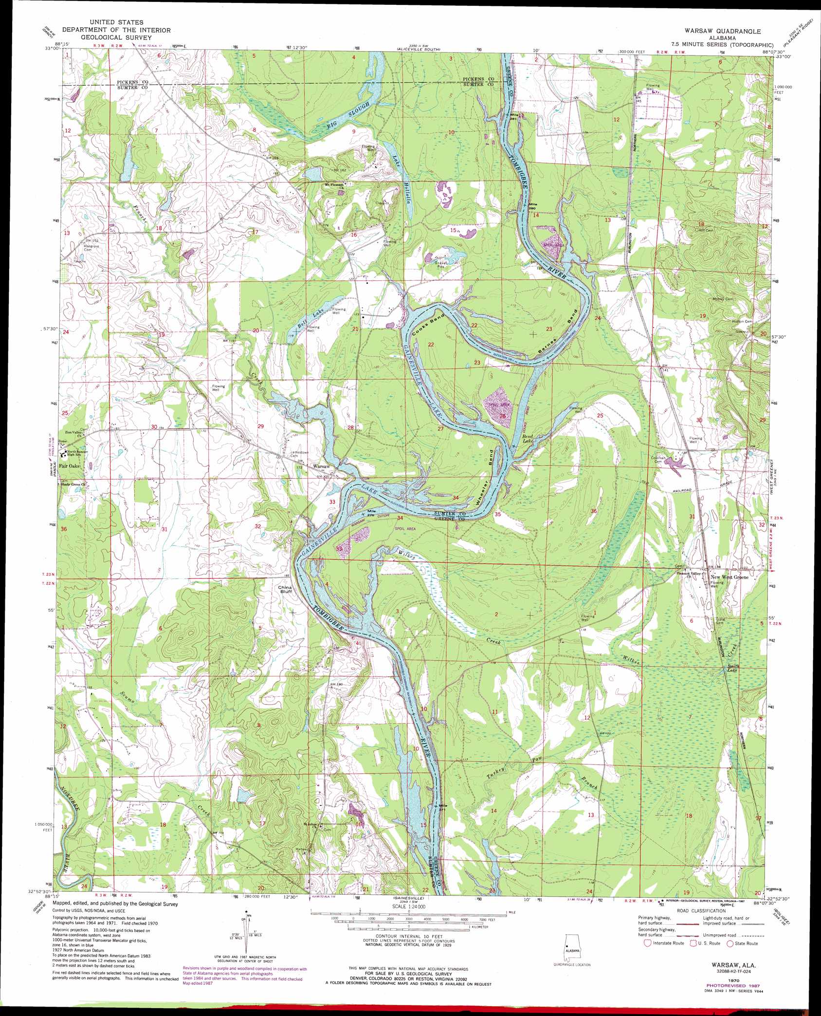
Warsaw Topo Map Alabama
To zoom in, hover over the map of Warsaw
USGS Topo Quad 32088h2 - 1:24,000 scale
| Topo Map Name: | Warsaw |
| USGS Topo Quad ID: | 32088h2 |
| Print Size: | ca. 21 1/4" wide x 27" high |
| Southeast Coordinates: | 32.875° N latitude / 88.125° W longitude |
| Map Center Coordinates: | 32.9375° N latitude / 88.1875° W longitude |
| U.S. State: | AL |
| Filename: | o32088h2.jpg |
| Download Map JPG Image: | Warsaw topo map 1:24,000 scale |
| Map Type: | Topographic |
| Topo Series: | 7.5´ |
| Map Scale: | 1:24,000 |
| Source of Map Images: | United States Geological Survey (USGS) |
| Alternate Map Versions: |
Warsaw AL 1970, updated 1973 Download PDF Buy paper map Warsaw AL 1970, updated 1987 Download PDF Buy paper map Warsaw AL 2011 Download PDF Buy paper map Warsaw AL 2014 Download PDF Buy paper map |
1:24,000 Topo Quads surrounding Warsaw
Cliftonville |
Pickensville |
Aliceville North |
Cunningham |
Kirk |
Mcleod |
Dancy |
Aliceville South |
Pleasant Ridge |
Mantua |
Paulette |
Panola |
Warsaw |
West Greene |
Union |
Scooba |
Geiger |
Gainesville |
Boligee |
Eutaw |
Porterville |
Emelle |
Epes West |
Epes East |
Forkland |
> Back to 32088e1 at 1:100,000 scale
> Back to 32088a1 at 1:250,000 scale
> Back to U.S. Topo Maps home
Warsaw topo map: Gazetteer
Warsaw: Bars
Barnes Gin Bar elevation 34m 111′Bracketts Bar elevation 33m 108′
Carpenters Bar elevation 33m 108′
China Bluff Bar elevation 33m 108′
Craigs Shoals elevation 33m 108′
Duncans Bar elevation 33m 108′
Hiblers Bar elevation 33m 108′
Hicks Bar elevation 33m 108′
Littles Bar elevation 33m 108′
Pleasant Ridge Bar elevation 33m 108′
Warsaw Bar elevation 33m 108′
Warsaw: Bends
Barnes Bend elevation 35m 114′Cooks Bend elevation 34m 111′
Wheeler Bend elevation 34m 111′
Warsaw: Channels
Cooks Bend Cut Off elevation 33m 108′Warsaw Cut Off elevation 33m 108′
Warsaw: Cliffs
China Bluff elevation 57m 187′Warsaw: Crossings
Craigs Ferry (historical) elevation 33m 108′Johnsons Ferry (historical) elevation 33m 108′
Warsaw Ferry (historical) elevation 33m 108′
Warsaw: Dams
Jim Henderson Dam elevation 42m 137′Robert Weir Dam elevation 42m 137′
Warsaw: Guts
Big Slough elevation 33m 108′Warsaw: Islands
Littles Island (historical) elevation 33m 108′Warsaw: Lakes
Bend Lake elevation 33m 108′Lake Hollolla elevation 37m 121′
Smith Lake elevation 36m 118′
Warsaw: Parks
Barnes Bend Access Area elevation 33m 108′China Bluff Access Area elevation 53m 173′
Riverside Recreation Area elevation 34m 111′
Warsaw: Populated Places
New West Greene elevation 44m 144′Warsaw elevation 37m 121′
Warsaw: Reservoirs
Bell Lake elevation 37m 121′Jim Henderson Lake elevation 42m 137′
Robert Weir Pond elevation 42m 137′
Warsaw: Streams
Fenache Creek elevation 33m 108′Wilkes Creek elevation 33m 108′
Warsaw digital topo map on disk
Buy this Warsaw topo map showing relief, roads, GPS coordinates and other geographical features, as a high-resolution digital map file on DVD:
Gulf Coast (LA, MS, AL, FL) & Southwestern Georgia
Buy digital topo maps: Gulf Coast (LA, MS, AL, FL) & Southwestern Georgia
 & Southwestern Georgia map DVD")