Decatur Topo Map Mississippi
To zoom in, hover over the map of Decatur
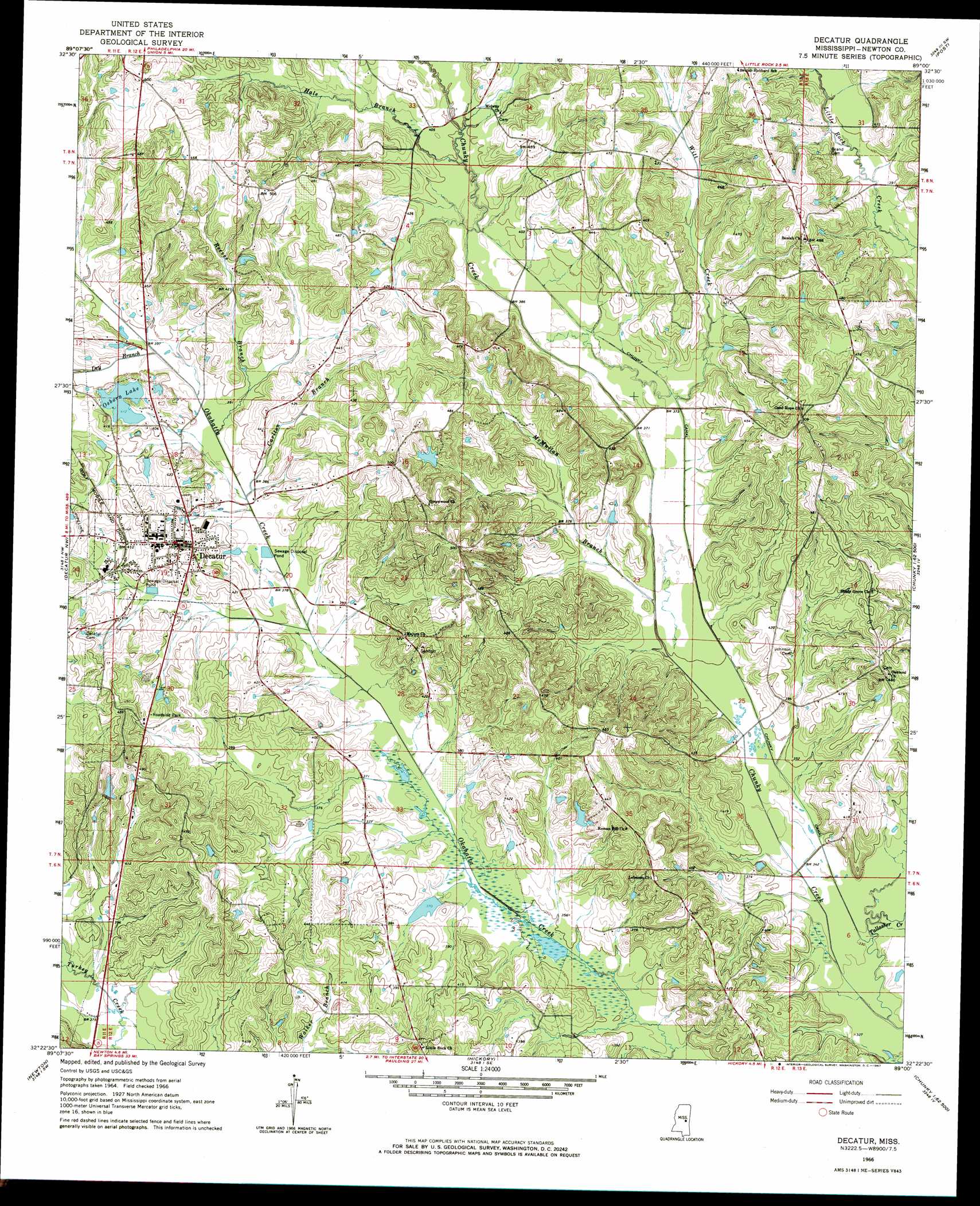
USGS Topo Quad 32089d1 - 1:24,000 scale
| Topo Map Name: | Decatur |
| USGS Topo Quad ID: | 32089d1 |
| Print Size: | ca. 21 1/4" wide x 27" high |
| Southeast Coordinates: | 32.375° N latitude / 89° W longitude |
| Map Center Coordinates: | 32.4375° N latitude / 89.0625° W longitude |
| U.S. State: | MS |
| Filename: | o32089d1.jpg |
| Download Map JPG Image: | Decatur topo map 1:24,000 scale |
| Map Type: | Topographic |
| Topo Series: | 7.5´ |
| Map Scale: | 1:24,000 |
| Source of Map Images: | United States Geological Survey (USGS) |
| Alternate Map Versions: |
Decatur MS 1966, updated 1967 Download PDF Buy paper map Decatur MS 1966, updated 1967 Download PDF Buy paper map Decatur MS 2012 Download PDF Buy paper map Decatur MS 2015 Download PDF Buy paper map |
1:24,000 Topo Quads surrounding Decatur
Madden |
Mcdonald |
Deemer |
House |
Moscow |
Sebastopol |
Union West |
Union East |
Post |
Center Hill |
Conehatta |
Decatur Nw |
Decatur |
Duffee |
Collinsville |
Lake |
Newton |
Hickory |
Chunky |
Meehan |
Clear Springs |
Montrose North |
Hero |
Rose Hill |
Stonewall |
> Back to 32089a1 at 1:100,000 scale
> Back to 32088a1 at 1:250,000 scale
> Back to U.S. Topo Maps home
Decatur topo map: Gazetteer
Decatur: Canals
Chunky Canal elevation 108m 354′Okahatta Canal elevation 112m 367′
Decatur: Dams
B L Griffin Lake Dam elevation 126m 413′C Loper Catfish Pond Dam elevation 153m 501′
C M Blount Lake Dam elevation 116m 380′
Chunky Watershed Structure 5 Dam elevation 114m 374′
Ecjc Lake Dam elevation 128m 419′
Osborn Lake Dam elevation 130m 426′
Tommy Graham Pond Dam elevation 116m 380′
Decatur: Lakes
Ozborn Lake elevation 126m 413′Decatur: Populated Places
Blounts Store elevation 134m 439′Decatur elevation 131m 429′
Goodhope elevation 153m 501′
Lebanon elevation 131m 429′
Little Rock (historical) elevation 143m 469′
Roscoe (historical) elevation 152m 498′
Decatur: Streams
Carlton Branch elevation 112m 367′Cleveland Branch elevation 128m 419′
Concobona Creek elevation 113m 370′
Decatur Branch elevation 110m 360′
Dry Branch elevation 116m 380′
Hale Branch elevation 118m 387′
Hallman Branch elevation 128m 419′
John Cook Branch elevation 103m 337′
Laird Branch elevation 128m 419′
McMullan Branch elevation 104m 341′
Reeves Branch elevation 115m 377′
Tallashua Creek elevation 100m 328′
Witt Creek elevation 110m 360′
Decatur digital topo map on disk
Buy this Decatur topo map showing relief, roads, GPS coordinates and other geographical features, as a high-resolution digital map file on DVD:
Gulf Coast (LA, MS, AL, FL) & Southwestern Georgia
Buy digital topo maps: Gulf Coast (LA, MS, AL, FL) & Southwestern Georgia
 & Southwestern Georgia map DVD")