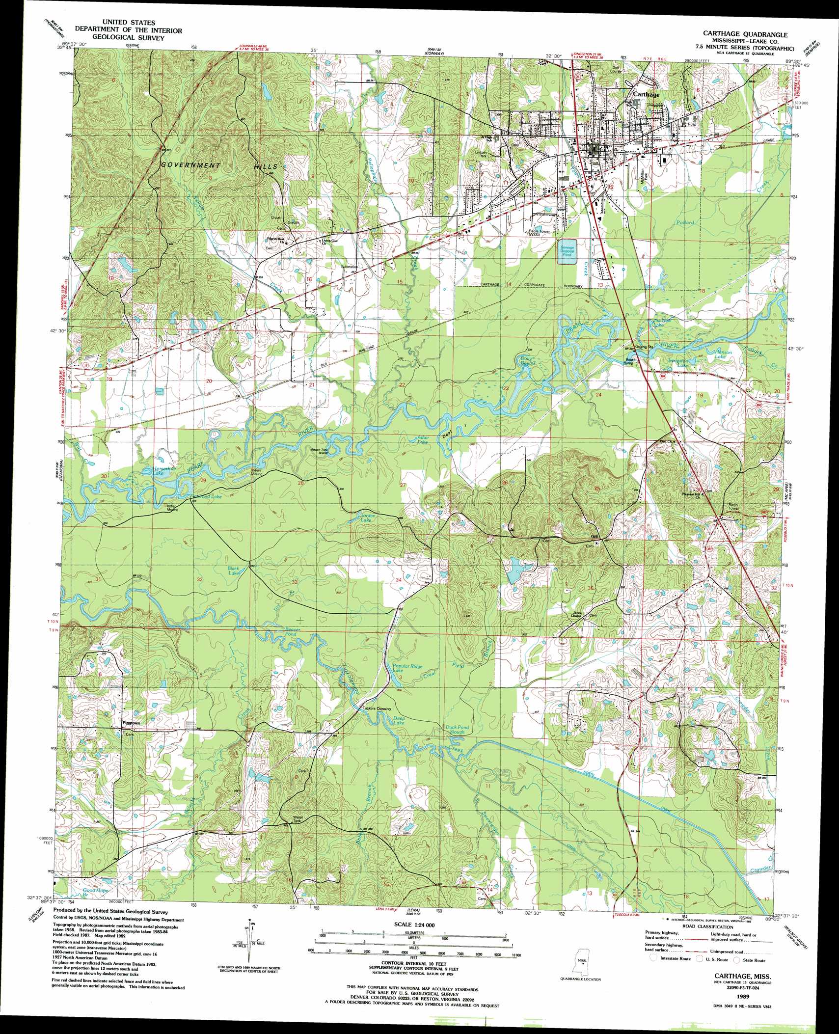
Carthage Topo Map Mississippi
To zoom in, hover over the map of Carthage
USGS Topo Quad 32089f5 - 1:24,000 scale
| Topo Map Name: | Carthage |
| USGS Topo Quad ID: | 32089f5 |
| Print Size: | ca. 21 1/4" wide x 27" high |
| Southeast Coordinates: | 32.625° N latitude / 89.5° W longitude |
| Map Center Coordinates: | 32.6875° N latitude / 89.5625° W longitude |
| U.S. State: | MS |
| Filename: | o32089f5.jpg |
| Download Map JPG Image: | Carthage topo map 1:24,000 scale |
| Map Type: | Topographic |
| Topo Series: | 7.5´ |
| Map Scale: | 1:24,000 |
| Source of Map Images: | United States Geological Survey (USGS) |
| Alternate Map Versions: |
Carthage MS 1989, updated 1989 Download PDF Buy paper map Carthage MS 2012 Download PDF Buy paper map Carthage MS 2015 Download PDF Buy paper map |
1:24,000 Topo Quads surrounding Carthage
Newport |
Joseph |
Singleton |
Zama |
Four Corners |
Camden |
Thomastown |
Conway |
Renfroe |
Edinburg |
Farmhaven |
Ofahoma |
Carthage |
Mcafee |
Madden |
Sharon Se |
Ludlow |
Lena |
Walnut Grove |
Sebastopol |
Leesburg |
Forkville |
Hillsboro |
Harperville |
Conehatta |
> Back to 32089e1 at 1:100,000 scale
> Back to 32088a1 at 1:250,000 scale
> Back to U.S. Topo Maps home
Carthage topo map: Gazetteer
Carthage: Crossings
McFaddens Ferry (historical) elevation 107m 351′Carthage: Dams
Carthage Sewage Lagoon Dam elevation 106m 347′Grover Grimes Catfish Ponds Dam elevation 117m 383′
Kermit Daughterly Lake Dam elevation 106m 347′
Carthage: Guts
Duck Pond Slough elevation 101m 331′Carthage: Islands
Deal Island elevation 100m 328′Peach Tree Island elevation 98m 321′
Carthage: Lakes
Adair Lake elevation 101m 331′Beaver Pond elevation 98m 321′
Black Lake elevation 98m 321′
Coles Ford Lake elevation 97m 318′
Deep Lake elevation 98m 321′
Flatwood Lake elevation 98m 321′
Hanson Lake elevation 100m 328′
Horseshoe Lake elevation 97m 318′
Joe Neal Lake elevation 101m 331′
Jordan Lake elevation 101m 331′
Langston Lake elevation 100m 328′
Popular Ridge Lake elevation 101m 331′
Carthage: Parks
McMillian Park elevation 108m 354′Carthage: Populated Places
Carthage elevation 107m 351′Gill elevation 149m 488′
Piggtown elevation 115m 377′
Pilgrim Rest elevation 124m 406′
Tuckers Crossing elevation 102m 334′
Carthage: Ranges
Government Hills elevation 151m 495′Carthage: Streams
Babb Branch elevation 101m 331′Balucta Creek elevation 97m 318′
Creal Field Branch elevation 98m 321′
Crowder Creek elevation 104m 341′
Dry Branch elevation 96m 314′
Pellaphalia Creek elevation 101m 331′
Pollard Creek elevation 99m 324′
Pottock Creek elevation 100m 328′
Sweetwater Creek elevation 101m 331′
Town Creek elevation 99m 324′
Witt Creek elevation 98m 321′
Yellow Creek elevation 99m 324′
Carthage: Swamps
Bully Bayou elevation 100m 328′Carthage digital topo map on disk
Buy this Carthage topo map showing relief, roads, GPS coordinates and other geographical features, as a high-resolution digital map file on DVD:
Gulf Coast (LA, MS, AL, FL) & Southwestern Georgia
Buy digital topo maps: Gulf Coast (LA, MS, AL, FL) & Southwestern Georgia
 & Southwestern Georgia map DVD")