Four Corners Topo Map Mississippi
To zoom in, hover over the map of Four Corners
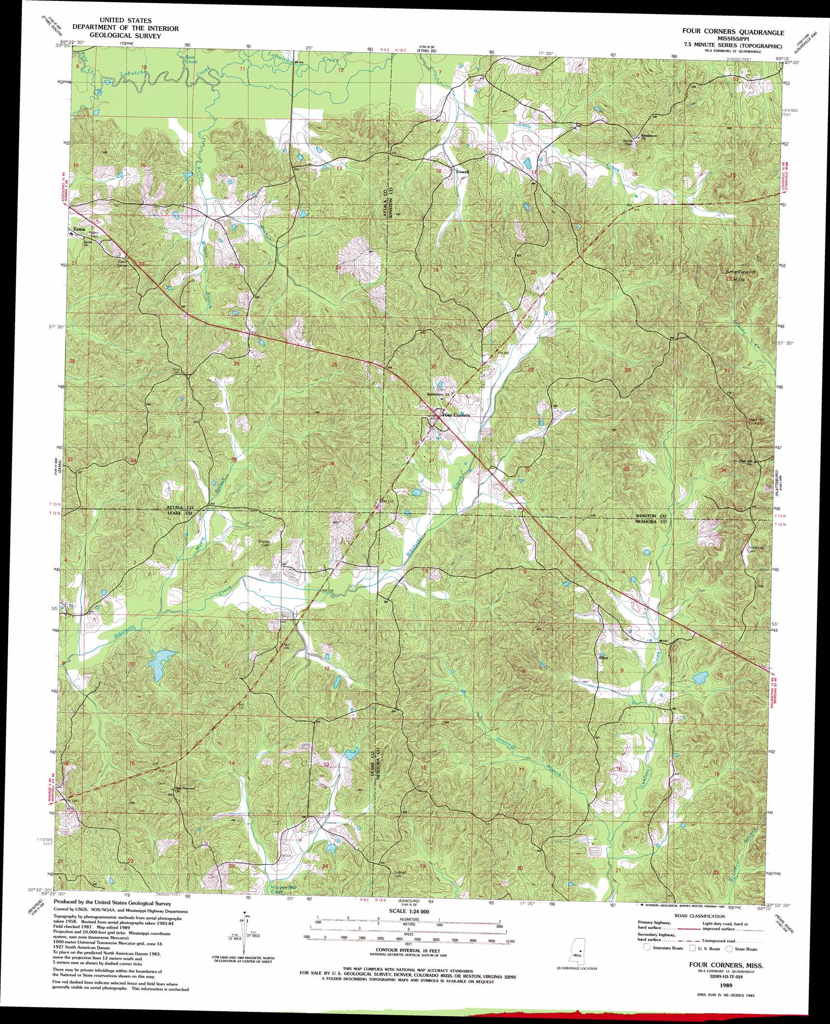
USGS Topo Quad 32089h3 - 1:24,000 scale
| Topo Map Name: | Four Corners |
| USGS Topo Quad ID: | 32089h3 |
| Print Size: | ca. 21 1/4" wide x 27" high |
| Southeast Coordinates: | 32.875° N latitude / 89.25° W longitude |
| Map Center Coordinates: | 32.9375° N latitude / 89.3125° W longitude |
| U.S. State: | MS |
| Filename: | o32089h3.jpg |
| Download Map JPG Image: | Four Corners topo map 1:24,000 scale |
| Map Type: | Topographic |
| Topo Series: | 7.5´ |
| Map Scale: | 1:24,000 |
| Source of Map Images: | United States Geological Survey (USGS) |
| Alternate Map Versions: |
Four Corners MS 1989, updated 1989 Download PDF Buy paper map Four Corners MS 2012 Download PDF Buy paper map Four Corners MS 2015 Download PDF Buy paper map |
1:24,000 Topo Quads surrounding Four Corners
Kosciusko Ne |
Ethel North |
Mccool |
Highpoint |
Louisville North |
Kosciusko |
Ethel South |
Ethel Se |
Louisville Sw |
Louisville South |
Singleton |
Zama |
Four Corners |
Plattsburg |
Noxapater |
Conway |
Renfroe |
Edinburg |
Pearl River |
Philadelphia |
Carthage |
Mcafee |
Madden |
Mcdonald |
Deemer |
> Back to 32089e1 at 1:100,000 scale
> Back to 32088a1 at 1:250,000 scale
> Back to U.S. Topo Maps home
Four Corners topo map: Gazetteer
Four Corners: Dams
Molpus Lumber Company Lake Dam elevation 155m 508′Four Corners: Populated Places
Alice elevation 156m 511′Vowell elevation 137m 449′
Four Corners: Streams
Bear Creek elevation 125m 410′Jennings Branch elevation 123m 403′
Kelley Branch elevation 125m 410′
Kyle Creek elevation 123m 403′
Myers Branch elevation 128m 419′
Wilkins Branch elevation 130m 426′
Four Corners: Summits
Smallwood Hills elevation 197m 646′Four Corners digital topo map on disk
Buy this Four Corners topo map showing relief, roads, GPS coordinates and other geographical features, as a high-resolution digital map file on DVD:
Gulf Coast (LA, MS, AL, FL) & Southwestern Georgia
Buy digital topo maps: Gulf Coast (LA, MS, AL, FL) & Southwestern Georgia
 & Southwestern Georgia map DVD")