Jackson Se Topo Map Mississippi
To zoom in, hover over the map of Jackson Se
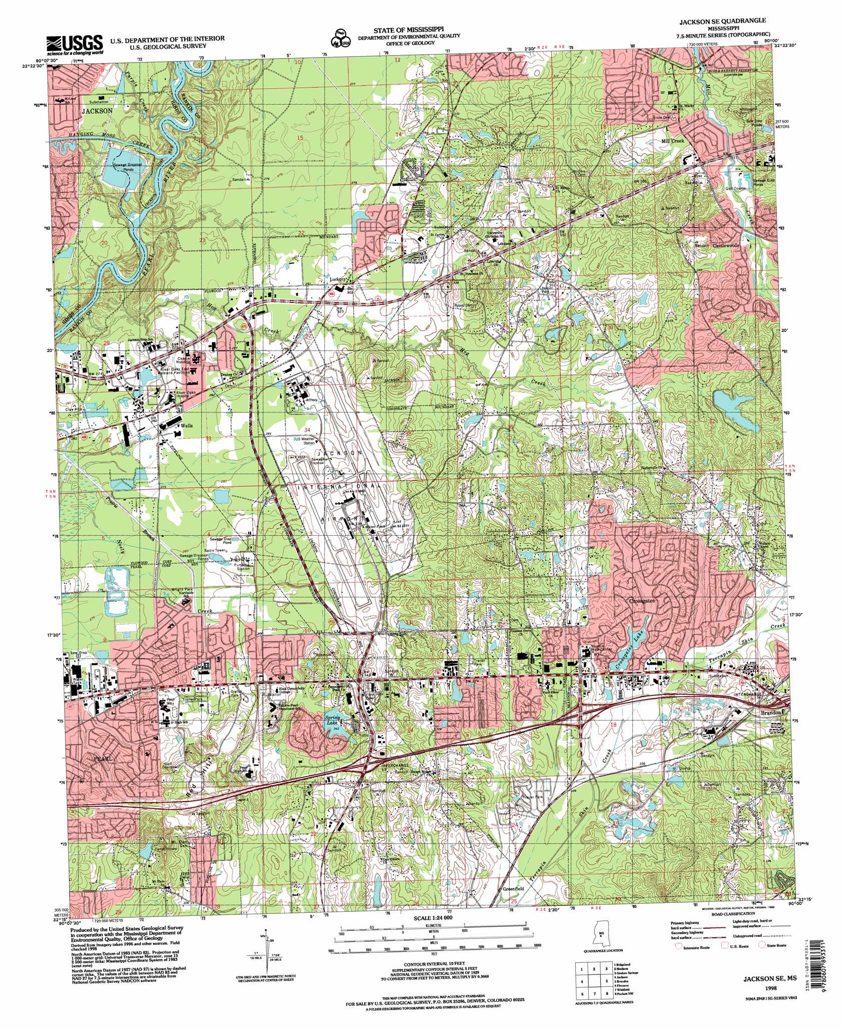
USGS Topo Quad 32090c1 - 1:24,000 scale
| Topo Map Name: | Jackson Se |
| USGS Topo Quad ID: | 32090c1 |
| Print Size: | ca. 21 1/4" wide x 27" high |
| Southeast Coordinates: | 32.25° N latitude / 90° W longitude |
| Map Center Coordinates: | 32.3125° N latitude / 90.0625° W longitude |
| U.S. State: | MS |
| Filename: | o32090c1.jpg |
| Download Map JPG Image: | Jackson Se topo map 1:24,000 scale |
| Map Type: | Topographic |
| Topo Series: | 7.5´ |
| Map Scale: | 1:24,000 |
| Source of Map Images: | United States Geological Survey (USGS) |
| Alternate Map Versions: |
Jackson SE MS 1963, updated 1964 Download PDF Buy paper map Jackson SE MS 1963, updated 1971 Download PDF Buy paper map Jackson SE MS 1963, updated 1972 Download PDF Buy paper map Jackson SE MS 1980, updated 1980 Download PDF Buy paper map Jackson SE MS 1980, updated 1986 Download PDF Buy paper map Jackson SE MS 1998, updated 1998 Download PDF Buy paper map Jackson SE MS 2012 Download PDF Buy paper map Jackson SE MS 2015 Download PDF Buy paper map |
1:24,000 Topo Quads surrounding Jackson Se
Flora |
Charlton |
Canton |
Shoccoe |
Sharon Se |
Pocahontas |
Ridgeland |
Madison |
Goshen Springs |
Leesburg |
Clinton |
Jackson |
Jackson Se |
Brandon |
Pelahatchie |
New Byram |
Florence |
Whitfield |
Puckett Nw |
Johns |
Terry |
Whites |
Star |
Braxton |
Puckett |
> Back to 32090a1 at 1:100,000 scale
> Back to 32090a1 at 1:250,000 scale
> Back to U.S. Topo Maps home
Jackson Se topo map: Gazetteer
Jackson Se: Airports
Allen C Thompson Field elevation 101m 331′Jackson International Airport elevation 99m 324′
Jackson Se: Crossings
Interchange 52 elevation 122m 400′Interchange 54 elevation 106m 347′
Interchange 56 elevation 124m 406′
Wards Ferry (historical) elevation 77m 252′
Jackson Se: Dams
Cofo Lake Dam elevation 102m 334′Crossgates Lake Dam elevation 106m 347′
Jackson Sewage Lagoon Dam elevation 85m 278′
Patrick Lake Dam elevation 106m 347′
Spring Lake Dam elevation 102m 334′
Jackson Se: Flats
Bald Prairie elevation 100m 328′Jackson Se: Parks
Brandon Park elevation 105m 344′Bright Park elevation 85m 278′
Crossgates Park elevation 104m 341′
Jackson Se: Populated Places
Belaire elevation 88m 288′Bellegrove elevation 100m 328′
Bridlewood elevation 117m 383′
Castlewoods elevation 116m 380′
Country Place elevation 116m 380′
Creekwood Place elevation 104m 341′
Crossgates elevation 110m 360′
Cunningham Heights elevation 97m 318′
Dogwood Place elevation 96m 314′
East Manor Estates elevation 86m 282′
Grove Park elevation 118m 387′
Hickory Glen elevation 86m 282′
Hunters Woods elevation 111m 364′
Kings Heights elevation 88m 288′
Luckney elevation 91m 298′
McLaurin Heights elevation 94m 308′
Mill Creek elevation 97m 318′
Mill Creek Corners elevation 98m 321′
Mill Creek Place elevation 98m 321′
Northwoods elevation 97m 318′
Patton Place elevation 90m 295′
Sherwood Forest elevation 98m 321′
Skyway Hills elevation 98m 321′
Summerwood elevation 104m 341′
Terrapin Hill elevation 108m 354′
The Commons elevation 123m 403′
Wells elevation 84m 275′
Jackson Se: Reservoirs
Crossgates Lake elevation 104m 341′Spring Lake elevation 101m 331′
Jackson Se: Streams
Hanging Moss Creek elevation 80m 262′Hog Creek elevation 78m 255′
Purple Creek elevation 80m 262′
Jackson Se: Summits
Red Hill elevation 129m 423′Jackson Se digital topo map on disk
Buy this Jackson Se topo map showing relief, roads, GPS coordinates and other geographical features, as a high-resolution digital map file on DVD: