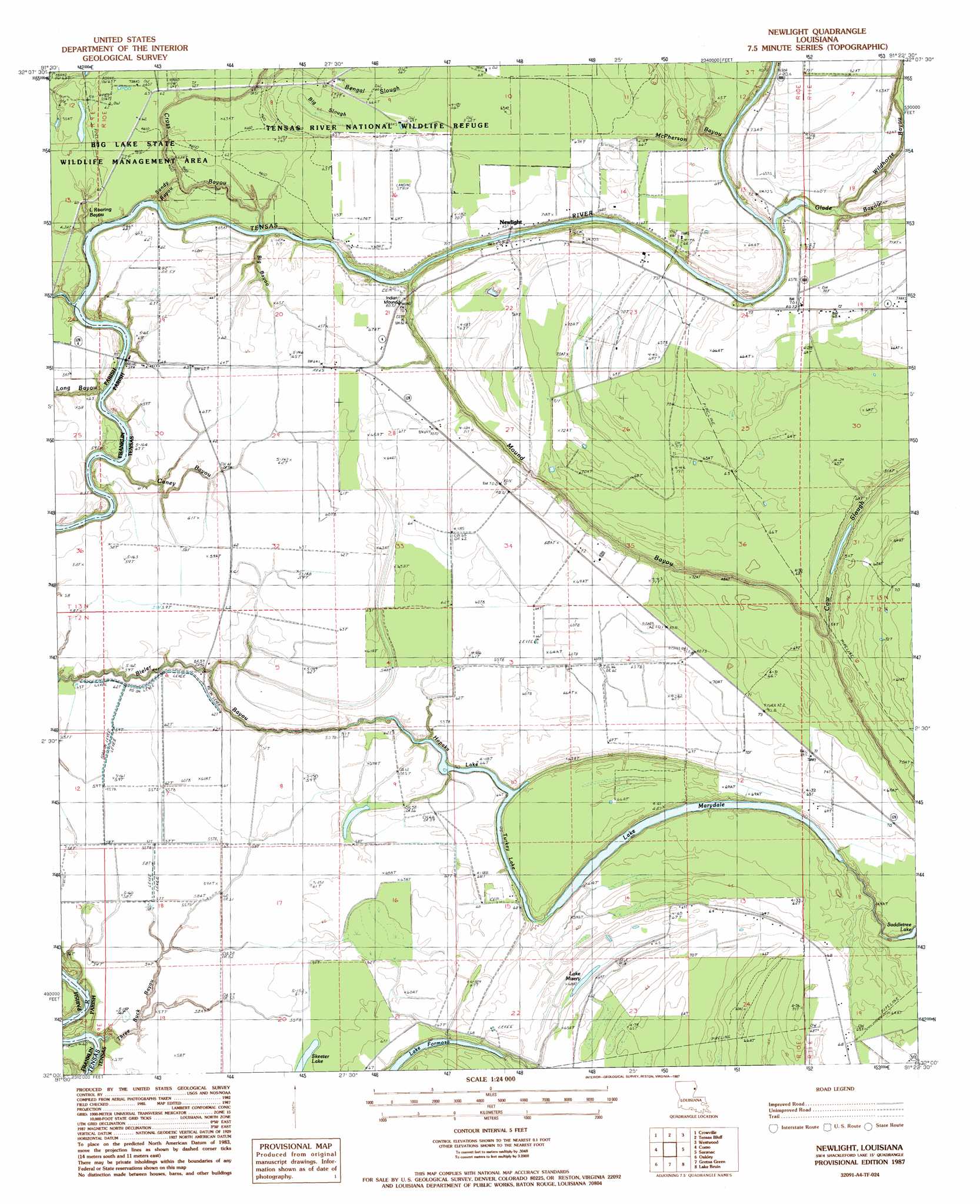
Newlight Topo Map Louisiana
To zoom in, hover over the map of Newlight
USGS Topo Quad 32091a4 - 1:24,000 scale
| Topo Map Name: | Newlight |
| USGS Topo Quad ID: | 32091a4 |
| Print Size: | ca. 21 1/4" wide x 27" high |
| Southeast Coordinates: | 32° N latitude / 91.375° W longitude |
| Map Center Coordinates: | 32.0625° N latitude / 91.4375° W longitude |
| U.S. State: | LA |
| Filename: | o32091a4.jpg |
| Download Map JPG Image: | Newlight topo map 1:24,000 scale |
| Map Type: | Topographic |
| Topo Series: | 7.5´ |
| Map Scale: | 1:24,000 |
| Source of Map Images: | United States Geological Survey (USGS) |
| Alternate Map Versions: |
NewLight LA 1987, updated 1987 Download PDF Buy paper map Newlight LA 2012 Download PDF Buy paper map Newlight LA 2015 Download PDF Buy paper map |
1:24,000 Topo Quads surrounding Newlight
Baskinton |
Lamar |
Indian Lake |
Waverly Se |
Fortune Fork |
Winnsboro |
Crowville |
Tensas Bluff |
Westwood |
Somerset |
Gilbert |
Como |
Newlight |
Saranac |
Newellton |
Wisner |
Oakley |
Gretna Green |
Lake Bruin |
Saint Joseph |
Sicily Island |
Foules |
Waterproof |
Chamblee |
Rodney |
> Back to 32091a1 at 1:100,000 scale
> Back to 32090a1 at 1:250,000 scale
> Back to U.S. Topo Maps home
Newlight topo map: Gazetteer
Newlight: Guts
Bengal Slough elevation 19m 62′Bieler Bayou elevation 12m 39′
Big Bayou elevation 20m 65′
Big Slough elevation 20m 65′
Caney Bayou elevation 19m 62′
McPherson Bayou elevation 20m 65′
Mound Bayou elevation 14m 45′
Sandy Bayou elevation 20m 65′
Three Buck Bayou elevation 17m 55′
Newlight: Lakes
Hopaka Lake elevation 14m 45′Lake Marydale elevation 14m 45′
Lake Misery elevation 17m 55′
Turkey Lake elevation 14m 45′
Newlight: Oilfields
Glade Bayou Oil Field elevation 20m 65′Lake Formosa Oil Field elevation 19m 62′
Newlight Oil elevation 20m 65′
North Lake Marydale Oil Field elevation 21m 68′
Pecan Landing Oil Field elevation 21m 68′
West Newlight Oil and Gas Field elevation 18m 59′
Newlight: Populated Places
Ferry Newlight Landing elevation 17m 55′Glade Bayou Landing elevation 11m 36′
Newlight elevation 14m 45′
Pecan Landing elevation 21m 68′
Remolina Landing elevation 20m 65′
Newlight: Streams
Big Roaring Bayou elevation 10m 32′Little Roaring Bayou elevation 10m 32′
Long Bayou elevation 10m 32′
Newlight digital topo map on disk
Buy this Newlight topo map showing relief, roads, GPS coordinates and other geographical features, as a high-resolution digital map file on DVD: