Tensas Bluff Topo Map Louisiana
To zoom in, hover over the map of Tensas Bluff
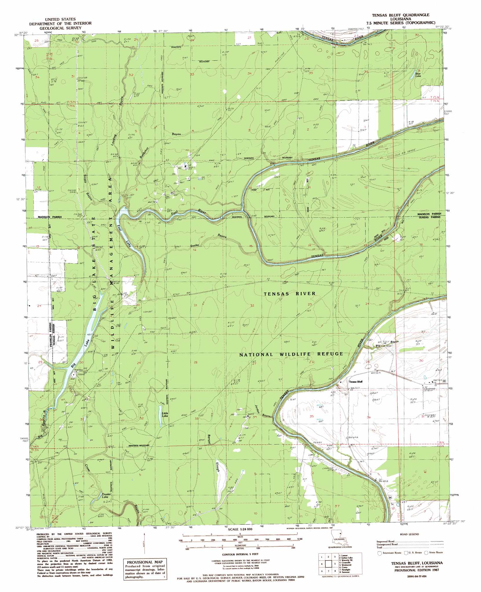
USGS Topo Quad 32091b4 - 1:24,000 scale
| Topo Map Name: | Tensas Bluff |
| USGS Topo Quad ID: | 32091b4 |
| Print Size: | ca. 21 1/4" wide x 27" high |
| Southeast Coordinates: | 32.125° N latitude / 91.375° W longitude |
| Map Center Coordinates: | 32.1875° N latitude / 91.4375° W longitude |
| U.S. State: | LA |
| Filename: | o32091b4.jpg |
| Download Map JPG Image: | Tensas Bluff topo map 1:24,000 scale |
| Map Type: | Topographic |
| Topo Series: | 7.5´ |
| Map Scale: | 1:24,000 |
| Source of Map Images: | United States Geological Survey (USGS) |
| Alternate Map Versions: |
Tensas Bluff LA 1987, updated 1987 Download PDF Buy paper map Tensas Bluff LA 1998, updated 2002 Download PDF Buy paper map Tensas Bluff LA 2012 Download PDF Buy paper map Tensas Bluff LA 2015 Download PDF Buy paper map |
1:24,000 Topo Quads surrounding Tensas Bluff
Bee Bayou |
Dunn |
Africa Lake |
Tendal |
Tallulah |
Baskinton |
Lamar |
Indian Lake |
Waverly Se |
Fortune Fork |
Winnsboro |
Crowville |
Tensas Bluff |
Westwood |
Somerset |
Gilbert |
Como |
Newlight |
Saranac |
Newellton |
Wisner |
Oakley |
Gretna Green |
Lake Bruin |
Saint Joseph |
> Back to 32091a1 at 1:100,000 scale
> Back to 32090a1 at 1:250,000 scale
> Back to U.S. Topo Maps home
Tensas Bluff topo map: Gazetteer
Tensas Bluff: Airports
Norris Airstrip elevation 21m 68′Tensas Bluff: Guts
Cross Bayou elevation 18m 59′Jordan Bayou elevation 21m 68′
Leading Bayou elevation 20m 65′
Snake Bayou elevation 20m 65′
Tensas Bluff: Lakes
Big Lake elevation 16m 52′Blue Lake elevation 21m 68′
Fool Lake elevation 20m 65′
Little Lake elevation 17m 55′
Trusler Lake elevation 17m 55′
Tensas Bluff: Oilfields
Buckshot Bayou Oil Field elevation 20m 65′Killens Ferry Gas Field elevation 19m 62′
New Quarters Oil Field elevation 21m 68′
West New Quarters Oil Field elevation 19m 62′
Westwood Oil and Gas Field elevation 21m 68′
Tensas Bluff: Parks
Big Lake State Wildlife Management Area elevation 18m 59′Tensas River National Wildlife Refuge elevation 19m 62′
Tensas Bluff: Populated Places
Hopewell Landing elevation 20m 65′New Quarters elevation 20m 65′
Tensas Bluff elevation 21m 68′
Tensas Bluff Landing elevation 14m 45′
Tensas Bluff: Streams
Big Bayou elevation 17m 55′Boggy Bayou elevation 16m 52′
Buckshot Bayou elevation 20m 65′
Fool River elevation 15m 49′
Tensas Bluff digital topo map on disk
Buy this Tensas Bluff topo map showing relief, roads, GPS coordinates and other geographical features, as a high-resolution digital map file on DVD: