Dunn Topo Map Louisiana
To zoom in, hover over the map of Dunn
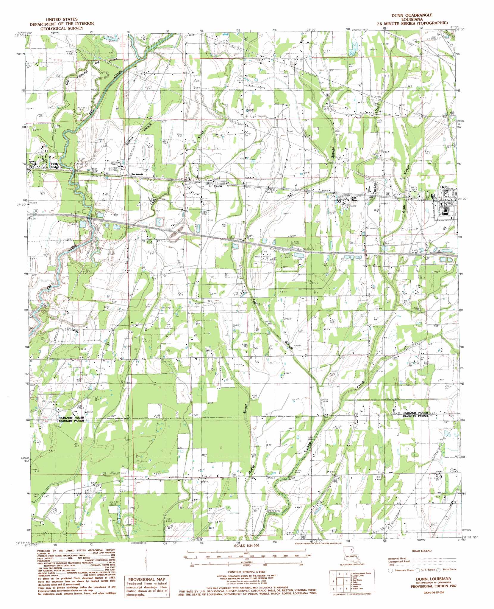
USGS Topo Quad 32091d5 - 1:24,000 scale
| Topo Map Name: | Dunn |
| USGS Topo Quad ID: | 32091d5 |
| Print Size: | ca. 21 1/4" wide x 27" high |
| Southeast Coordinates: | 32.375° N latitude / 91.5° W longitude |
| Map Center Coordinates: | 32.4375° N latitude / 91.5625° W longitude |
| U.S. State: | LA |
| Filename: | o32091d5.jpg |
| Download Map JPG Image: | Dunn topo map 1:24,000 scale |
| Map Type: | Topographic |
| Topo Series: | 7.5´ |
| Map Scale: | 1:24,000 |
| Source of Map Images: | United States Geological Survey (USGS) |
| Alternate Map Versions: |
Dunn LA 1987, updated 1987 Download PDF Buy paper map Dunn LA 2012 Download PDF Buy paper map Dunn LA 2015 Download PDF Buy paper map |
1:24,000 Topo Quads surrounding Dunn
Collinston East |
Whitney Island North |
Bear Skin |
Pioneer |
Caraway Lake |
Irwin Lake |
Whitney Island South |
Congo Creek |
Epps |
Panther Lake |
Rayville |
Bee Bayou |
Dunn |
Africa Lake |
Tendal |
Mangham |
Baskinton |
Lamar |
Indian Lake |
Waverly Se |
Liddieville |
Winnsboro |
Crowville |
Tensas Bluff |
Westwood |
> Back to 32091a1 at 1:100,000 scale
> Back to 32090a1 at 1:250,000 scale
> Back to U.S. Topo Maps home
Dunn topo map: Gazetteer
Dunn: Airports
Delhi Municipal Airport elevation 27m 88′Dunn: Crossings
Interchange 148 elevation 28m 91′Dunn: Guts
Ash Slough elevation 26m 85′Muddy Slough elevation 26m 85′
Dunn: Oilfields
Sacksonia Gas Field elevation 24m 78′Southwest Delhi Oil Field elevation 26m 85′
West Delhi Oil and Gas Field elevation 27m 88′
Dunn: Populated Places
Dunn elevation 27m 88′Sacksonia elevation 26m 85′
Dunn: Post Offices
Dunn Post Office elevation 27m 88′Dunn: Streams
Congo Creek elevation 25m 82′Glade Slough elevation 26m 85′
Little Creek elevation 23m 75′
Old Channel Big Creek elevation 23m 75′
Wildcat Slough elevation 24m 78′
Dunn digital topo map on disk
Buy this Dunn topo map showing relief, roads, GPS coordinates and other geographical features, as a high-resolution digital map file on DVD: