Cadeville Topo Map Louisiana
To zoom in, hover over the map of Cadeville
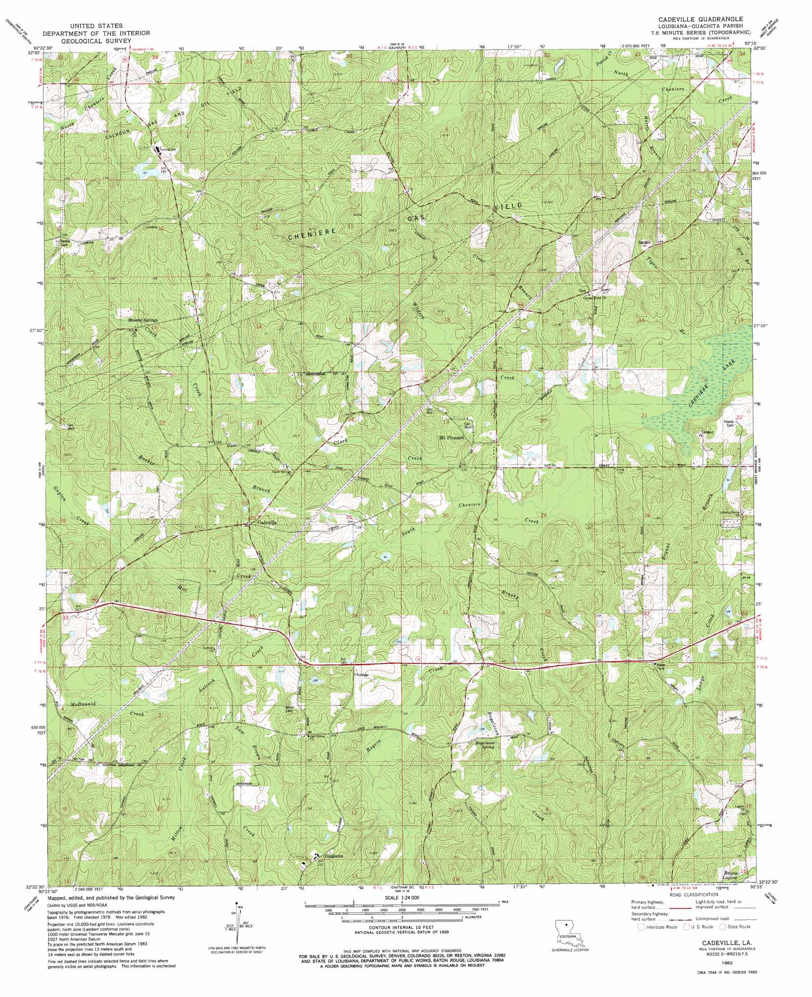
USGS Topo Quad 32092d3 - 1:24,000 scale
| Topo Map Name: | Cadeville |
| USGS Topo Quad ID: | 32092d3 |
| Print Size: | ca. 21 1/4" wide x 27" high |
| Southeast Coordinates: | 32.375° N latitude / 92.25° W longitude |
| Map Center Coordinates: | 32.4375° N latitude / 92.3125° W longitude |
| U.S. State: | LA |
| Filename: | o32092d3.jpg |
| Download Map JPG Image: | Cadeville topo map 1:24,000 scale |
| Map Type: | Topographic |
| Topo Series: | 7.5´ |
| Map Scale: | 1:24,000 |
| Source of Map Images: | United States Geological Survey (USGS) |
| Alternate Map Versions: |
Cadeville LA 1982, updated 1982 Download PDF Buy paper map Cadeville LA 2012 Download PDF Buy paper map Cadeville LA 2015 Download PDF Buy paper map |
1:24,000 Topo Quads surrounding Cadeville
Cedarton |
Downsville North |
Point |
Rocky Branch |
Sterlington |
Ruston East |
Downsville South |
Calhoun |
West Monroe North |
Monroe North |
Vernon |
Eros |
Cadeville |
West Monroe South |
Monroe South |
Curr Creek |
Chatham |
Chatham Se |
Luna |
Bosco |
Weston |
Womack |
Vixen |
Blankston |
Riverton |
> Back to 32092a1 at 1:100,000 scale
> Back to 32092a1 at 1:250,000 scale
> Back to U.S. Topo Maps home
Cadeville topo map: Gazetteer
Cadeville: Oilfields
Cheniere Gas Field elevation 52m 170′Cadeville: Populated Places
Cadeville elevation 47m 154′Lapine elevation 63m 206′
Mineral Springs elevation 46m 150′
Mount Pleasant elevation 37m 121′
Okaloosa elevation 68m 223′
Cadeville: Springs
Bogaloosa Spring elevation 39m 127′Cadeville: Streams
Antioch Creek elevation 27m 88′Bacons Branch elevation 26m 85′
Beech Branch elevation 20m 65′
Bogaloosa Creek elevation 29m 95′
Booker Branch elevation 27m 88′
Brushy Creek elevation 27m 88′
Clark Creek elevation 25m 82′
Clear Branch elevation 24m 78′
Guyton Creek elevation 37m 121′
Harris Branch elevation 24m 78′
House Branch elevation 23m 75′
Humbles Branch elevation 37m 121′
Mallard Branch elevation 23m 75′
McDonald Creek elevation 33m 108′
Mill Creek elevation 27m 88′
Milton Creek elevation 33m 108′
Patrick Creek elevation 26m 85′
Rogers Creek elevation 26m 85′
Sam Brown Creek elevation 32m 104′
South Cheniere Creek elevation 21m 68′
Tiger Branch elevation 21m 68′
Wilders Creek elevation 21m 68′
Cadeville digital topo map on disk
Buy this Cadeville topo map showing relief, roads, GPS coordinates and other geographical features, as a high-resolution digital map file on DVD: