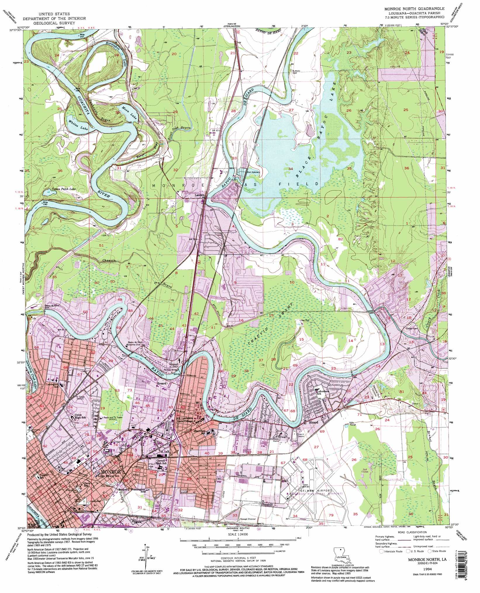
Monroe North Topo Map Louisiana
To zoom in, hover over the map of Monroe North
USGS Topo Quad 32092e1 - 1:24,000 scale
| Topo Map Name: | Monroe North |
| USGS Topo Quad ID: | 32092e1 |
| Print Size: | ca. 21 1/4" wide x 27" high |
| Southeast Coordinates: | 32.5° N latitude / 92° W longitude |
| Map Center Coordinates: | 32.5625° N latitude / 92.0625° W longitude |
| U.S. State: | LA |
| Filename: | o32092e1.jpg |
| Download Map JPG Image: | Monroe North topo map 1:24,000 scale |
| Map Type: | Topographic |
| Topo Series: | 7.5´ |
| Map Scale: | 1:24,000 |
| Source of Map Images: | United States Geological Survey (USGS) |
| Alternate Map Versions: |
Monroe North LA 1957, updated 1958 Download PDF Buy paper map Monroe North LA 1957, updated 1967 Download PDF Buy paper map Monroe North LA 1957, updated 1969 Download PDF Buy paper map Monroe North LA 1957, updated 1975 Download PDF Buy paper map Monroe North LA 1994, updated 1995 Download PDF Buy paper map Monroe North LA 1999, updated 2001 Download PDF Buy paper map Monroe North LA 2012 Download PDF Buy paper map Monroe North LA 2015 Download PDF Buy paper map |
1:24,000 Topo Quads surrounding Monroe North
De Loutre |
Haille |
Harrell Lake |
Bastrop |
Mer Rouge |
Point |
Rocky Branch |
Sterlington |
Collinston West |
Collinston East |
Calhoun |
West Monroe North |
Monroe North |
Swartz |
Irwin Lake |
Cadeville |
West Monroe South |
Monroe South |
Crew Lake |
Rayville |
Chatham Se |
Luna |
Bosco |
Gilleyville |
Mangham |
> Back to 32092e1 at 1:100,000 scale
> Back to 32092a1 at 1:250,000 scale
> Back to U.S. Topo Maps home
Monroe North topo map: Gazetteer
Monroe North: Airports
Aero Sports Ultralight Airport elevation 23m 75′Monroe Regional Airport elevation 23m 75′
Monroe North: Bridges
Phillips Bridge elevation 21m 68′Monroe North: Crossings
Interchange 117B elevation 23m 75′Monroe North: Dams
Bayou de Siard Dam elevation 21m 68′Country Club Lake Dam elevation 23m 75′
Hannas Run Dam elevation 22m 72′
Monroe North: Guts
Panhandle Bayou elevation 18m 59′River Styx elevation 21m 68′
Monroe North: Lakes
Black Bayou Lake elevation 21m 68′Cotton Patch Lake elevation 18m 59′
Fish Lake elevation 18m 59′
Horseshoe Lake elevation 18m 59′
Moon Lake elevation 18m 59′
Whites Lake elevation 18m 59′
Monroe North: Parks
Brown Stadium elevation 23m 75′Chenault Park elevation 23m 75′
Heard Tennis Stadium elevation 24m 78′
Malone Stadium elevation 22m 72′
Powell Avenue Recreation Center elevation 22m 72′
Saul Alder Recreation Area elevation 24m 78′
Monroe North: Populated Places
Belle Meade elevation 25m 82′Breard elevation 25m 82′
Chauvin Estates elevation 19m 62′
Crosley elevation 26m 85′
Cypress Point elevation 24m 78′
Edgewater elevation 25m 82′
Fish Creek elevation 24m 78′
Forest Home elevation 21m 68′
Frizzell Spur elevation 25m 82′
Lakeshore elevation 24m 78′
Lakeview Park elevation 23m 75′
Lamkin elevation 25m 82′
Leisure Village elevation 25m 82′
Monroe elevation 23m 75′
North Monroe elevation 23m 75′
Northgate elevation 24m 78′
Northpark Village elevation 22m 72′
Northside Terrace elevation 23m 75′
Oliver elevation 24m 78′
Pecan Bayou elevation 25m 82′
River Oaks elevation 22m 72′
Shenandoah elevation 25m 82′
Sicard elevation 24m 78′
Spanish City elevation 23m 75′
Suburban North elevation 29m 95′
Town and Country elevation 22m 72′
Treasure Island elevation 25m 82′
Monroe North: Post Offices
Monroe Post Office elevation 24m 78′Monroe North: Reservoirs
Country Club Lake elevation 23m 75′Monroe North: Streams
Caney Creek elevation 21m 68′East Prong Youngs Bayou elevation 22m 72′
River Styx Bayou elevation 18m 59′
West Prong Youngs Bayou elevation 22m 72′
Monroe North: Summits
Pargoud Indian Mound elevation 26m 85′Monroe North: Swamps
Chauvin Swamp elevation 19m 62′Cypress Brake elevation 20m 65′
Monroe North digital topo map on disk
Buy this Monroe North topo map showing relief, roads, GPS coordinates and other geographical features, as a high-resolution digital map file on DVD: