Grand Cane Topo Map Louisiana
To zoom in, hover over the map of Grand Cane
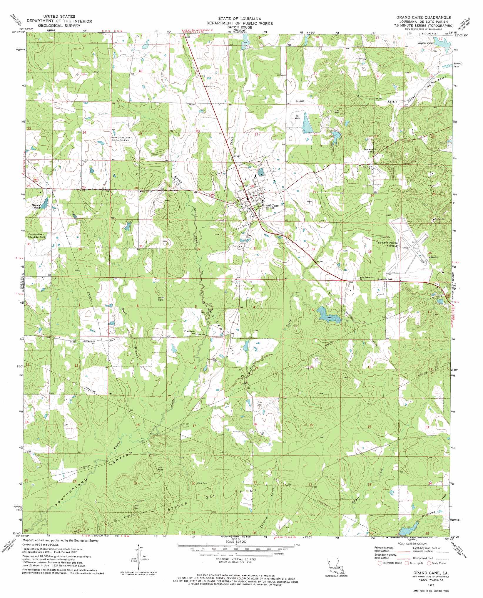
USGS Topo Quad 32093a7 - 1:24,000 scale
| Topo Map Name: | Grand Cane |
| USGS Topo Quad ID: | 32093a7 |
| Print Size: | ca. 21 1/4" wide x 27" high |
| Southeast Coordinates: | 32° N latitude / 93.75° W longitude |
| Map Center Coordinates: | 32.0625° N latitude / 93.8125° W longitude |
| U.S. State: | LA |
| Filename: | o32093a7.jpg |
| Download Map JPG Image: | Grand Cane topo map 1:24,000 scale |
| Map Type: | Topographic |
| Topo Series: | 7.5´ |
| Map Scale: | 1:24,000 |
| Source of Map Images: | United States Geological Survey (USGS) |
| Alternate Map Versions: |
Grand Cane LA 1972, updated 1974 Download PDF Buy paper map Grand Cane LA 1994, updated 1997 Download PDF Buy paper map Grand Cane LA 2012 Download PDF Buy paper map Grand Cane LA 2015 Download PDF Buy paper map |
1:24,000 Topo Quads surrounding Grand Cane
Panola |
Spring Ridge |
Stonewall |
Wallace Lake |
Elm Grove |
Old Panola |
Keatchie |
Gloster |
Holly |
Clear Lake |
Galloway |
Longstreet |
Grand Cane |
Mansfield |
Bayou Pierre Lake |
Logansport West |
Logansport East |
Hunter |
Trenton |
Pelican |
Shelbyville |
Huxley |
Union Springs |
Converse |
Pleasant Hill |
> Back to 32093a1 at 1:100,000 scale
> Back to 32092a1 at 1:250,000 scale
> Back to U.S. Topo Maps home
Grand Cane topo map: Gazetteer
Grand Cane: Airports
De Soto Parish Airport elevation 97m 318′Grand Cane: Bends
Southerland Bottom elevation 67m 219′Grand Cane: Dams
Charlie Hunter Pond Dam elevation 89m 291′Dance Pond Dam elevation 97m 318′
Eatman Estate Dam elevation 97m 318′
Lowery Pond Dam elevation 106m 347′
Rogers Pond Dam elevation 71m 232′
Stevenson Pond Dam elevation 99m 324′
Grand Cane: Oilfields
Canadian Bayou Oil and Gas Field elevation 98m 321′Grand Cane Oil Field elevation 81m 265′
North Grand Cane Oil and Gas Field elevation 105m 344′
Grand Cane: Populated Places
Grand Cane elevation 91m 298′Grand Cane: Reservoirs
Bagley Pond elevation 93m 305′Rogers Pond elevation 71m 232′
Grand Cane: Streams
Buck Branch elevation 69m 226′Cook Creek elevation 79m 259′
Wallace Creek elevation 70m 229′
Grand Cane digital topo map on disk
Buy this Grand Cane topo map showing relief, roads, GPS coordinates and other geographical features, as a high-resolution digital map file on DVD: