Elm Grove Topo Map Louisiana
To zoom in, hover over the map of Elm Grove
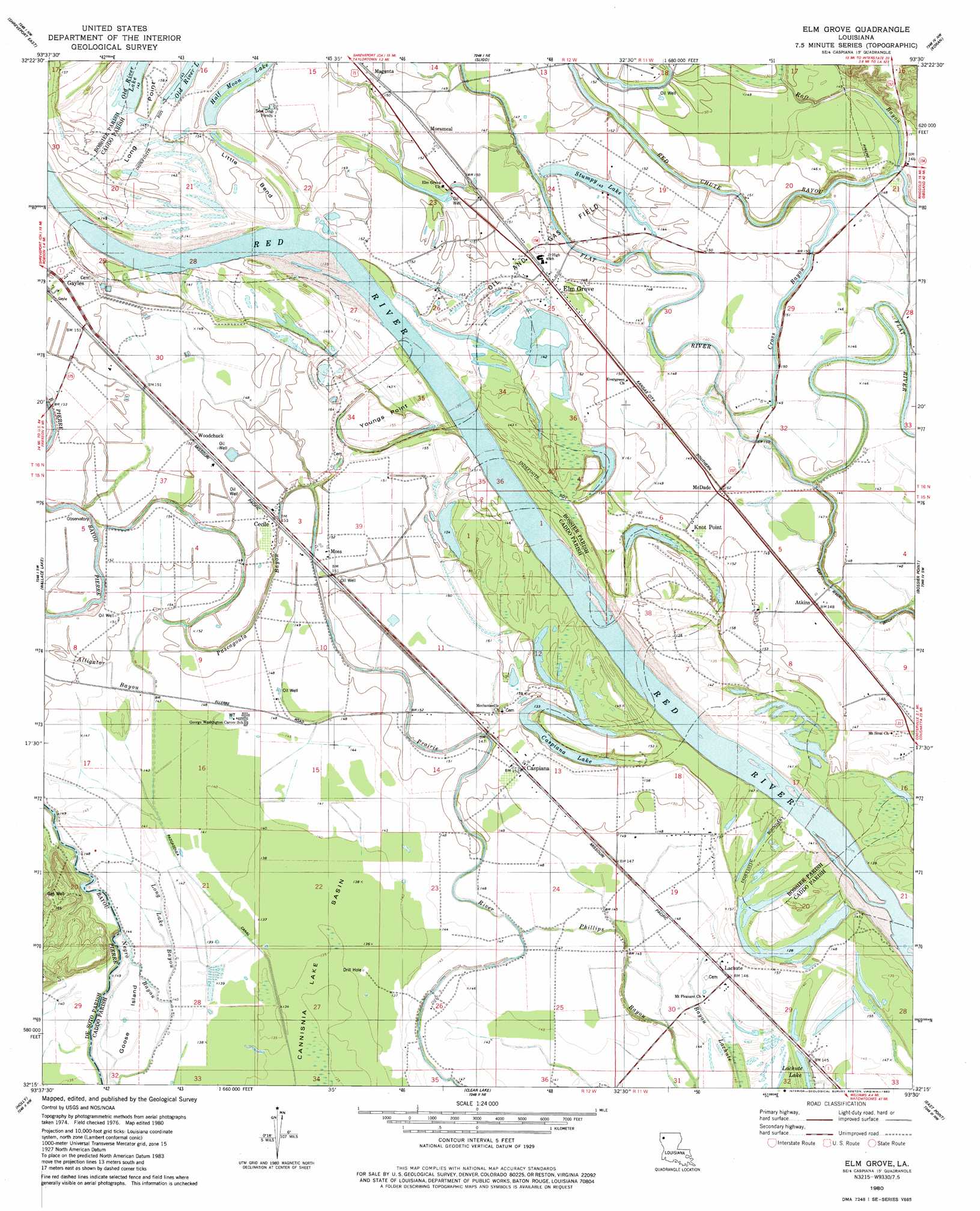
USGS Topo Quad 32093c5 - 1:24,000 scale
| Topo Map Name: | Elm Grove |
| USGS Topo Quad ID: | 32093c5 |
| Print Size: | ca. 21 1/4" wide x 27" high |
| Southeast Coordinates: | 32.25° N latitude / 93.5° W longitude |
| Map Center Coordinates: | 32.3125° N latitude / 93.5625° W longitude |
| U.S. State: | LA |
| Filename: | o32093c5.jpg |
| Download Map JPG Image: | Elm Grove topo map 1:24,000 scale |
| Map Type: | Topographic |
| Topo Series: | 7.5´ |
| Map Scale: | 1:24,000 |
| Source of Map Images: | United States Geological Survey (USGS) |
| Alternate Map Versions: |
Elm Grove LA 1980, updated 1980 Download PDF Buy paper map Elm Grove LA 1980, updated 1980 Download PDF Buy paper map Elm Grove LA 2012 Download PDF Buy paper map Elm Grove LA 2015 Download PDF Buy paper map |
1:24,000 Topo Quads surrounding Elm Grove
North Highlands |
Bossier City |
Eastwood |
Doyline |
Minden South |
Shreveport West |
Shreveport East |
Sligo |
Koran |
Heflin |
Stonewall |
Wallace Lake |
Elm Grove |
Bossier Point |
Ringgold |
Gloster |
Holly |
Clear Lake |
East Point |
Hall Summit |
Grand Cane |
Mansfield |
Bayou Pierre Lake |
Harmon |
Coushatta |
> Back to 32093a1 at 1:100,000 scale
> Back to 32092a1 at 1:250,000 scale
> Back to U.S. Topo Maps home
Elm Grove topo map: Gazetteer
Elm Grove: Bends
Little Bend elevation 47m 154′Elm Grove: Canals
Flat River Ditch elevation 40m 131′Pascagoula Canal elevation 43m 141′
Elm Grove: Capes
Youngs Point Landing elevation 47m 154′Elm Grove: Guts
Bayou Lachute elevation 41m 134′Negro Bayou elevation 43m 141′
Elm Grove: Islands
Goose Island elevation 42m 137′Elm Grove: Lakes
Caspiana Lake elevation 44m 144′Stumpy Lake elevation 43m 141′
Elm Grove: Oilfields
Atkins Gas Field elevation 46m 150′Caspiana Gas Field elevation 43m 141′
Elm Grove Oil and Gas Field elevation 46m 150′
Gayles Gas Field elevation 46m 150′
Elm Grove: Populated Places
Atkins elevation 45m 147′Caspiana elevation 46m 150′
Cecile elevation 47m 154′
Elm Grove elevation 46m 150′
Knot Point elevation 46m 150′
Lachute elevation 45m 147′
Lagas elevation 46m 150′
Magenta elevation 45m 147′
McDade elevation 46m 150′
Morameal elevation 45m 147′
Moss elevation 46m 150′
Woodchuck elevation 46m 150′
Elm Grove: Post Offices
Elm Grove Post Office elevation 46m 150′McDade Post Office (historical) elevation 46m 150′
Elm Grove: Streams
Alligators Bayou elevation 44m 144′Cross Bayou elevation 40m 131′
Pascagoula Bayou elevation 43m 141′
Raft Bayou elevation 40m 131′
Elm Grove digital topo map on disk
Buy this Elm Grove topo map showing relief, roads, GPS coordinates and other geographical features, as a high-resolution digital map file on DVD: