Wallace Lake Topo Map Louisiana
To zoom in, hover over the map of Wallace Lake
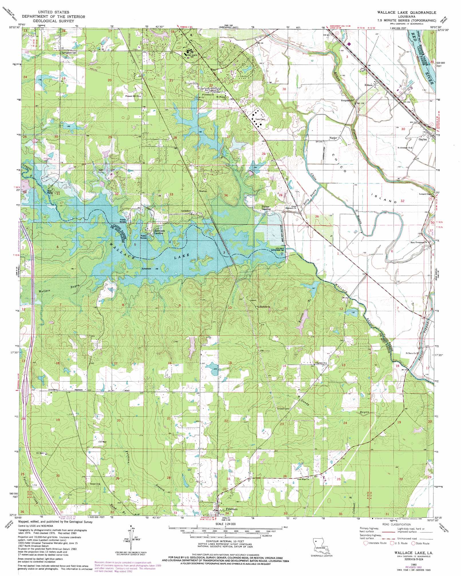
USGS Topo Quad 32093c6 - 1:24,000 scale
| Topo Map Name: | Wallace Lake |
| USGS Topo Quad ID: | 32093c6 |
| Print Size: | ca. 21 1/4" wide x 27" high |
| Southeast Coordinates: | 32.25° N latitude / 93.625° W longitude |
| Map Center Coordinates: | 32.3125° N latitude / 93.6875° W longitude |
| U.S. State: | LA |
| Filename: | o32093c6.jpg |
| Download Map JPG Image: | Wallace Lake topo map 1:24,000 scale |
| Map Type: | Topographic |
| Topo Series: | 7.5´ |
| Map Scale: | 1:24,000 |
| Source of Map Images: | United States Geological Survey (USGS) |
| Alternate Map Versions: |
Wallace Lake LA 1980, updated 1980 Download PDF Buy paper map Wallace Lake LA 1980, updated 1992 Download PDF Buy paper map Wallace Lake LA 2012 Download PDF Buy paper map Wallace Lake LA 2015 Download PDF Buy paper map |
1:24,000 Topo Quads surrounding Wallace Lake
Blanchard |
North Highlands |
Bossier City |
Eastwood |
Doyline |
Greenwood |
Shreveport West |
Shreveport East |
Sligo |
Koran |
Spring Ridge |
Stonewall |
Wallace Lake |
Elm Grove |
Bossier Point |
Keatchie |
Gloster |
Holly |
Clear Lake |
East Point |
Longstreet |
Grand Cane |
Mansfield |
Bayou Pierre Lake |
Harmon |
> Back to 32093a1 at 1:100,000 scale
> Back to 32092a1 at 1:250,000 scale
> Back to U.S. Topo Maps home
Wallace Lake topo map: Gazetteer
Wallace Lake: Airports
Heinsohns Airfield elevation 63m 206′Naylor Airport elevation 46m 150′
Wallace Lake: Dams
Wallace Lake Dam elevation 51m 167′Wallace Lake: Guts
Chico Bayou elevation 46m 150′Kelly Bayou elevation 45m 147′
Wallace Lake: Islands
Chico Island elevation 47m 154′Wallace Lake: Populated Places
Aulds (historical) elevation 63m 206′De Broeck Landing elevation 43m 141′
De Soto (historical) elevation 69m 226′
Ellerbe Woods elevation 60m 196′
Frierson elevation 58m 190′
Gayles elevation 48m 157′
Naylor elevation 48m 157′
Norton elevation 53m 173′
Palmer Landing elevation 48m 157′
Robson elevation 47m 154′
Shadow Pine Estates elevation 61m 200′
Wildoak elevation 61m 200′
Wallace Lake: Reservoirs
Wallace Lake elevation 51m 167′Wallace Lake: Streams
Gandy Bayou elevation 43m 141′Kervin Branch elevation 40m 131′
Wallace Bayou elevation 37m 121′
Wallace Bayou elevation 37m 121′
Wallace Lake digital topo map on disk
Buy this Wallace Lake topo map showing relief, roads, GPS coordinates and other geographical features, as a high-resolution digital map file on DVD: