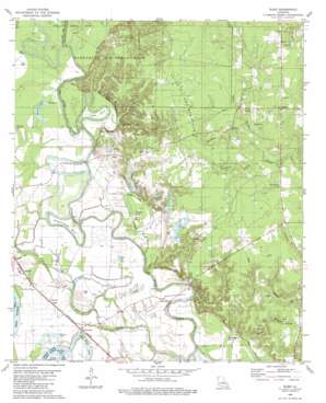
Sligo Topo Map Louisiana
To zoom in, hover over the map of Sligo
USGS Topo Quad 32093d5 - 1:24,000 scale
| Topo Map Name: | Sligo |
| USGS Topo Quad ID: | 32093d5 |
| Print Size: | ca. 21 1/4" wide x 27" high |
| Southeast Coordinates: | 32.375° N latitude / 93.5° W longitude |
| Map Center Coordinates: | 32.4375° N latitude / 93.5625° W longitude |
| U.S. State: | LA |
| Filename: | o32093d5.jpg |
| Download Map JPG Image: | Sligo topo map 1:24,000 scale |
| Map Type: | Topographic |
| Topo Series: | 7.5´ |
| Map Scale: | 1:24,000 |
| Source of Map Images: | United States Geological Survey (USGS) |
| Alternate Map Versions: |
Sligo LA 1980, updated 1980 Download PDF Buy paper map Sligo LA 2012 Download PDF Buy paper map Sligo LA 2015 Download PDF Buy paper map |
1:24,000 Topo Quads surrounding Sligo
> Back to 32093a1 at 1:100,000 scale
> Back to 32092a1 at 1:250,000 scale
> Back to U.S. Topo Maps home
Sligo topo map: Gazetteer
Sligo: Bends
Buzzard Roost Bend elevation 47m 154′Cane Bend elevation 48m 157′
Sligo: Capes
Long Point elevation 44m 144′Sligo: Guts
Marden Lake Bayou elevation 47m 154′Sligo: Lakes
Cypress Lake elevation 45m 147′Half Moon Lake elevation 45m 147′
Honey Lake elevation 45m 147′
Montgomery Lake elevation 44m 144′
Moon Lake elevation 47m 154′
Old River Lake elevation 44m 144′
Round Lake elevation 45m 147′
Walson Lake elevation 45m 147′
Sligo: Populated Places
Caplis elevation 48m 157′Mayers elevation 48m 157′
Oakland elevation 61m 200′
Palmetto elevation 43m 141′
Sligo elevation 55m 180′
Taylortown elevation 46m 150′
Sligo: Streams
Birdsnest Branch elevation 53m 173′Coleman Branch elevation 46m 150′
Fifi Bayou elevation 46m 150′
Horseshoe Creek elevation 54m 177′
Lawson Branch elevation 45m 147′
Lays Bayou elevation 41m 134′
Sligo: Swamps
Buffalo Lake elevation 45m 147′Sligo digital topo map on disk
Buy this Sligo topo map showing relief, roads, GPS coordinates and other geographical features, as a high-resolution digital map file on DVD:


