Shreveport West Topo Map Louisiana
To zoom in, hover over the map of Shreveport West
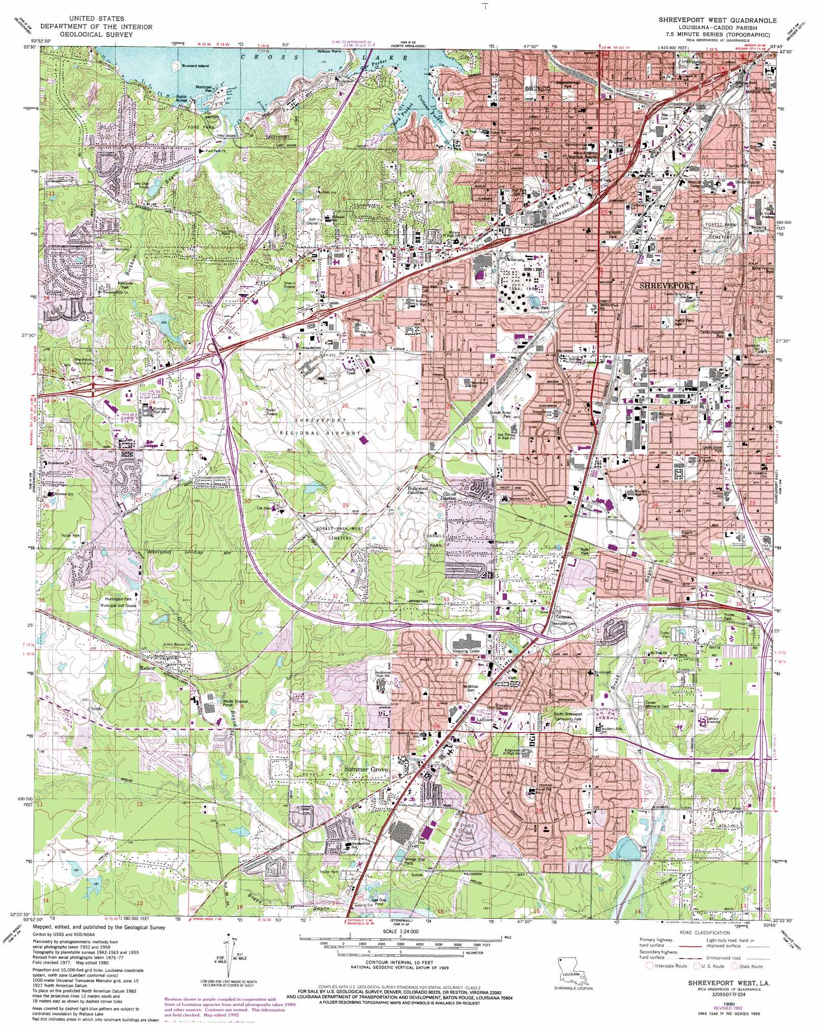
USGS Topo Quad 32093d7 - 1:24,000 scale
| Topo Map Name: | Shreveport West |
| USGS Topo Quad ID: | 32093d7 |
| Print Size: | ca. 21 1/4" wide x 27" high |
| Southeast Coordinates: | 32.375° N latitude / 93.75° W longitude |
| Map Center Coordinates: | 32.4375° N latitude / 93.8125° W longitude |
| U.S. State: | LA |
| Filename: | o32093d7.jpg |
| Download Map JPG Image: | Shreveport West topo map 1:24,000 scale |
| Map Type: | Topographic |
| Topo Series: | 7.5´ |
| Map Scale: | 1:24,000 |
| Source of Map Images: | United States Geological Survey (USGS) |
| Alternate Map Versions: |
Shreveport West LA 1955, updated 1956 Download PDF Buy paper map Shreveport West LA 1959, updated 1960 Download PDF Buy paper map Shreveport West LA 1959, updated 1969 Download PDF Buy paper map Shreveport West LA 1975, updated 1976 Download PDF Buy paper map Shreveport West LA 1980, updated 1981 Download PDF Buy paper map Shreveport West LA 1980, updated 1992 Download PDF Buy paper map Shreveport West LA 2012 Download PDF Buy paper map Shreveport West LA 2015 Download PDF Buy paper map |
1:24,000 Topo Quads surrounding Shreveport West
Potters Point |
Mooringsport |
Dixie |
Benton |
Bodcau Lake |
Latex |
Blanchard |
North Highlands |
Bossier City |
Eastwood |
Waskom |
Greenwood |
Shreveport West |
Shreveport East |
Sligo |
Panola |
Spring Ridge |
Stonewall |
Wallace Lake |
Elm Grove |
Old Panola |
Keatchie |
Gloster |
Holly |
Clear Lake |
> Back to 32093a1 at 1:100,000 scale
> Back to 32092a1 at 1:250,000 scale
> Back to U.S. Topo Maps home
Shreveport West topo map: Gazetteer
Shreveport West: Airports
LSR Medical Center Heliport elevation 61m 200′Shreveport Regional Airport elevation 69m 226′
Willis-Knighton Medical Center Temp Groundlevel Heliport elevation 78m 255′
Shreveport West: Bays
Clark Pocket elevation 52m 170′Cottons Pocket elevation 52m 170′
Gar Pocket elevation 52m 170′
Shreveport West: Crossings
Interchange 11 elevation 80m 262′Interchange 14 elevation 74m 242′
Interchange 16A elevation 71m 232′
Interchange 16B elevation 73m 239′
Interchange 17A elevation 76m 249′
Interchange 17B elevation 68m 223′
Shreveport West: Islands
Buzzard Island elevation 57m 187′Shreveport West: Parks
Airport Park elevation 66m 216′Andrew Currie Park elevation 62m 203′
Atkins Park elevation 55m 180′
Atlas Park elevation 65m 213′
Caddo Heights Park elevation 71m 232′
Cargill Park elevation 70m 229′
Cedar Grove Park elevation 66m 216′
Fairfield Historic District elevation 69m 226′
Fairground Park elevation 73m 239′
Ford Park elevation 58m 190′
Hattie Perry Park elevation 66m 216′
Hirsch Memorial Stadium elevation 78m 255′
Hollywood Heights Park elevation 69m 226′
Hyde Park elevation 61m 200′
Ingleside Park elevation 67m 219′
Jewella Park elevation 70m 229′
Mooretown Park elevation 67m 219′
Queensborough Park elevation 77m 252′
Roberts Park elevation 56m 183′
South Shreveport Community Park elevation 60m 196′
South Shreveport Park elevation 64m 209′
Spar Stadium elevation 70m 229′
Sunset Acres Park elevation 64m 209′
Thomas Field elevation 58m 190′
Westside Park elevation 62m 203′
Wildwood Park elevation 57m 187′
Shreveport West: Populated Places
Alpha Mobile Home Park elevation 50m 164′Briarcliff elevation 52m 170′
Broadview elevation 77m 252′
Brown Park Estates elevation 62m 203′
Buncombe (historical) elevation 82m 269′
Cannon elevation 81m 265′
Chasewood elevation 53m 173′
Chateau Village elevation 61m 200′
Colquitt Estates elevation 56m 183′
Cross Lake Hills South elevation 61m 200′
Cut-off Junction elevation 64m 209′
Cynthia Park elevation 72m 236′
Deep Woods elevation 56m 183′
Edgewood Village elevation 55m 180′
Elkins elevation 60m 196′
Fairfield elevation 68m 223′
Fairway Forest elevation 72m 236′
Five Oaks elevation 80m 262′
Forest Oak elevation 63m 206′
Forest Villa elevation 71m 232′
Greenbrook elevation 62m 203′
Hadley elevation 65m 213′
Hickory Place elevation 79m 259′
Holly Hill elevation 64m 209′
Hollywood elevation 59m 193′
Huntington Park elevation 70m 229′
Jewella (historical) elevation 72m 236′
King Forest elevation 61m 200′
La Rosen elevation 64m 209′
La Tierra elevation 67m 219′
Lakewood Village Mobile Home Park elevation 57m 187′
Longwood Village elevation 69m 226′
Midway elevation 73m 239′
Nichols (historical) elevation 86m 282′
Normandy Village elevation 55m 180′
Pine Forest elevation 74m 242′
Pine Forest South elevation 56m 183′
Pineland Place elevation 78m 255′
Quail Ridge elevation 73m 239′
Reisor elevation 61m 200′
Ridgewood elevation 58m 190′
Rosewood Estates elevation 68m 223′
Silver Pine Village elevation 78m 255′
South Towne Heights elevation 55m 180′
Southdowns elevation 58m 190′
Southern Hills elevation 60m 196′
Southport Country elevation 59m 193′
Steeple Chase elevation 70m 229′
Summer Grove elevation 67m 219′
The Cedars elevation 74m 242′
The Meadows elevation 63m 206′
Werner Park elevation 64m 209′
Western Hills Estates elevation 78m 255′
Western Hills Village elevation 77m 252′
Westwood Park elevation 73m 239′
Wildwood South elevation 56m 183′
Willow Ridge elevation 65m 213′
Shreveport West: Streams
Bickham Bayou elevation 52m 170′Gilmer Bayou elevation 49m 160′
Shreveport West digital topo map on disk
Buy this Shreveport West topo map showing relief, roads, GPS coordinates and other geographical features, as a high-resolution digital map file on DVD: