Minden South Topo Map Louisiana
To zoom in, hover over the map of Minden South
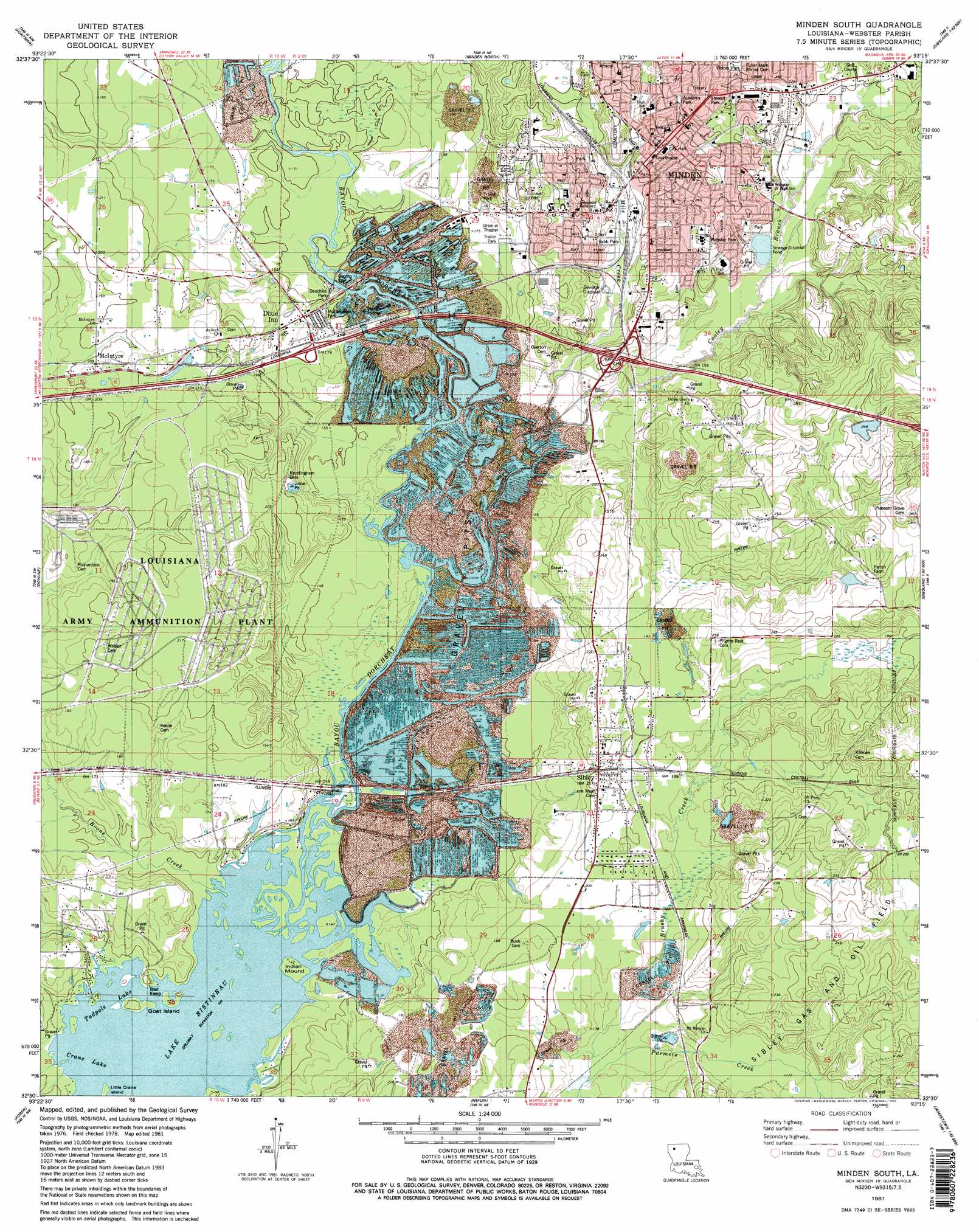
USGS Topo Quad 32093e3 - 1:24,000 scale
| Topo Map Name: | Minden South |
| USGS Topo Quad ID: | 32093e3 |
| Print Size: | ca. 21 1/4" wide x 27" high |
| Southeast Coordinates: | 32.5° N latitude / 93.25° W longitude |
| Map Center Coordinates: | 32.5625° N latitude / 93.3125° W longitude |
| U.S. State: | LA |
| Filename: | o32093e3.jpg |
| Download Map JPG Image: | Minden South topo map 1:24,000 scale |
| Map Type: | Topographic |
| Topo Series: | 7.5´ |
| Map Scale: | 1:24,000 |
| Source of Map Images: | United States Geological Survey (USGS) |
| Alternate Map Versions: |
Minden South LA 1981, updated 1982 Download PDF Buy paper map Minden South LA 1981, updated 1982 Download PDF Buy paper map Minden South LA 1998, updated 2004 Download PDF Buy paper map Minden South LA 2012 Download PDF Buy paper map Minden South LA 2015 Download PDF Buy paper map |
1:24,000 Topo Quads surrounding Minden South
Ivan |
Cotton Valley |
Leton |
Blackburn |
Homer |
Bodcau Lake |
Hortman |
Minden North |
Langston |
Athens |
Eastwood |
Doyline |
Minden South |
Ada |
Gibsland |
Sligo |
Koran |
Heflin |
Fryeburg |
Sailes |
Elm Grove |
Bossier Point |
Ringgold |
Jamestown |
Sparta |
> Back to 32093e1 at 1:100,000 scale
> Back to 32092a1 at 1:250,000 scale
> Back to U.S. Topo Maps home
Minden South topo map: Gazetteer
Minden South: Crossings
Interchange 44 elevation 48m 157′Interchange 46 elevation 59m 193′
Minden South: Dams
Smith Pond Number Four Dam elevation 75m 246′Minden South: Islands
Goat Island elevation 46m 150′Lake Crane Island elevation 43m 141′
Little Crane Island elevation 43m 141′
Minden South: Lakes
Crane Lake elevation 43m 141′Tadpole Lake elevation 43m 141′
Minden South: Parks
Academy Park elevation 78m 255′Babb Park elevation 55m 180′
City Park elevation 73m 239′
Dauchite Park elevation 46m 150′
Ewell Park Recreation Center elevation 73m 239′
McClanahan Park elevation 51m 167′
Minden Historic District elevation 75m 246′
Roosevelt Park elevation 76m 249′
Stewart Park elevation 85m 278′
Victory Park elevation 75m 246′
Webster Park elevation 72m 236′
Minden South: Populated Places
Dixie Inn elevation 53m 173′Gifford elevation 51m 167′
McIntyre elevation 63m 206′
Minden elevation 78m 255′
Overton (historical) elevation 57m 187′
Sibley elevation 62m 203′
Minden South: Post Offices
Minden Post Office elevation 75m 246′Minden South: Streams
Bayou Dorcheat elevation 43m 141′Boone Creek elevation 43m 141′
Cooley Branch elevation 47m 154′
Fellowship Branch elevation 54m 177′
Mile Creek elevation 46m 150′
Parmers Creek elevation 50m 164′
Minden South: Summits
Indian Mound elevation 43m 141′Minden South digital topo map on disk
Buy this Minden South topo map showing relief, roads, GPS coordinates and other geographical features, as a high-resolution digital map file on DVD: