Kilgore Sw Topo Map Texas
To zoom in, hover over the map of Kilgore Sw
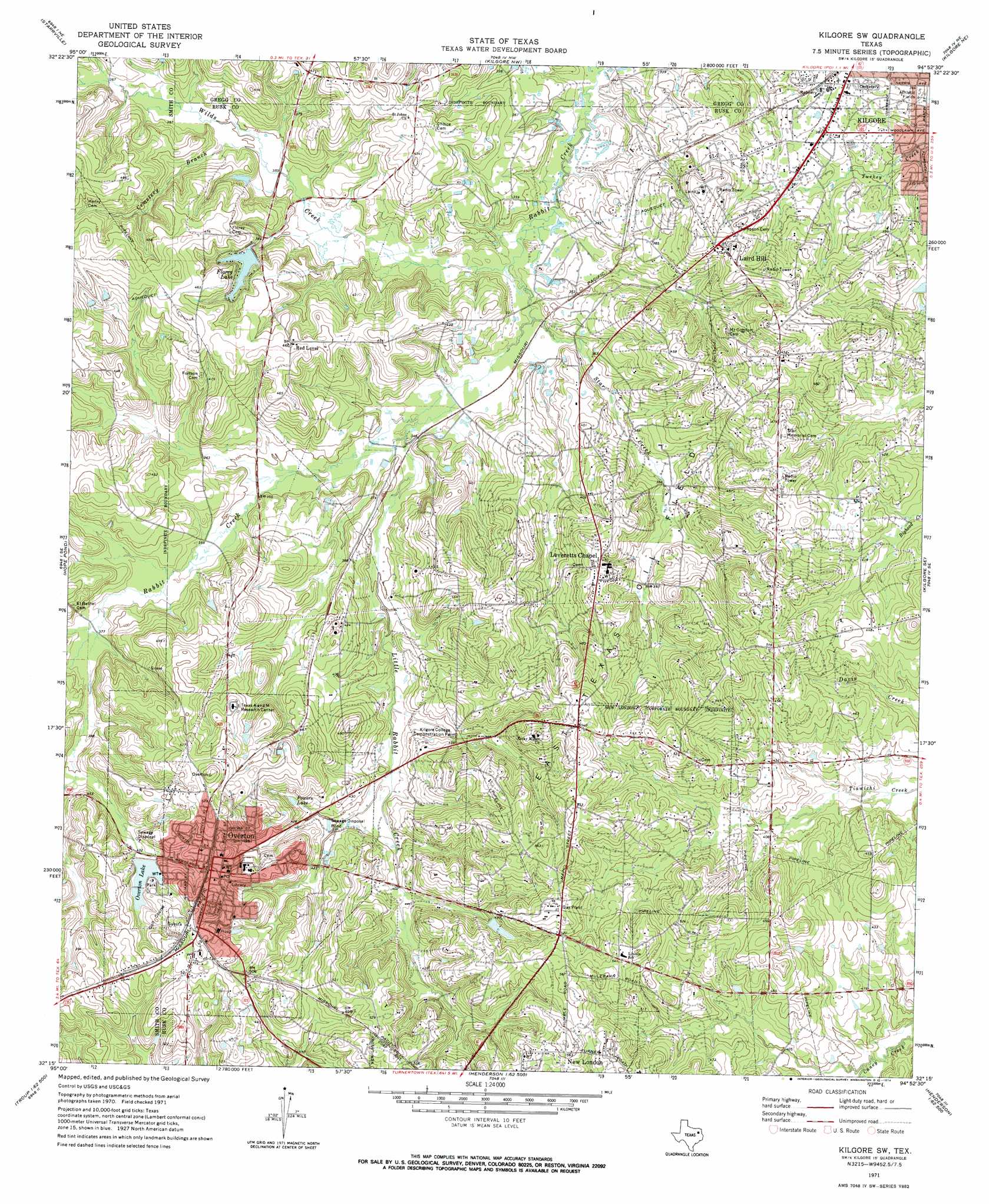
USGS Topo Quad 32094c8 - 1:24,000 scale
| Topo Map Name: | Kilgore Sw |
| USGS Topo Quad ID: | 32094c8 |
| Print Size: | ca. 21 1/4" wide x 27" high |
| Southeast Coordinates: | 32.25° N latitude / 94.875° W longitude |
| Map Center Coordinates: | 32.3125° N latitude / 94.9375° W longitude |
| U.S. State: | TX |
| Filename: | o32094c8.jpg |
| Download Map JPG Image: | Kilgore Sw topo map 1:24,000 scale |
| Map Type: | Topographic |
| Topo Series: | 7.5´ |
| Map Scale: | 1:24,000 |
| Source of Map Images: | United States Geological Survey (USGS) |
| Alternate Map Versions: |
Kilgore SW TX 1971, updated 1974 Download PDF Buy paper map Kilgore SW TX 2010 Download PDF Buy paper map Kilgore SW TX 2013 Download PDF Buy paper map Kilgore SW TX 2016 Download PDF Buy paper map |
1:24,000 Topo Quads surrounding Kilgore Sw
Hawkins |
Big Sandy |
Gladewater |
White Oak |
Longview Heights |
Winona |
Starrville |
Kilgore Nw |
Kilgore Ne |
Lakeport |
Bascom |
Hope Pond |
Kilgore Sw |
Kilgore Se |
Elderville |
Troup West |
Troup East |
Price |
Henderson |
Church Hill |
Tecula |
Griffin |
Gum Springs |
Berryhill Creek |
Minden |
> Back to 32094a1 at 1:100,000 scale
> Back to 32094a1 at 1:250,000 scale
> Back to U.S. Topo Maps home
Kilgore Sw topo map: Gazetteer
Kilgore Sw: Dams
Florey Lake Dam elevation 114m 374′North Overton Dam elevation 143m 469′
South Overton Dam elevation 139m 456′
Kilgore Sw: Lakes
Powers Lake elevation 131m 429′Kilgore Sw: Populated Places
Laird Hill elevation 141m 462′Leverett's Chapel elevation 146m 479′
Overton elevation 153m 501′
Red Level elevation 140m 459′
Sexton City elevation 165m 541′
Kilgore Sw: Reservoirs
Florey Lake elevation 123m 403′North Overton Lake elevation 143m 469′
Overton Lake elevation 139m 456′
South Overton Lake elevation 139m 456′
Kilgore Sw: Streams
Cemetery Branch elevation 104m 341′Little Rabbit Creek elevation 101m 331′
Star Creek elevation 97m 318′
Wilds Creek elevation 97m 318′
Kilgore Sw digital topo map on disk
Buy this Kilgore Sw topo map showing relief, roads, GPS coordinates and other geographical features, as a high-resolution digital map file on DVD: