Kilgore Nw Topo Map Texas
To zoom in, hover over the map of Kilgore Nw
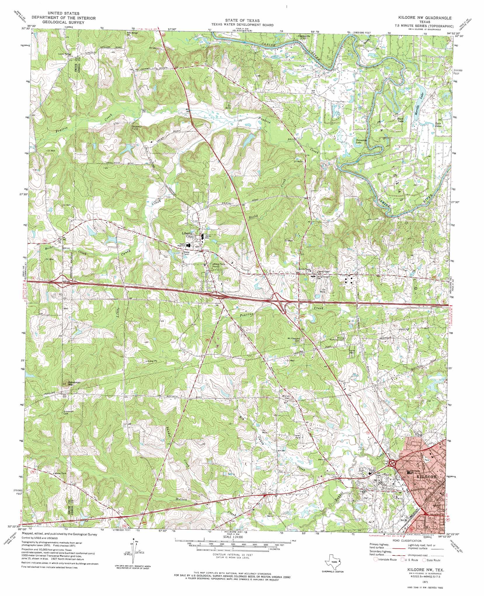
USGS Topo Quad 32094d8 - 1:24,000 scale
| Topo Map Name: | Kilgore Nw |
| USGS Topo Quad ID: | 32094d8 |
| Print Size: | ca. 21 1/4" wide x 27" high |
| Southeast Coordinates: | 32.375° N latitude / 94.875° W longitude |
| Map Center Coordinates: | 32.4375° N latitude / 94.9375° W longitude |
| U.S. State: | TX |
| Filename: | o32094d8.jpg |
| Download Map JPG Image: | Kilgore Nw topo map 1:24,000 scale |
| Map Type: | Topographic |
| Topo Series: | 7.5´ |
| Map Scale: | 1:24,000 |
| Source of Map Images: | United States Geological Survey (USGS) |
| Alternate Map Versions: |
Kilgore NW TX 1971, updated 1974 Download PDF Buy paper map Kilgore NW TX 2010 Download PDF Buy paper map Kilgore NW TX 2013 Download PDF Buy paper map Kilgore NW TX 2016 Download PDF Buy paper map |
1:24,000 Topo Quads surrounding Kilgore Nw
Shady Grove |
Pritchett |
Gilmer |
Glenwood |
Ashland |
Hawkins |
Big Sandy |
Gladewater |
White Oak |
Longview Heights |
Winona |
Starrville |
Kilgore Nw |
Kilgore Ne |
Lakeport |
Bascom |
Hope Pond |
Kilgore Sw |
Kilgore Se |
Elderville |
Troup West |
Troup East |
Price |
Henderson |
Church Hill |
> Back to 32094a1 at 1:100,000 scale
> Back to 32094a1 at 1:250,000 scale
> Back to U.S. Topo Maps home
Kilgore Nw topo map: Gazetteer
Kilgore Nw: Lakes
Black Lake elevation 82m 269′Horseshoe Lake elevation 81m 265′
Merrills Lake elevation 82m 269′
Twin Lakes elevation 82m 269′
Kilgore Nw: Populated Places
Kilgore elevation 109m 357′Liberty City elevation 119m 390′
Kilgore Nw: Streams
Belle Creek elevation 100m 328′Big Caney Creek elevation 91m 298′
Gourdneck Branch elevation 88m 288′
Helton Creek elevation 93m 305′
Little Caney Creek elevation 83m 272′
Moody Creek elevation 75m 246′
Prairie Creek elevation 75m 246′
Rocky Creek elevation 79m 259′
Sandot Creek elevation 98m 321′
Kilgore Nw: Summits
Goodman Mountain elevation 192m 629′Kilgore Nw digital topo map on disk
Buy this Kilgore Nw topo map showing relief, roads, GPS coordinates and other geographical features, as a high-resolution digital map file on DVD: