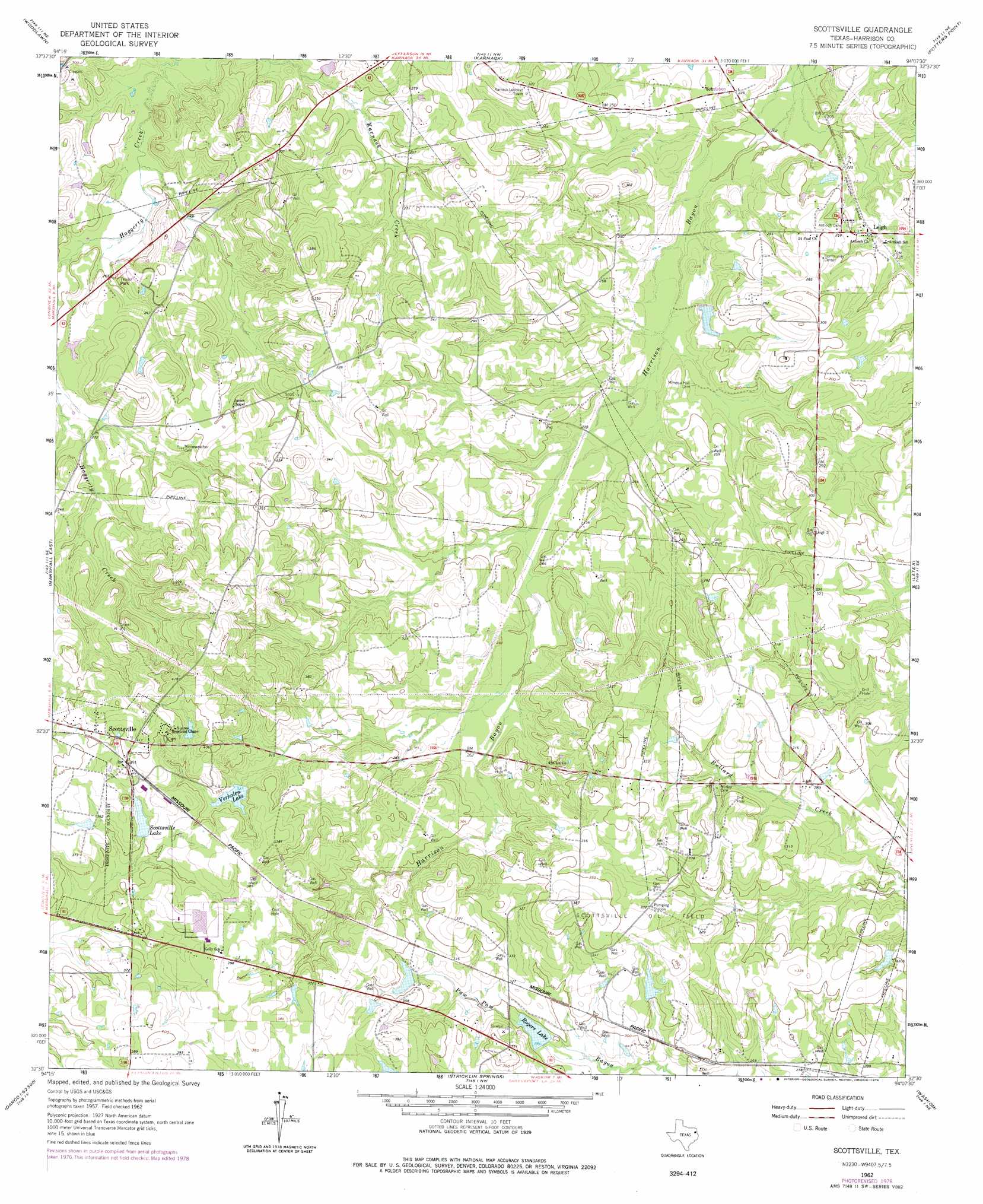
Scottsville Topo Map Texas
To zoom in, hover over the map of Scottsville
USGS Topo Quad 32094e2 - 1:24,000 scale
| Topo Map Name: | Scottsville |
| USGS Topo Quad ID: | 32094e2 |
| Print Size: | ca. 21 1/4" wide x 27" high |
| Southeast Coordinates: | 32.5° N latitude / 94.125° W longitude |
| Map Center Coordinates: | 32.5625° N latitude / 94.1875° W longitude |
| U.S. State: | TX |
| Filename: | o32094e2.jpg |
| Download Map JPG Image: | Scottsville topo map 1:24,000 scale |
| Map Type: | Topographic |
| Topo Series: | 7.5´ |
| Map Scale: | 1:24,000 |
| Source of Map Images: | United States Geological Survey (USGS) |
| Alternate Map Versions: |
Scottsville TX 1962, updated 1964 Download PDF Buy paper map Scottsville TX 1962, updated 1978 Download PDF Buy paper map Scottsville TX 2010 Download PDF Buy paper map Scottsville TX 2013 Download PDF Buy paper map Scottsville TX 2016 Download PDF Buy paper map |
1:24,000 Topo Quads surrounding Scottsville
Kellyville |
Jefferson |
Smithland |
Trees |
Vivian South |
Marshall Nw |
Woodlawn |
Karnack |
Potters Point |
Mooringsport |
Marshall West |
Marshall East |
Scottsville |
Latex |
Blanchard |
Darco |
Colliers Creek |
Stricklin Springs |
Waskom |
Greenwood |
Harris Chapel |
Grand Bluff |
De Berry |
Panola |
Spring Ridge |
> Back to 32094e1 at 1:100,000 scale
> Back to 32094a1 at 1:250,000 scale
> Back to U.S. Topo Maps home
Scottsville topo map: Gazetteer
Scottsville: Dams
Blocker Lake Dam elevation 72m 236′Rogers Lake Dam elevation 88m 288′
Scottsville Lake Dam elevation 107m 351′
Verhalen Lake Dam elevation 103m 337′
Scottsville: Oilfields
Scottsville Oil Field elevation 104m 341′Scottsville: Parks
Caddo Lake State Park and Wildlife Management Area elevation 81m 265′Scottsville: Populated Places
Leigh elevation 70m 229′Scottsville elevation 125m 410′
Scottsville: Reservoirs
Blocker Lake elevation 72m 236′Rogers Lake elevation 90m 295′
Scottsville Lake elevation 106m 347′
Verhalen Lake elevation 100m 328′
Scottsville: Streams
Butler Creek elevation 82m 269′Scottsville digital topo map on disk
Buy this Scottsville topo map showing relief, roads, GPS coordinates and other geographical features, as a high-resolution digital map file on DVD: