Lassater Topo Map Texas
To zoom in, hover over the map of Lassater
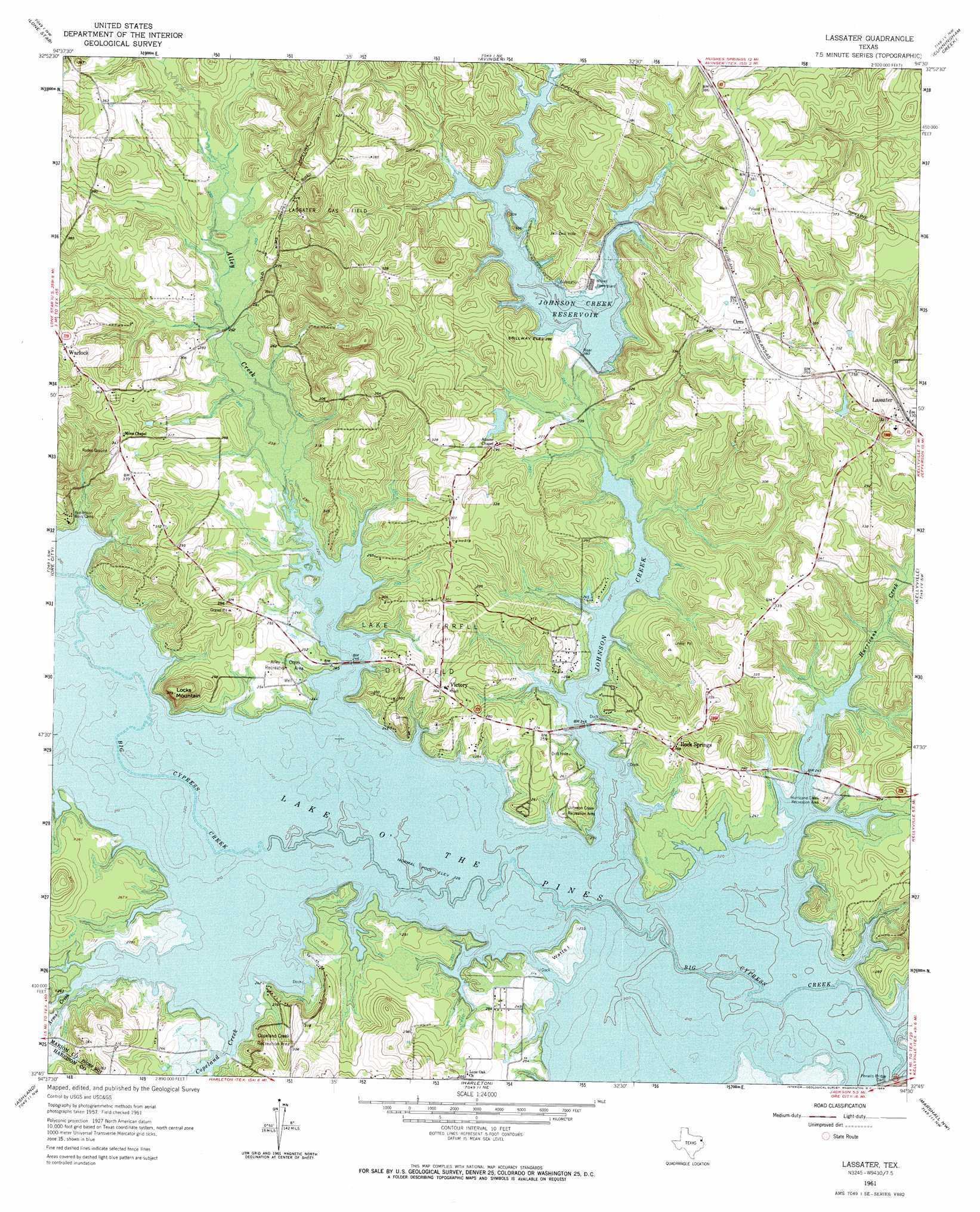
USGS Topo Quad 32094g5 - 1:24,000 scale
| Topo Map Name: | Lassater |
| USGS Topo Quad ID: | 32094g5 |
| Print Size: | ca. 21 1/4" wide x 27" high |
| Southeast Coordinates: | 32.75° N latitude / 94.5° W longitude |
| Map Center Coordinates: | 32.8125° N latitude / 94.5625° W longitude |
| U.S. State: | TX |
| Filename: | o32094g5.jpg |
| Download Map JPG Image: | Lassater topo map 1:24,000 scale |
| Map Type: | Topographic |
| Topo Series: | 7.5´ |
| Map Scale: | 1:24,000 |
| Source of Map Images: | United States Geological Survey (USGS) |
| Alternate Map Versions: |
Lassater TX 1961, updated 1964 Download PDF Buy paper map Lassater TX 2010 Download PDF Buy paper map Lassater TX 2013 Download PDF Buy paper map Lassater TX 2016 Download PDF Buy paper map |
1:24,000 Topo Quads surrounding Lassater
Cason |
Daingerfield |
Sardis |
Carterville |
Linden |
Lafayette |
Lone Star |
Avinger |
Cunningham Creek |
Lanier |
Coffeeville |
Ore City |
Lassater |
Kellyville |
Jefferson |
Glenwood |
Ashland |
Harleton |
Marshall Nw |
Woodlawn |
White Oak |
Longview Heights |
Hallsville |
Marshall West |
Marshall East |
> Back to 32094e1 at 1:100,000 scale
> Back to 32094a1 at 1:250,000 scale
> Back to U.S. Topo Maps home
Lassater topo map: Gazetteer
Lassater: Airports
McKenzie Field elevation 71m 232′Lassater: Areas
Lake Ferrell Oil Field elevation 83m 272′Lassater: Dams
Felix A Smith Lake Dam elevation 82m 269′Johnson Creek Dam elevation 85m 278′
Lassater: Islands
Watts Island elevation 75m 246′Lassater: Oilfields
Lassater Gas Field elevation 94m 308′Lassater: Parks
Alley Creek Park elevation 80m 262′Alley Creek Recreation Area elevation 85m 278′
Copeland Creek Recreation Area elevation 92m 301′
Hurricane Creek Recreation Area elevation 85m 278′
Johnson Creek Recreation Area elevation 81m 265′
Lassater: Populated Places
Lassater elevation 101m 331′Orrs elevation 119m 390′
Rock Springs elevation 88m 288′
Victory elevation 92m 301′
Warlock elevation 112m 367′
Lassater: Reservoirs
Felix A Smith Lake elevation 82m 269′Johnson Creek Reservoir elevation 87m 285′
Lassater: Springs
Rock Springs elevation 79m 259′Lassater: Streams
Alley Creek elevation 69m 226′Arms Creek elevation 69m 226′
Big Cypress Creek elevation 70m 229′
Copeland Creek elevation 69m 226′
Hurricane Creek elevation 69m 226′
Johnson Creek elevation 69m 226′
Lassater: Summits
Locks Mountain elevation 111m 364′Lassater digital topo map on disk
Buy this Lassater topo map showing relief, roads, GPS coordinates and other geographical features, as a high-resolution digital map file on DVD: