Ore City Topo Map Texas
To zoom in, hover over the map of Ore City
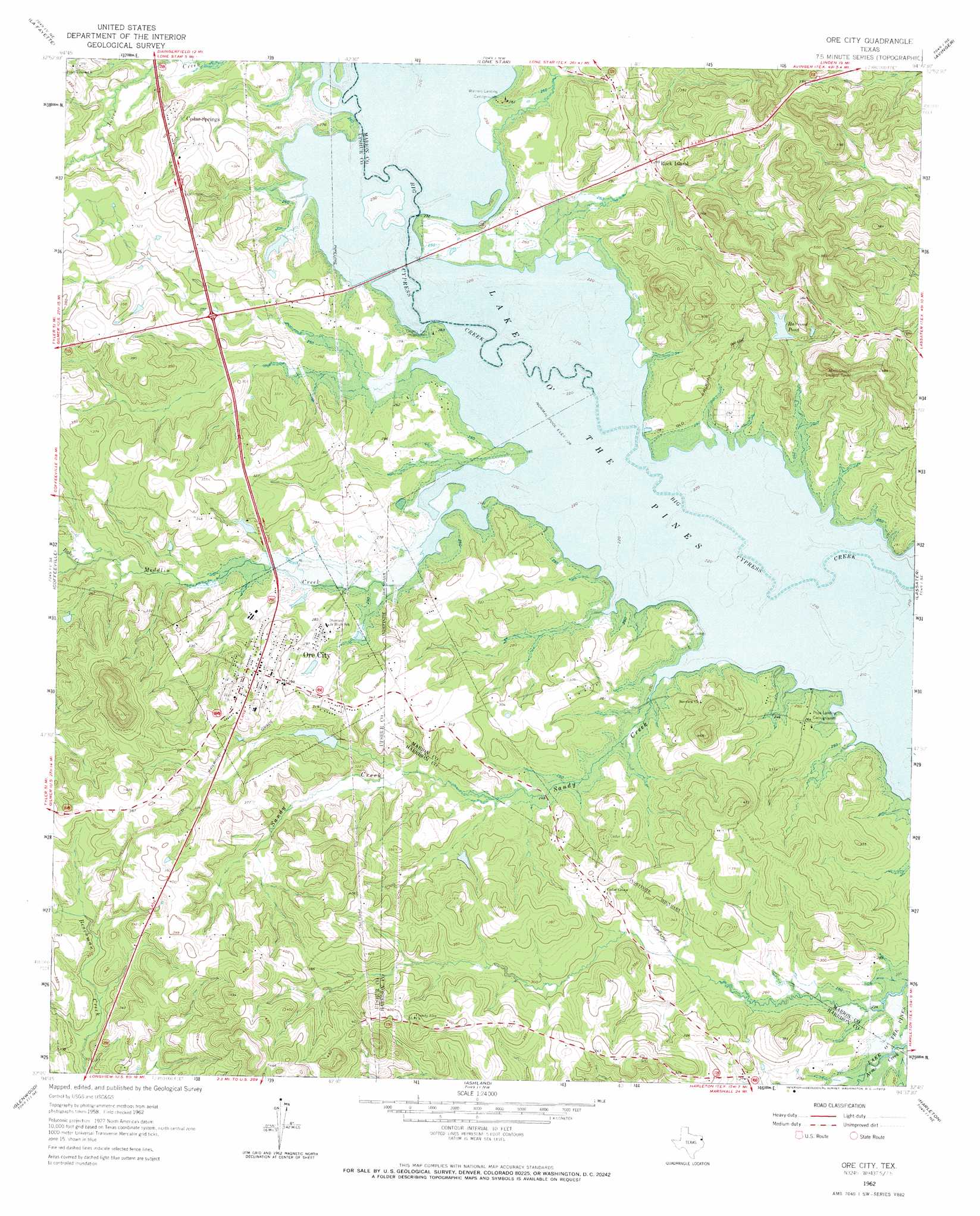
USGS Topo Quad 32094g6 - 1:24,000 scale
| Topo Map Name: | Ore City |
| USGS Topo Quad ID: | 32094g6 |
| Print Size: | ca. 21 1/4" wide x 27" high |
| Southeast Coordinates: | 32.75° N latitude / 94.625° W longitude |
| Map Center Coordinates: | 32.8125° N latitude / 94.6875° W longitude |
| U.S. State: | TX |
| Filename: | o32094g6.jpg |
| Download Map JPG Image: | Ore City topo map 1:24,000 scale |
| Map Type: | Topographic |
| Topo Series: | 7.5´ |
| Map Scale: | 1:24,000 |
| Source of Map Images: | United States Geological Survey (USGS) |
| Alternate Map Versions: |
Ore City TX 1962, updated 1964 Download PDF Buy paper map Ore City TX 1962, updated 1973 Download PDF Buy paper map Ore City TX 1962, updated 1973 Download PDF Buy paper map Ore City TX 2010 Download PDF Buy paper map Ore City TX 2013 Download PDF Buy paper map Ore City TX 2016 Download PDF Buy paper map |
1:24,000 Topo Quads surrounding Ore City
Harvard |
Cason |
Daingerfield |
Sardis |
Carterville |
Pittsburg |
Lafayette |
Lone Star |
Avinger |
Cunningham Creek |
Bettie |
Coffeeville |
Ore City |
Lassater |
Kellyville |
Gilmer |
Glenwood |
Ashland |
Harleton |
Marshall Nw |
Gladewater |
White Oak |
Longview Heights |
Hallsville |
Marshall West |
> Back to 32094e1 at 1:100,000 scale
> Back to 32094a1 at 1:250,000 scale
> Back to U.S. Topo Maps home
Ore City topo map: Gazetteer
Ore City: Airports
Hall Airport elevation 106m 347′Ore City: Dams
Ferguson Lake Dam elevation 90m 295′Lone Star Steel Lake Dam elevation 91m 298′
Satterwhite Ranch Lake Dam elevation 94m 308′
Ore City: Parks
Oak Valley Park elevation 85m 278′Ore City: Populated Places
Cedar Springs elevation 96m 314′Mims Chapel elevation 97m 318′
Ore City elevation 100m 328′
Rock Island elevation 91m 298′
Ore City: Reservoirs
Ferguson Lake elevation 90m 295′Lone Star Steel Lake elevation 91m 298′
Railroad Pond elevation 92m 301′
Satterwhite Ranch Lake elevation 94m 308′
Ore City: Streams
Baker Creek elevation 79m 259′Meddlin Creek elevation 71m 232′
Sandy Creek elevation 69m 226′
Ore City digital topo map on disk
Buy this Ore City topo map showing relief, roads, GPS coordinates and other geographical features, as a high-resolution digital map file on DVD: