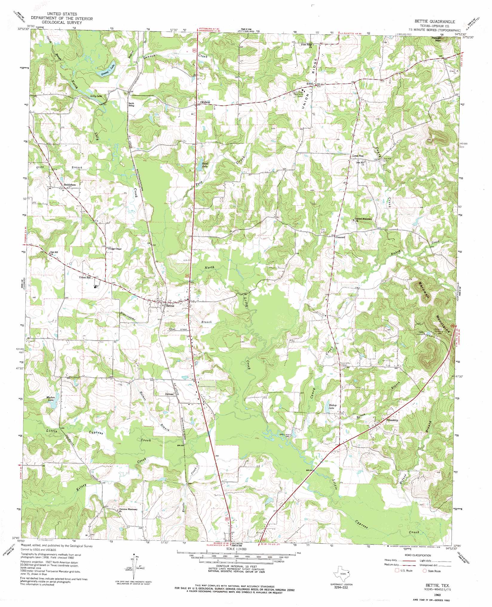
Bettie Topo Map Texas
To zoom in, hover over the map of Bettie
USGS Topo Quad 32094g8 - 1:24,000 scale
| Topo Map Name: | Bettie |
| USGS Topo Quad ID: | 32094g8 |
| Print Size: | ca. 21 1/4" wide x 27" high |
| Southeast Coordinates: | 32.75° N latitude / 94.875° W longitude |
| Map Center Coordinates: | 32.8125° N latitude / 94.9375° W longitude |
| U.S. State: | TX |
| Filename: | o32094g8.jpg |
| Download Map JPG Image: | Bettie topo map 1:24,000 scale |
| Map Type: | Topographic |
| Topo Series: | 7.5´ |
| Map Scale: | 1:24,000 |
| Source of Map Images: | United States Geological Survey (USGS) |
| Alternate Map Versions: |
Bettie TX 1960, updated 1962 Download PDF Buy paper map Bettie TX 1960, updated 1978 Download PDF Buy paper map Bettie TX 2010 Download PDF Buy paper map Bettie TX 2013 Download PDF Buy paper map Bettie TX 2016 Download PDF Buy paper map |
1:24,000 Topo Quads surrounding Bettie
New Hope |
Monticello |
Harvard |
Cason |
Daingerfield |
Newsome |
Leesburg |
Pittsburg |
Lafayette |
Lone Star |
Rhonesboro |
Thomas |
Bettie |
Coffeeville |
Ore City |
Shady Grove |
Pritchett |
Gilmer |
Glenwood |
Ashland |
Hawkins |
Big Sandy |
Gladewater |
White Oak |
Longview Heights |
> Back to 32094e1 at 1:100,000 scale
> Back to 32094a1 at 1:250,000 scale
> Back to U.S. Topo Maps home
Bettie topo map: Gazetteer
Bettie: Dams
Ewell Lake Dam elevation 102m 334′Machen Lake Dam elevation 93m 305′
Bettie: Lakes
Grassy Lake elevation 91m 298′Lilly Lake elevation 90m 295′
Bettie: Populated Places
Bethlehem elevation 109m 357′Bettie elevation 102m 334′
Concord elevation 112m 367′
Delrose elevation 109m 357′
Ewell elevation 128m 419′
Friendship elevation 108m 354′
Lone Pine elevation 121m 396′
Midway elevation 114m 374′
Union Hill elevation 113m 370′
Bettie: Reservoirs
Bishop Lake elevation 92m 301′Ewell Lake elevation 98m 321′
Machen Lake elevation 95m 311′
Bettie: Ridges
Union Ridge elevation 132m 433′Bettie: Streams
Belton Branch elevation 83m 272′Bishop Creek elevation 93m 305′
Blasingame Branch elevation 85m 278′
Brooks Creek elevation 85m 278′
Caney Creek elevation 83m 272′
Catfish Branch elevation 91m 298′
Denson Creek elevation 91m 298′
Hefner Branch elevation 80m 262′
Holmes Branch elevation 85m 278′
Hopkins Branch elevation 93m 305′
Kelsey Creek elevation 85m 278′
Lilly Creek elevation 84m 275′
Olive Branch elevation 90m 295′
Poor Creek elevation 88m 288′
Bettie digital topo map on disk
Buy this Bettie topo map showing relief, roads, GPS coordinates and other geographical features, as a high-resolution digital map file on DVD: