Kildare Topo Map Texas
To zoom in, hover over the map of Kildare
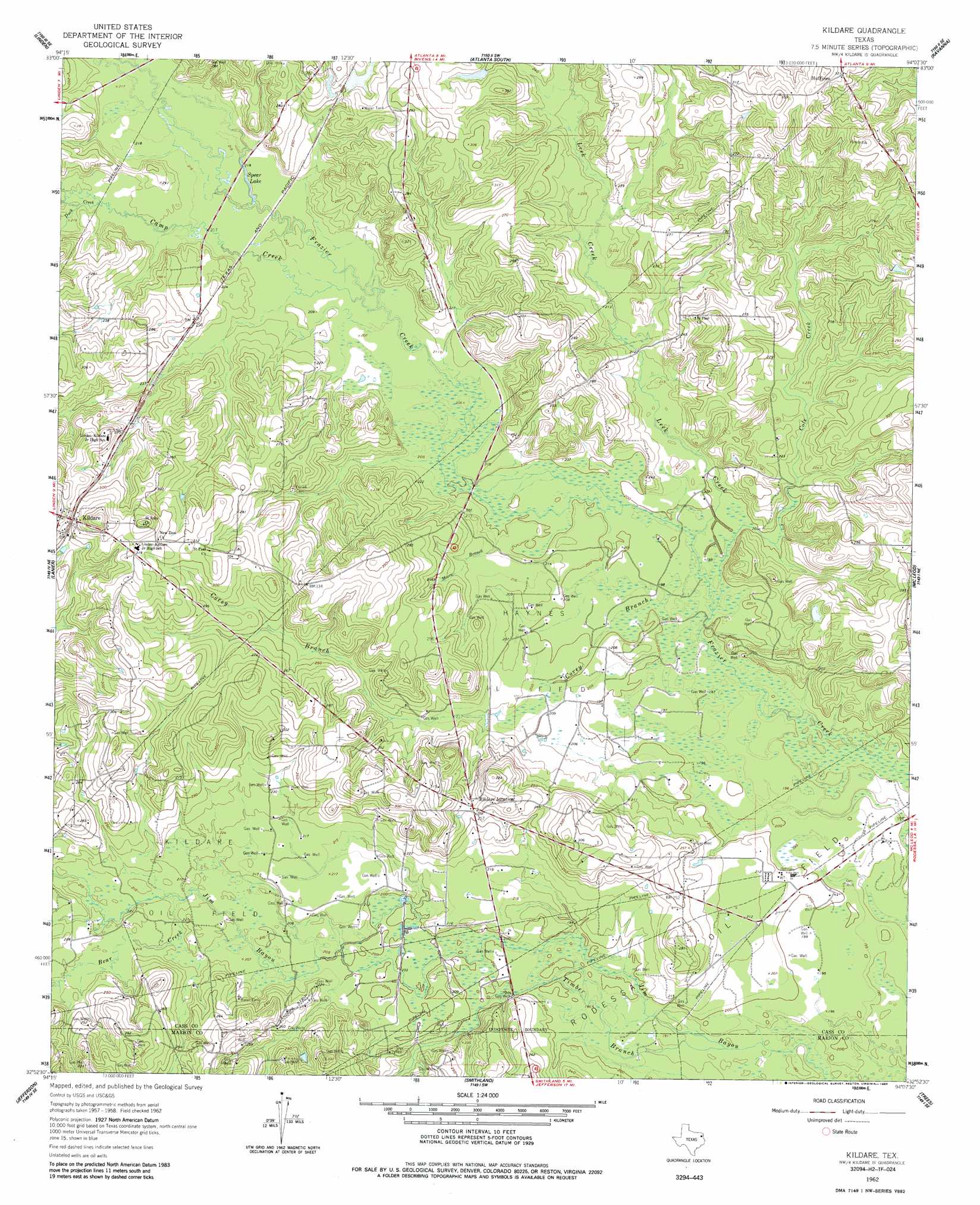
USGS Topo Quad 32094h2 - 1:24,000 scale
| Topo Map Name: | Kildare |
| USGS Topo Quad ID: | 32094h2 |
| Print Size: | ca. 21 1/4" wide x 27" high |
| Southeast Coordinates: | 32.875° N latitude / 94.125° W longitude |
| Map Center Coordinates: | 32.9375° N latitude / 94.1875° W longitude |
| U.S. State: | TX |
| Filename: | o32094h2.jpg |
| Download Map JPG Image: | Kildare topo map 1:24,000 scale |
| Map Type: | Topographic |
| Topo Series: | 7.5´ |
| Map Scale: | 1:24,000 |
| Source of Map Images: | United States Geological Survey (USGS) |
| Alternate Map Versions: |
Kildare TX 1962, updated 1963 Download PDF Buy paper map Kildare TX 1962, updated 1985 Download PDF Buy paper map Kildare TX 2010 Download PDF Buy paper map Kildare TX 2013 Download PDF Buy paper map Kildare TX 2016 Download PDF Buy paper map |
1:24,000 Topo Quads surrounding Kildare
Bryans Mill |
Douglassville |
Atlanta North |
Bloomburg |
Doddridge Nw |
Carterville |
Linden |
Atlanta South |
Ravanna |
Doddridge |
Cunningham Creek |
Lanier |
Kildare |
Mcleod |
Vivian North |
Kellyville |
Jefferson |
Smithland |
Trees |
Vivian South |
Marshall Nw |
Woodlawn |
Karnack |
Potters Point |
Mooringsport |
> Back to 32094e1 at 1:100,000 scale
> Back to 32094a1 at 1:250,000 scale
> Back to U.S. Topo Maps home
Kildare topo map: Gazetteer
Kildare: Dams
Grogan Dam elevation 78m 255′Kildare: Lakes
Spear Lake elevation 64m 209′Kildare: Oilfields
Haynes Oil Field elevation 64m 209′Kildare Oil Field elevation 64m 209′
Kildare: Populated Places
Huffins elevation 97m 318′Kildare elevation 96m 314′
Kildare Junction elevation 80m 262′
Kildare: Reservoirs
Grogan Lake elevation 78m 255′Kildare: Streams
Bear Creek elevation 62m 203′Camp Creek elevation 62m 203′
Cole Creek elevation 59m 193′
Corey Branch elevation 59m 193′
Duck Creek elevation 66m 216′
Leek Creek elevation 59m 193′
Moore Branch elevation 61m 200′
Timber Branch elevation 57m 187′
Kildare digital topo map on disk
Buy this Kildare topo map showing relief, roads, GPS coordinates and other geographical features, as a high-resolution digital map file on DVD: