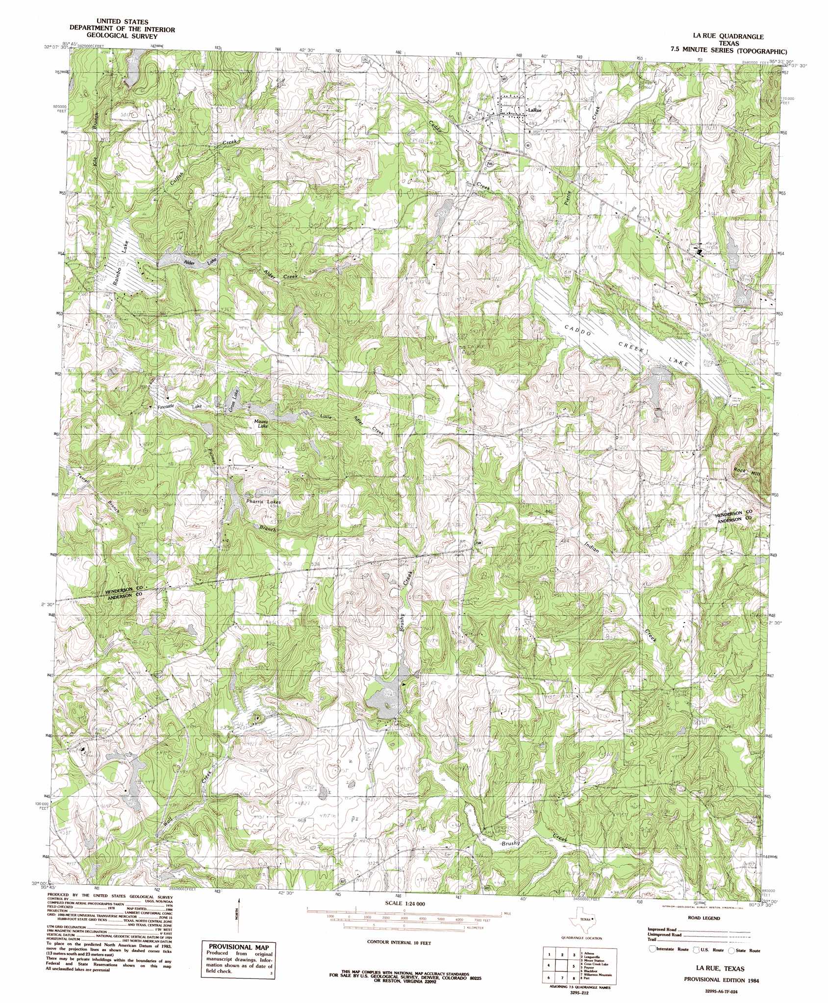
La Rue Topo Map Texas
To zoom in, hover over the map of La Rue
USGS Topo Quad 32095a6 - 1:24,000 scale
| Topo Map Name: | La Rue |
| USGS Topo Quad ID: | 32095a6 |
| Print Size: | ca. 21 1/4" wide x 27" high |
| Southeast Coordinates: | 32° N latitude / 95.625° W longitude |
| Map Center Coordinates: | 32.0625° N latitude / 95.6875° W longitude |
| U.S. State: | TX |
| Filename: | o32095a6.jpg |
| Download Map JPG Image: | La Rue topo map 1:24,000 scale |
| Map Type: | Topographic |
| Topo Series: | 7.5´ |
| Map Scale: | 1:24,000 |
| Source of Map Images: | United States Geological Survey (USGS) |
| Alternate Map Versions: |
La Rue TX 1984, updated 1984 Download PDF Buy paper map LaRue TX 2010 Download PDF Buy paper map LaRue TX 2012 Download PDF Buy paper map LaRue TX 2016 Download PDF Buy paper map |
1:24,000 Topo Quads surrounding La Rue
Stockard |
Murchinson West |
Murchinson East |
Brownsboro |
Chandler |
Mallard Hill |
Athens |
Leagueville |
Moore Station |
Saline Bay |
Cross Roads |
Coon Creek Lake |
La Rue |
Poynor |
Berryville |
Cayuga |
Blackfoot |
Wilkerson Mountain |
Pert |
Todd City |
Yard |
Tennessee Colony |
Northwest Palestine |
Northeast Palestine |
Neches |
> Back to 32095a1 at 1:100,000 scale
> Back to 32094a1 at 1:250,000 scale
> Back to U.S. Topo Maps home
La Rue topo map: Gazetteer
La Rue: Airports
Glad Oaks Airport elevation 149m 488′Meadowood Ranch Heliport elevation 159m 521′
La Rue: Dams
Alder Creek Dam elevation 115m 377′Caddo Creek Lake Dam elevation 130m 426′
Dennis Lake Dam elevation 140m 459′
Fincastle Lake Dam elevation 121m 396′
Grass Lake Dam elevation 122m 400′
Greenbrier Lake Dam elevation 115m 377′
Hallmark Lake Dam elevation 140m 459′
Horn Lake Dam elevation 120m 393′
Johns Lake Dam elevation 141m 462′
Lake CWM Dam elevation 131m 429′
Lake JDM Dam elevation 138m 452′
Lake Mawsy Dam elevation 130m 426′
Leo A Smith Lake Dam elevation 133m 436′
North Lake Dam elevation 141m 462′
Rainbo Lake Dam elevation 114m 374′
Site C Dam elevation 135m 442′
La Rue: Lakes
Pharris Lakes elevation 140m 459′La Rue: Populated Places
LaRue elevation 146m 479′La Rue: Reservoirs
Alder Creek Lake elevation 115m 377′Caddo Creek Lake elevation 130m 426′
Dennis Lake elevation 140m 459′
Fincastle Lake elevation 119m 390′
Grass Lake elevation 123m 403′
Greenbrier Lake elevation 115m 377′
Hallmark Lake elevation 140m 459′
Horn Lake elevation 120m 393′
Johns Lake elevation 141m 462′
Lake JDM elevation 138m 452′
Lake Mawsy elevation 130m 426′
Leo A Smith Lake elevation 133m 436′
North Lake elevation 141m 462′
Rainbo Lake elevation 114m 374′
Site C Reservoir elevation 135m 442′
La Rue: Streams
Alder Creek elevation 114m 374′Kile Branch elevation 114m 374′
Little Alder Creek elevation 109m 357′
Palmer Branch elevation 121m 396′
Pierce Creek elevation 130m 426′
La Rue: Summits
Rock Hill elevation 214m 702′La Rue digital topo map on disk
Buy this La Rue topo map showing relief, roads, GPS coordinates and other geographical features, as a high-resolution digital map file on DVD: