Coon Creek Lake Topo Map Texas
To zoom in, hover over the map of Coon Creek Lake
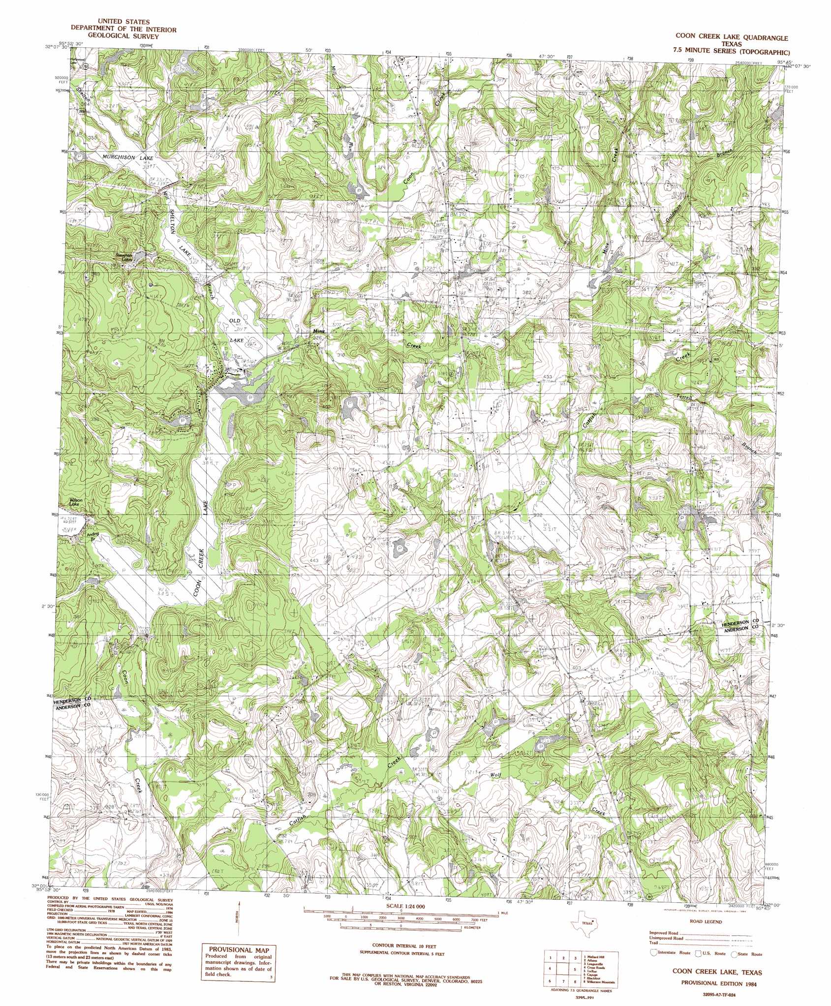
USGS Topo Quad 32095a7 - 1:24,000 scale
| Topo Map Name: | Coon Creek Lake |
| USGS Topo Quad ID: | 32095a7 |
| Print Size: | ca. 21 1/4" wide x 27" high |
| Southeast Coordinates: | 32° N latitude / 95.75° W longitude |
| Map Center Coordinates: | 32.0625° N latitude / 95.8125° W longitude |
| U.S. State: | TX |
| Filename: | o32095a7.jpg |
| Download Map JPG Image: | Coon Creek Lake topo map 1:24,000 scale |
| Map Type: | Topographic |
| Topo Series: | 7.5´ |
| Map Scale: | 1:24,000 |
| Source of Map Images: | United States Geological Survey (USGS) |
| Alternate Map Versions: |
Coon Creek Lake TX 1984, updated 1984 Download PDF Buy paper map Coon Creek Lake TX 2010 Download PDF Buy paper map Coon Creek Lake TX 2012 Download PDF Buy paper map Coon Creek Lake TX 2016 Download PDF Buy paper map |
1:24,000 Topo Quads surrounding Coon Creek Lake
Mabank |
Stockard |
Murchinson West |
Murchinson East |
Brownsboro |
Malakoff |
Mallard Hill |
Athens |
Leagueville |
Moore Station |
Creslenn Ranch |
Cross Roads |
Coon Creek Lake |
La Rue |
Poynor |
Roustabout Camp |
Cayuga |
Blackfoot |
Wilkerson Mountain |
Pert |
Young |
Yard |
Tennessee Colony |
Northwest Palestine |
Northeast Palestine |
> Back to 32095a1 at 1:100,000 scale
> Back to 32094a1 at 1:250,000 scale
> Back to U.S. Topo Maps home
Coon Creek Lake topo map: Gazetteer
Coon Creek Lake: Dams
Black Lake Dam elevation 99m 324′Cartwright Dam elevation 101m 331′
Catfish Creek Ranch Lake Dam elevation 104m 341′
Koon Kreek Lake Dam elevation 94m 308′
Lucky Lake Dam elevation 106m 347′
Lunceford Lake Dam elevation 102m 334′
Murchison Lake Dam elevation 109m 357′
Old Lake Dam elevation 95m 311′
Shelton Lake Dam elevation 99m 324′
Slaughter Lake Number 1 Dam elevation 102m 334′
Soutter Lake Dam elevation 121m 396′
Stroube Dam Number 1 elevation 113m 370′
Terra Verda Lake Dam elevation 104m 341′
Wilson Lake Dam elevation 101m 331′
Coon Creek Lake: Reservoirs
Black Lake elevation 99m 324′Cartwright Lake elevation 101m 331′
Catfish Creek Ranch Lake elevation 104m 341′
Coon Creek Lake elevation 91m 298′
Koon Kreek Lake elevation 94m 308′
Lucky Lake elevation 106m 347′
Lunceford Lake elevation 102m 334′
Murchison Lake elevation 103m 337′
Murchison Lake elevation 109m 357′
Old Lake elevation 95m 311′
Old Lake elevation 95m 311′
Shelton Lake elevation 99m 324′
Slaughter Lakes elevation 102m 334′
Soutter Lake elevation 121m 396′
Stroube Lake Number 1 elevation 113m 370′
Terra Verda Lake elevation 104m 341′
Wilson Lake elevation 101m 331′
Coon Creek Lake: Streams
Goldman Branch elevation 103m 337′Mine Creek elevation 95m 311′
Pickle Branch elevation 101m 331′
Shelton Mill Branch elevation 96m 314′
Terrell Branch elevation 103m 337′
Wolf Creek elevation 92m 301′
Coon Creek Lake: Summits
Pine Grove Hill elevation 151m 495′Coon Creek Lake digital topo map on disk
Buy this Coon Creek Lake topo map showing relief, roads, GPS coordinates and other geographical features, as a high-resolution digital map file on DVD: