Troup West Topo Map Texas
To zoom in, hover over the map of Troup West
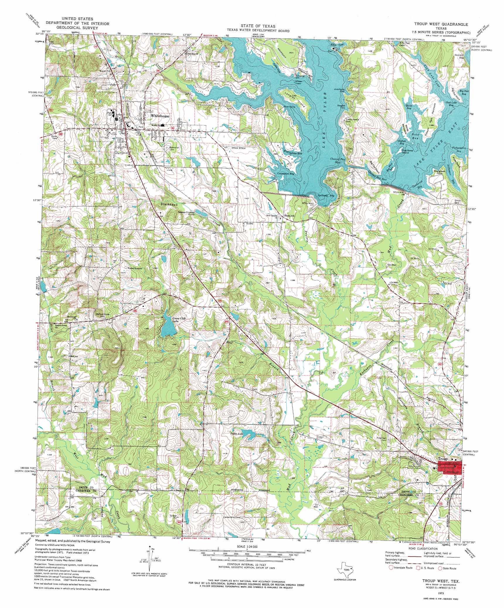
USGS Topo Quad 32095b2 - 1:24,000 scale
| Topo Map Name: | Troup West |
| USGS Topo Quad ID: | 32095b2 |
| Print Size: | ca. 21 1/4" wide x 27" high |
| Southeast Coordinates: | 32.125° N latitude / 95.125° W longitude |
| Map Center Coordinates: | 32.1875° N latitude / 95.1875° W longitude |
| U.S. State: | TX |
| Filename: | o32095b2.jpg |
| Download Map JPG Image: | Troup West topo map 1:24,000 scale |
| Map Type: | Topographic |
| Topo Series: | 7.5´ |
| Map Scale: | 1:24,000 |
| Source of Map Images: | United States Geological Survey (USGS) |
| Alternate Map Versions: |
Troup West TX 1973, updated 1976 Download PDF Buy paper map Troup West TX 1973, updated 1976 Download PDF Buy paper map Troup West TX 2010 Download PDF Buy paper map Troup West TX 2012 Download PDF Buy paper map Troup West TX 2016 Download PDF Buy paper map |
1:24,000 Topo Quads surrounding Troup West
Mount Sylvan |
Tyler North |
Winona |
Starrville |
Kilgore Nw |
Chandler |
Tyler South |
Bascom |
Hope Pond |
Kilgore Sw |
Saline Bay |
Bullard |
Troup West |
Troup East |
Price |
Berryville |
Mount Selman |
Tecula |
Griffin |
Gum Springs |
Todd City |
Jacksonville West |
Jacksonville East |
New Summerfield |
New Salem |
> Back to 32095a1 at 1:100,000 scale
> Back to 32094a1 at 1:250,000 scale
> Back to U.S. Topo Maps home
Troup West topo map: Gazetteer
Troup West: Airports
Nuttall Airport elevation 129m 423′Troup West: Bays
Allen Cove elevation 115m 377′Aplin Cove elevation 119m 390′
Arterberry Cove elevation 116m 380′
Bass Bay elevation 115m 377′
Big Flat Bay elevation 115m 377′
Catfish Bay elevation 115m 377′
Channel Bay East elevation 115m 377′
Channel Bay West elevation 115m 377′
Club Lake Bay elevation 115m 377′
Club Lake Cove elevation 115m 377′
Concession Bay elevation 115m 377′
Douglas Cove elevation 118m 387′
Fishermans Bay elevation 115m 377′
Gunbarrel Bay elevation 115m 377′
Quiet Bay elevation 115m 377′
Sawmill Bay elevation 115m 377′
Spillway Bay elevation 115m 377′
Stillwater Bay elevation 115m 377′
Willingham Bay elevation 115m 377′
Troup West: Capes
Big Flat Point elevation 120m 393′Big Oak Point elevation 116m 380′
Chapman Point elevation 115m 377′
Evergreen Point elevation 116m 380′
Piney Point elevation 118m 387′
Possun Park Peninsula elevation 116m 380′
Windy Peninsula elevation 116m 380′
Troup West: Dams
Dodds Lake Dam elevation 112m 367′Grove Club Dam elevation 112m 367′
Mud Creek Dam elevation 103m 337′
Whitehouse Dam elevation 115m 377′
Troup West: Islands
Dog Bone Island elevation 115m 377′Langley Island elevation 117m 383′
Troup West: Parks
Concesion Park elevation 117m 383′Hill Creek Park elevation 123m 403′
Sandy Beach Park elevation 122m 400′
Whitehouse Park elevation 122m 400′
Troup West: Populated Places
Blackjack elevation 112m 367′Whitehouse elevation 146m 479′
Troup West: Reservoirs
Arp Club Lake elevation 116m 380′Dodds Lake elevation 107m 351′
Grove Club Lake elevation 116m 380′
Lake Tyler elevation 115m 377′
Lake Tyler East elevation 115m 377′
Lake Tyler-East elevation 103m 337′
Troup West: Streams
Bell Branch elevation 97m 318′Blackhawk Creek elevation 101m 331′
Brier Branch elevation 104m 341′
Gilley Creek elevation 115m 377′
Hill Creek elevation 115m 377′
Horsepen Branch elevation 101m 331′
Kickapoo Creek elevation 99m 324′
Prairie Creek elevation 100m 328′
Troup West digital topo map on disk
Buy this Troup West topo map showing relief, roads, GPS coordinates and other geographical features, as a high-resolution digital map file on DVD: