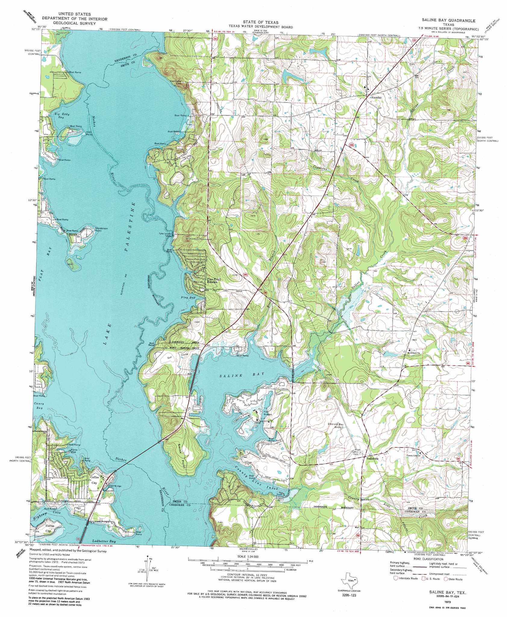
Saline Bay Topo Map Texas
To zoom in, hover over the map of Saline Bay
USGS Topo Quad 32095b4 - 1:24,000 scale
| Topo Map Name: | Saline Bay |
| USGS Topo Quad ID: | 32095b4 |
| Print Size: | ca. 21 1/4" wide x 27" high |
| Southeast Coordinates: | 32.125° N latitude / 95.375° W longitude |
| Map Center Coordinates: | 32.1875° N latitude / 95.4375° W longitude |
| U.S. State: | TX |
| Filename: | o32095b4.jpg |
| Download Map JPG Image: | Saline Bay topo map 1:24,000 scale |
| Map Type: | Topographic |
| Topo Series: | 7.5´ |
| Map Scale: | 1:24,000 |
| Source of Map Images: | United States Geological Survey (USGS) |
| Alternate Map Versions: |
Saline Bay TX 1973, updated 1976 Download PDF Buy paper map Saline Bay TX 1973, updated 1987 Download PDF Buy paper map Saline Bay TX 1973, updated 1987 Download PDF Buy paper map Saline Bay TX 2010 Download PDF Buy paper map Saline Bay TX 2012 Download PDF Buy paper map Saline Bay TX 2016 Download PDF Buy paper map |
1:24,000 Topo Quads surrounding Saline Bay
Ben Wheeler |
Carroll |
Mount Sylvan |
Tyler North |
Winona |
Murchinson East |
Brownsboro |
Chandler |
Tyler South |
Bascom |
Leagueville |
Moore Station |
Saline Bay |
Bullard |
Troup West |
La Rue |
Poynor |
Berryville |
Mount Selman |
Tecula |
Wilkerson Mountain |
Pert |
Todd City |
Jacksonville West |
Jacksonville East |
> Back to 32095a1 at 1:100,000 scale
> Back to 32094a1 at 1:250,000 scale
> Back to U.S. Topo Maps home
Saline Bay topo map: Gazetteer
Saline Bay: Airports
Emerald Bay Airport elevation 122m 400′Saline Bay: Bays
Big Eddy Bay elevation 105m 344′Caney Bay elevation 105m 344′
County Line Inlet elevation 105m 344′
Flag Bay elevation 105m 344′
Flat Bay elevation 105m 344′
Highsaw Cove elevation 105m 344′
Saline Bay elevation 105m 344′
Saline Bay: Capes
Henderson Point elevation 107m 351′Holt Point elevation 105m 344′
Smith Point elevation 122m 400′
Saline Bay: Dams
Brookshire Lake Dam elevation 134m 439′Tom Clay Lake Dam elevation 134m 439′
Saline Bay: Populated Places
Dogwood City elevation 119m 390′Noonday elevation 142m 465′
Pine Trail Estates elevation 119m 390′
Teaselville elevation 127m 416′
Saline Bay: Reservoirs
Brookshire Lake elevation 134m 439′Tom Clay Lake elevation 134m 439′
Saline Bay: Springs
Cherokee Springs elevation 105m 344′Saline Bay: Streams
Caney Creek elevation 105m 344′Copperas Creek elevation 111m 364′
County Line Creek elevation 105m 344′
Flat Creek elevation 105m 344′
Rose Branch elevation 106m 347′
Saline Creek elevation 105m 344′
Saline Bay digital topo map on disk
Buy this Saline Bay topo map showing relief, roads, GPS coordinates and other geographical features, as a high-resolution digital map file on DVD: