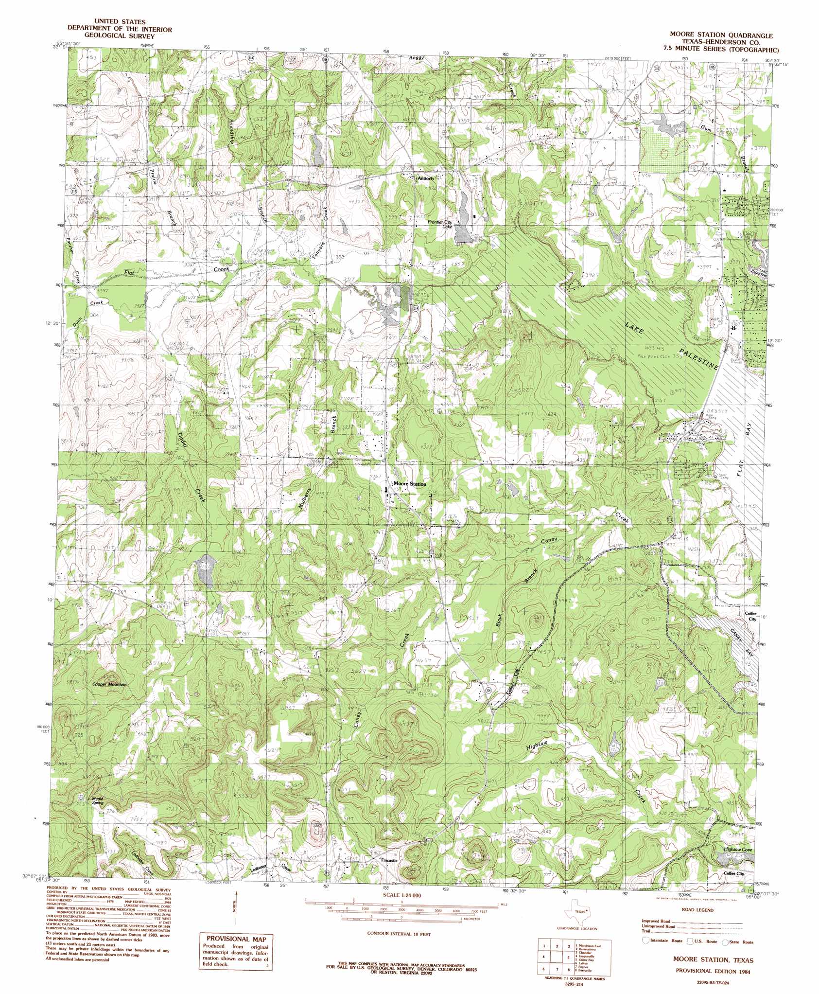
Moore Station Topo Map Texas
To zoom in, hover over the map of Moore Station
USGS Topo Quad 32095b5 - 1:24,000 scale
| Topo Map Name: | Moore Station |
| USGS Topo Quad ID: | 32095b5 |
| Print Size: | ca. 21 1/4" wide x 27" high |
| Southeast Coordinates: | 32.125° N latitude / 95.5° W longitude |
| Map Center Coordinates: | 32.1875° N latitude / 95.5625° W longitude |
| U.S. State: | TX |
| Filename: | o32095b5.jpg |
| Download Map JPG Image: | Moore Station topo map 1:24,000 scale |
| Map Type: | Topographic |
| Topo Series: | 7.5´ |
| Map Scale: | 1:24,000 |
| Source of Map Images: | United States Geological Survey (USGS) |
| Alternate Map Versions: |
Moore Station TX 1984, updated 1984 Download PDF Buy paper map Moore Station TX 2010 Download PDF Buy paper map Moore Station TX 2013 Download PDF Buy paper map Moore Station TX 2016 Download PDF Buy paper map |
1:24,000 Topo Quads surrounding Moore Station
Martins Mill |
Ben Wheeler |
Carroll |
Mount Sylvan |
Tyler North |
Murchinson West |
Murchinson East |
Brownsboro |
Chandler |
Tyler South |
Athens |
Leagueville |
Moore Station |
Saline Bay |
Bullard |
Coon Creek Lake |
La Rue |
Poynor |
Berryville |
Mount Selman |
Blackfoot |
Wilkerson Mountain |
Pert |
Todd City |
Jacksonville West |
> Back to 32095a1 at 1:100,000 scale
> Back to 32094a1 at 1:250,000 scale
> Back to U.S. Topo Maps home
Moore Station topo map: Gazetteer
Moore Station: Dams
Bagley Lake Dam elevation 120m 393′Frontier City Lake Dam elevation 110m 360′
Kidd Lake Dam elevation 127m 416′
Rodgers Lake Dam elevation 119m 390′
Tex Iron Incorporated Dam Number 1 elevation 186m 610′
Tex Iron Incorporated Dam Number 2 elevation 218m 715′
Moore Station: Lakes
Frontier City Lake elevation 114m 374′Hurts Lake elevation 119m 390′
Moore Station: Populated Places
Antioch elevation 138m 452′Fincastle elevation 153m 501′
Moore Station elevation 128m 419′
Moore Station: Reservoirs
Bagley Lake elevation 120m 393′Frontier City Lake elevation 110m 360′
Kidd Lake elevation 127m 416′
Rodgers Lake elevation 119m 390′
Tex Iron Incorporated Reservoir Number 1 elevation 186m 610′
Tex Iron Incorporated Reservoir Number 2 elevation 218m 715′
Moore Station: Springs
Moore Spring elevation 215m 705′Moore Station: Streams
Boggy Creek elevation 105m 344′Dunn Creek elevation 109m 357′
Friendship Branch elevation 109m 357′
Gum Branch elevation 105m 344′
Highsaw Creek elevation 106m 347′
Mulberry Branch elevation 107m 351′
Panther Creek elevation 109m 357′
Putegnat School elevation 108m 354′
Tindel Creek elevation 109m 357′
Tonyard Creek elevation 109m 357′
Moore Station: Summits
Cooper Mountain elevation 192m 629′Moore Station: Swamps
Anderson Marsh elevation 119m 390′Moore Station digital topo map on disk
Buy this Moore Station topo map showing relief, roads, GPS coordinates and other geographical features, as a high-resolution digital map file on DVD: