Tyler South Topo Map Texas
To zoom in, hover over the map of Tyler South
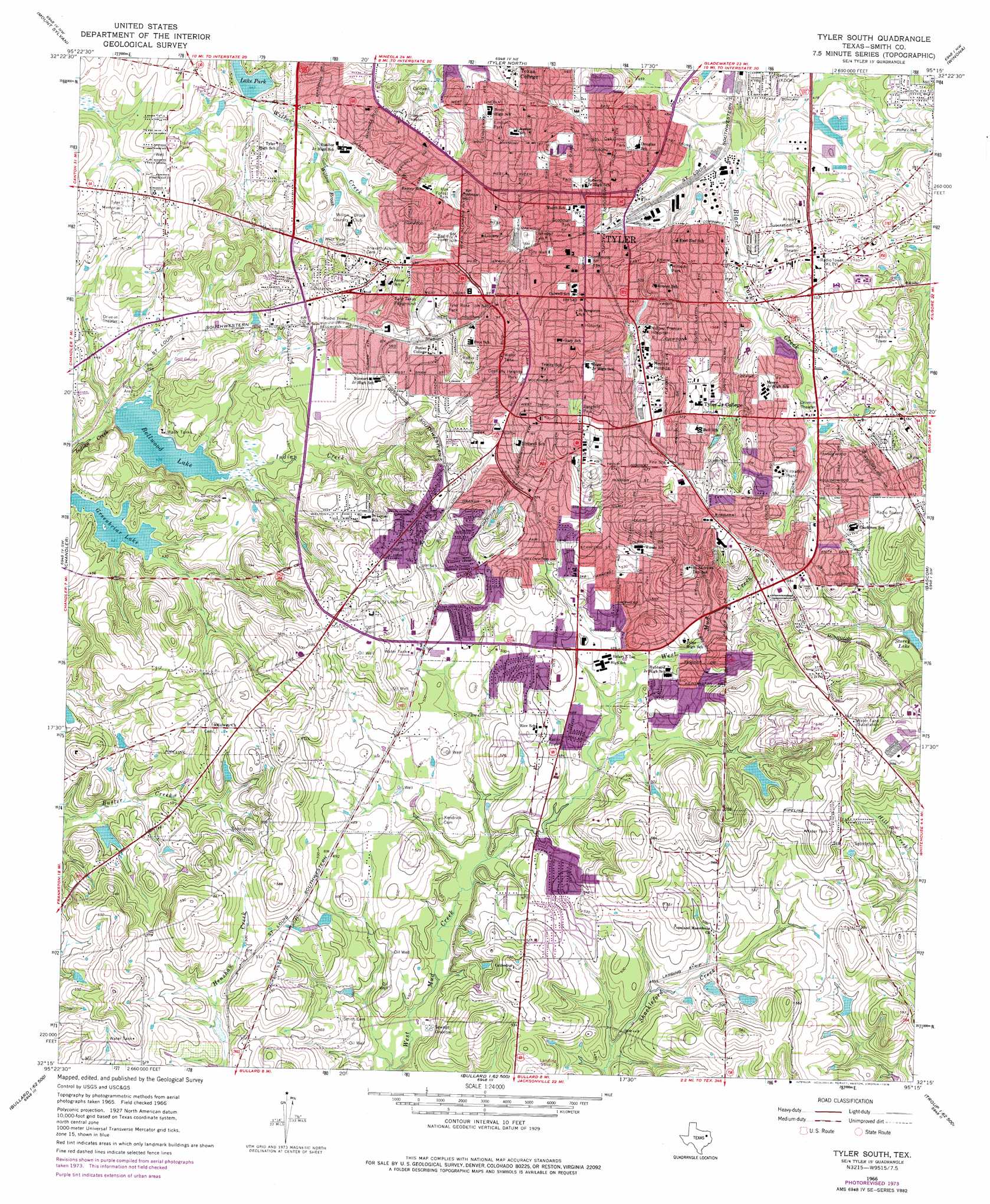
USGS Topo Quad 32095c3 - 1:24,000 scale
| Topo Map Name: | Tyler South |
| USGS Topo Quad ID: | 32095c3 |
| Print Size: | ca. 21 1/4" wide x 27" high |
| Southeast Coordinates: | 32.25° N latitude / 95.25° W longitude |
| Map Center Coordinates: | 32.3125° N latitude / 95.3125° W longitude |
| U.S. State: | TX |
| Filename: | o32095c3.jpg |
| Download Map JPG Image: | Tyler South topo map 1:24,000 scale |
| Map Type: | Topographic |
| Topo Series: | 7.5´ |
| Map Scale: | 1:24,000 |
| Source of Map Images: | United States Geological Survey (USGS) |
| Alternate Map Versions: |
Tyler South TX 1966, updated 1970 Download PDF Buy paper map Tyler South TX 1966, updated 1976 Download PDF Buy paper map Tyler South TX 1966, updated 1976 Download PDF Buy paper map Tyler South TX 2010 Download PDF Buy paper map Tyler South TX 2012 Download PDF Buy paper map Tyler South TX 2016 Download PDF Buy paper map |
1:24,000 Topo Quads surrounding Tyler South
Van Lake |
Lindale |
Crow |
Hawkins |
Big Sandy |
Carroll |
Mount Sylvan |
Tyler North |
Winona |
Starrville |
Brownsboro |
Chandler |
Tyler South |
Bascom |
Hope Pond |
Moore Station |
Saline Bay |
Bullard |
Troup West |
Troup East |
Poynor |
Berryville |
Mount Selman |
Tecula |
Griffin |
> Back to 32095a1 at 1:100,000 scale
> Back to 32094a1 at 1:250,000 scale
> Back to U.S. Topo Maps home
Tyler South topo map: Gazetteer
Tyler South: Airports
Medical Center Hospital Heliport elevation 172m 564′Mother Frances Hospital Heliport elevation 166m 544′
Tyler South: Dams
Bellwood Lake Dam elevation 134m 439′Lower Lake Dam elevation 174m 570′
Tyler Hydraulic-Fill Dam elevation 132m 433′
West Mud Creek Lake Dam elevation 155m 508′
Tyler South: Parks
Bergfeld Park elevation 174m 570′Connally Heights Park elevation 181m 593′
Fun Forest Park elevation 174m 570′
Gassaway Park elevation 150m 492′
Golden Park elevation 172m 564′
Goodman Park elevation 160m 524′
Hillside Park elevation 148m 485′
Lincoln Park elevation 159m 521′
Oak Grove Park elevation 155m 508′
Old Grape Park elevation 155m 508′
Peach Avenue Park elevation 175m 574′
Pollard Park elevation 162m 531′
Rose Stadium elevation 175m 574′
Southside Park elevation 145m 475′
T K Gorman Catholic School Baseball Field elevation 149m 488′
T K Gorman Catholic School Football Field elevation 152m 498′
Tyler Rose Park elevation 163m 534′
Tyler Rose Stadium elevation 166m 544′
Tyler South: Populated Places
Tyler elevation 164m 538′Tyler South: Reservoirs
Bellwood Lake elevation 130m 426′Greenbriar Lake elevation 128m 419′
Lower Lake elevation 174m 570′
Storey Lake elevation 148m 485′
West Mud Creek Lake elevation 155m 508′
Tyler South: Springs
Arms Factory Spring elevation 173m 567′Neff Springs elevation 171m 561′
Tyler Springs elevation 168m 551′
Tyler South: Streams
Willow Brook elevation 137m 449′Tyler South: Trails
Southside Park Trail elevation 146m 479′Tyler South digital topo map on disk
Buy this Tyler South topo map showing relief, roads, GPS coordinates and other geographical features, as a high-resolution digital map file on DVD: