Mineola Topo Map Texas
To zoom in, hover over the map of Mineola
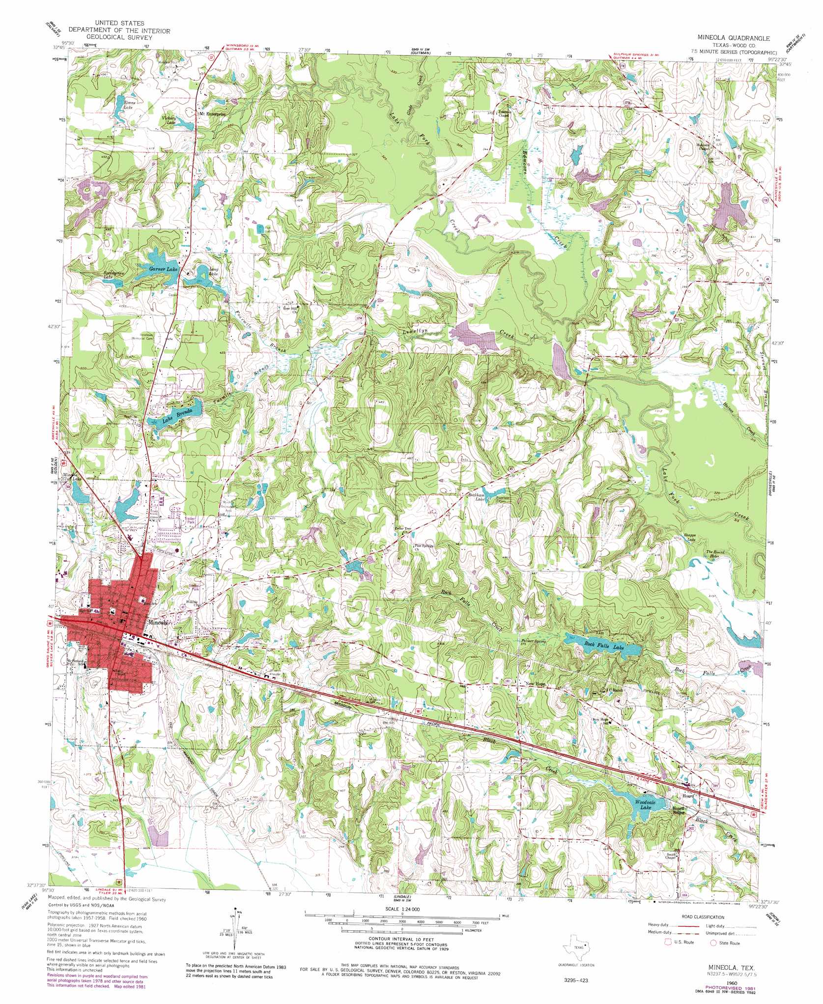
USGS Topo Quad 32095f4 - 1:24,000 scale
| Topo Map Name: | Mineola |
| USGS Topo Quad ID: | 32095f4 |
| Print Size: | ca. 21 1/4" wide x 27" high |
| Southeast Coordinates: | 32.625° N latitude / 95.375° W longitude |
| Map Center Coordinates: | 32.6875° N latitude / 95.4375° W longitude |
| U.S. State: | TX |
| Filename: | o32095f4.jpg |
| Download Map JPG Image: | Mineola topo map 1:24,000 scale |
| Map Type: | Topographic |
| Topo Series: | 7.5´ |
| Map Scale: | 1:24,000 |
| Source of Map Images: | United States Geological Survey (USGS) |
| Alternate Map Versions: |
Mineola TX 1960, updated 1962 Download PDF Buy paper map Mineola TX 1960, updated 1982 Download PDF Buy paper map Mineola TX 2010 Download PDF Buy paper map Mineola TX 2012 Download PDF Buy paper map Mineola TX 2016 Download PDF Buy paper map |
1:24,000 Topo Quads surrounding Mineola
Arbala |
Yantis |
Pleasant Grove |
Winnsboro |
Newsome |
Alba |
Calvary |
Quitman |
Cartwright |
Rhonesboro |
Grand Saline |
Golden |
Mineola |
Hainesville |
Shady Grove |
Van |
Van Lake |
Lindale |
Crow |
Hawkins |
Ben Wheeler |
Carroll |
Mount Sylvan |
Tyler North |
Winona |
> Back to 32095e1 at 1:100,000 scale
> Back to 32094a1 at 1:250,000 scale
> Back to U.S. Topo Maps home
Mineola topo map: Gazetteer
Mineola: Airports
Mineola-Quitman Airport elevation 127m 416′Rhodes Ranch Airport elevation 124m 406′
Mineola: Dams
Adkins Lake Dam elevation 126m 413′Garner Dam elevation 119m 390′
Lake Brenda Dam elevation 124m 406′
Long Lake Dam elevation 117m 383′
Mineola Club Dam elevation 117m 383′
Rock Falls Dam elevation 114m 374′
Sundowner Lake Dam elevation 115m 377′
Woodvale Dam elevation 109m 357′
Mineola: Lakes
Shapps Lake elevation 95m 311′The Round Holes elevation 94m 308′
Mineola: Parks
Meredith Memorial Field elevation 130m 426′Mineola Recreation Area elevation 133m 436′
Mineola: Populated Places
Hoard elevation 118m 387′Mineola elevation 127m 416′
New Hope elevation 131m 429′
Mineola: Reservoirs
Adkins Lake elevation 126m 413′Beckham Lake elevation 124m 406′
Evans Lake elevation 120m 393′
Garner Lake elevation 122m 400′
Lake Brenda elevation 123m 403′
Long Lake elevation 117m 383′
Mineola Club Lake elevation 120m 393′
Rock Falls Lake elevation 112m 367′
Springview Lake elevation 128m 419′
Sundowner Lake elevation 115m 377′
Vickory Lake elevation 113m 370′
Woodvale Lake elevation 109m 357′
Mineola: Springs
Palmer Spring elevation 114m 374′Mineola: Streams
Edmoore Creek elevation 96m 314′Fourmile Branch elevation 105m 344′
Glade Creek elevation 97m 318′
Lewellyn Creek elevation 94m 308′
Stewart Branch elevation 94m 308′
Twomile Branch elevation 108m 354′
Mineola digital topo map on disk
Buy this Mineola topo map showing relief, roads, GPS coordinates and other geographical features, as a high-resolution digital map file on DVD: