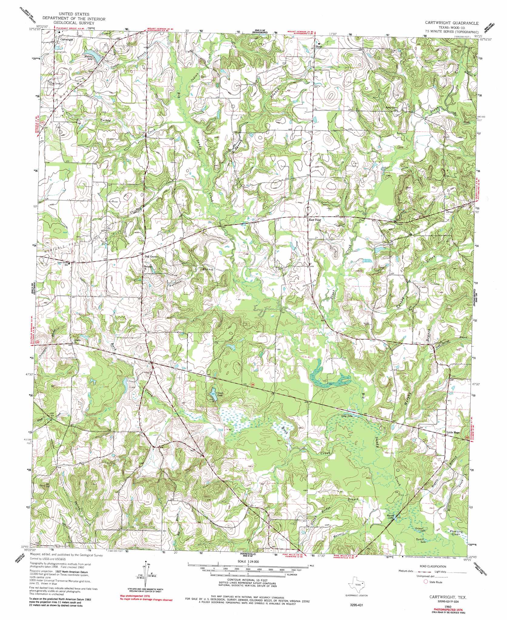
Cartwright Topo Map Texas
To zoom in, hover over the map of Cartwright
USGS Topo Quad 32095g3 - 1:24,000 scale
| Topo Map Name: | Cartwright |
| USGS Topo Quad ID: | 32095g3 |
| Print Size: | ca. 21 1/4" wide x 27" high |
| Southeast Coordinates: | 32.75° N latitude / 95.25° W longitude |
| Map Center Coordinates: | 32.8125° N latitude / 95.3125° W longitude |
| U.S. State: | TX |
| Filename: | o32095g3.jpg |
| Download Map JPG Image: | Cartwright topo map 1:24,000 scale |
| Map Type: | Topographic |
| Topo Series: | 7.5´ |
| Map Scale: | 1:24,000 |
| Source of Map Images: | United States Geological Survey (USGS) |
| Alternate Map Versions: |
Cartwright TX 1960, updated 1962 Download PDF Buy paper map Cartwright TX 1960, updated 1985 Download PDF Buy paper map Cartwright TX 2010 Download PDF Buy paper map Cartwright TX 2012 Download PDF Buy paper map Cartwright TX 2016 Download PDF Buy paper map |
1:24,000 Topo Quads surrounding Cartwright
Sulphur Springs Se |
Como |
Purley |
New Hope |
Monticello |
Yantis |
Pleasant Grove |
Winnsboro |
Newsome |
Leesburg |
Calvary |
Quitman |
Cartwright |
Rhonesboro |
Thomas |
Golden |
Mineola |
Hainesville |
Shady Grove |
Pritchett |
Van Lake |
Lindale |
Crow |
Hawkins |
Big Sandy |
> Back to 32095e1 at 1:100,000 scale
> Back to 32094a1 at 1:250,000 scale
> Back to U.S. Topo Maps home
Cartwright topo map: Gazetteer
Cartwright: Dams
Big Woods Spring Lake Dam elevation 134m 439′Midway Lake Dam elevation 144m 472′
Cartwright: Lakes
Grinnel Lake elevation 105m 344′Long Lake elevation 108m 354′
Round Lake elevation 106m 347′
Tarkill Lake elevation 105m 344′
Cartwright: Oilfields
Way Lake Oil Field elevation 144m 472′Cartwright: Populated Places
Cartwright elevation 142m 465′East Point elevation 136m 446′
Little Hope elevation 126m 413′
Oak Grove elevation 147m 482′
Stout elevation 140m 459′
Cartwright: Reservoirs
Big Woods Spring Lake elevation 134m 439′Crones Pond elevation 120m 393′
Midway Lake elevation 135m 442′
Cartwright: Streams
Buck Creek elevation 106m 347′Burleson Branch elevation 113m 370′
Chicken Creek elevation 115m 377′
Cooper Branch elevation 119m 390′
Homebrew Branch elevation 124m 406′
Indian Creek elevation 118m 387′
Jarred Branch elevation 116m 380′
Mansell Creek elevation 105m 344′
Mill Creek elevation 122m 400′
Murphy Branch elevation 106m 347′
Rogers Branch elevation 104m 341′
Sand Springs Branch elevation 120m 393′
Slough Bridge Branch elevation 106m 347′
Stout Creek elevation 110m 360′
Turkey Creek elevation 118m 387′
Turkey Creek elevation 112m 367′
Cartwright digital topo map on disk
Buy this Cartwright topo map showing relief, roads, GPS coordinates and other geographical features, as a high-resolution digital map file on DVD: