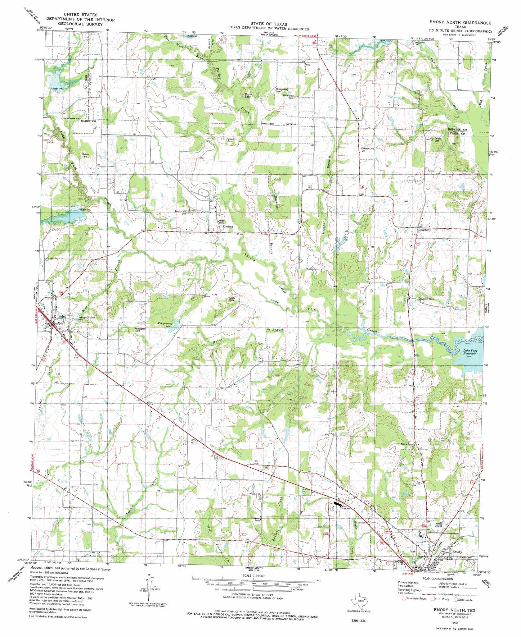
Emory North Topo Map Texas
To zoom in, hover over the map of Emory North
USGS Topo Quad 32095h7 - 1:24,000 scale
| Topo Map Name: | Emory North |
| USGS Topo Quad ID: | 32095h7 |
| Print Size: | ca. 21 1/4" wide x 27" high |
| Southeast Coordinates: | 32.875° N latitude / 95.75° W longitude |
| Map Center Coordinates: | 32.9375° N latitude / 95.8125° W longitude |
| U.S. State: | TX |
| Filename: | o32095h7.jpg |
| Download Map JPG Image: | Emory North topo map 1:24,000 scale |
| Map Type: | Topographic |
| Topo Series: | 7.5´ |
| Map Scale: | 1:24,000 |
| Source of Map Images: | United States Geological Survey (USGS) |
| Alternate Map Versions: |
Emory North TX 1980, updated 1980 Download PDF Buy paper map Emory North TX 2010 Download PDF Buy paper map Emory North TX 2012 Download PDF Buy paper map Emory North TX 2016 Download PDF Buy paper map |
1:24,000 Topo Quads surrounding Emory North
Greenville Ne |
Commerce South |
Cumby |
Gafford Chapel |
Sulphur Springs |
Greenville Se |
Lone Oak North |
Miller Grove |
Brashear |
Sulphur Springs Se |
West Tawakoni |
Lone Oak South |
Emory North |
Arbala |
Yantis |
Ables Springs |
Iron Bridge Dam |
Emory South |
Alba |
Calvary |
Wills Point |
Edgewood |
Fruitvale |
Grand Saline |
Golden |
> Back to 32095e1 at 1:100,000 scale
> Back to 32094a1 at 1:250,000 scale
> Back to U.S. Topo Maps home
Emory North topo map: Gazetteer
Emory North: Dams
Dam Nine elevation 143m 469′Dam Twentytwo elevation 136m 446′
Montgomery Lake Dam elevation 145m 475′
Soil Conservation Service Site 22 Dam elevation 134m 439′
Soil Conservation Service Site 7 Dam elevation 146m 479′
Soil Conservation Service Site 9 Dam elevation 137m 449′
T Dam 7 elevation 147m 482′
Emory North: Lakes
Burns Lake elevation 134m 439′Emory North: Populated Places
County Line elevation 150m 492′Dougherty elevation 142m 465′
Point elevation 161m 528′
Prospect elevation 155m 508′
Richland elevation 139m 456′
Richland elevation 140m 459′
Emory North: Reservoirs
Montgomery Lake elevation 145m 475′Soil Conservation Service Site 22 Reservoir elevation 134m 439′
Soil Conservation Service Site 7 Reservoir elevation 146m 479′
Soil Conservation Service Site 9 Reservoir elevation 137m 449′
Emory North: Streams
Brickkiln Branch elevation 137m 449′Buckeye Branch elevation 128m 419′
Dement Branch elevation 124m 406′
Mitcham Branch elevation 137m 449′
Moss Wash Branch elevation 137m 449′
Rains Branch elevation 123m 403′
Rice Branch elevation 134m 439′
Slough Creek elevation 137m 449′
Turkey Creek elevation 128m 419′
Emory North digital topo map on disk
Buy this Emory North topo map showing relief, roads, GPS coordinates and other geographical features, as a high-resolution digital map file on DVD: