Corbet Topo Map Texas
To zoom in, hover over the map of Corbet
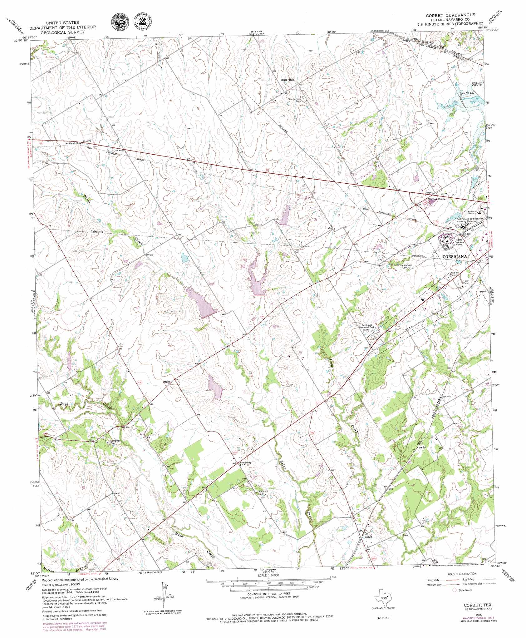
USGS Topo Quad 32096a5 - 1:24,000 scale
| Topo Map Name: | Corbet |
| USGS Topo Quad ID: | 32096a5 |
| Print Size: | ca. 21 1/4" wide x 27" high |
| Southeast Coordinates: | 32° N latitude / 96.5° W longitude |
| Map Center Coordinates: | 32.0625° N latitude / 96.5625° W longitude |
| U.S. State: | TX |
| Filename: | o32096a5.jpg |
| Download Map JPG Image: | Corbet topo map 1:24,000 scale |
| Map Type: | Topographic |
| Topo Series: | 7.5´ |
| Map Scale: | 1:24,000 |
| Source of Map Images: | United States Geological Survey (USGS) |
| Alternate Map Versions: |
Corbet TX 1965, updated 1967 Download PDF Buy paper map Corbet TX 1965, updated 1979 Download PDF Buy paper map Corbet TX 2010 Download PDF Buy paper map Corbet TX 2012 Download PDF Buy paper map Corbet TX 2016 Download PDF Buy paper map |
1:24,000 Topo Quads surrounding Corbet
Forreston |
Ennis West |
Ennis East |
Rosser Sw |
Styx |
Avalon |
Cryer Creek |
Emhouse |
Chatfield |
Bazette |
Frost |
Blooming Grove |
Corbet |
Corsicana |
Powell |
Irene |
Dawson |
Purdon |
Richland |
Streetman |
Hubbard |
Coolidge |
Union High |
Wortham |
Kirvin |
> Back to 32096a1 at 1:100,000 scale
> Back to 32096a1 at 1:250,000 scale
> Back to U.S. Topo Maps home
Corbet topo map: Gazetteer
Corbet: Airports
Flying M Airport elevation 134m 439′Corbet: Dams
Soil Conservation Service Site 1350 Dam elevation 126m 413′Soil Conservation Service Site 136 Dam elevation 119m 390′
Soil Conservation Service Site 136 Dam elevation 122m 400′
Soil Conservation Service Site 137a Dam elevation 121m 396′
Soil Conservation Service Site 137g Dam elevation 120m 393′
Soil Conservation Service Site 138 Dam elevation 120m 393′
Soil Conservation Service Site 140 Dam elevation 128m 419′
Soil Conservation Service Site 143a Dam elevation 113m 370′
Corbet: Parks
Tiger Field elevation 136m 446′Tiger Field elevation 138m 452′
Corbet: Populated Places
Corbet elevation 120m 393′Drane elevation 137m 449′
Oak Valley elevation 128m 419′
Corbet: Reservoirs
Soil Conservation Service Site 1350 Reservoir elevation 126m 413′Soil Conservation Service Site 136 Reservoir elevation 119m 390′
Soil Conservation Service Site 136 Reservoir elevation 122m 400′
Soil Conservation Service Site 137a Reservoir elevation 121m 396′
Soil Conservation Service Site 137g Reservoir elevation 120m 393′
Soil Conservation Service Site 138 Reservoir elevation 120m 393′
Soil Conservation Service Site 140 Reservoir elevation 128m 419′
Soil Conservation Service Site 143a Reservoir elevation 113m 370′
Corbet: Summits
Black Hills elevation 139m 456′Corbet digital topo map on disk
Buy this Corbet topo map showing relief, roads, GPS coordinates and other geographical features, as a high-resolution digital map file on DVD: