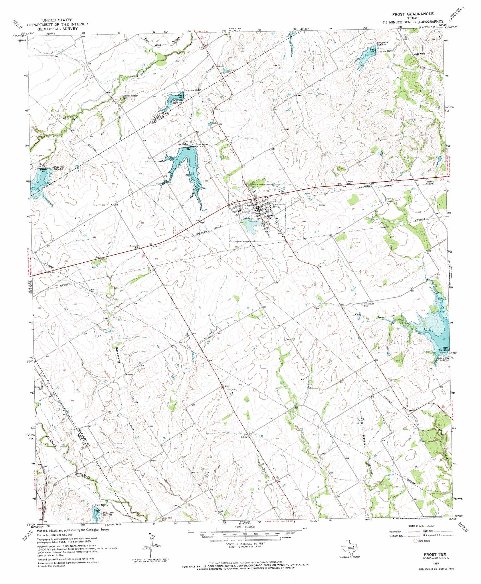
Frost Topo Map Texas
To zoom in, hover over the map of Frost
USGS Topo Quad 32096a7 - 1:24,000 scale
| Topo Map Name: | Frost |
| USGS Topo Quad ID: | 32096a7 |
| Print Size: | ca. 21 1/4" wide x 27" high |
| Southeast Coordinates: | 32° N latitude / 96.75° W longitude |
| Map Center Coordinates: | 32.0625° N latitude / 96.8125° W longitude |
| U.S. State: | TX |
| Filename: | o32096a7.jpg |
| Download Map JPG Image: | Frost topo map 1:24,000 scale |
| Map Type: | Topographic |
| Topo Series: | 7.5´ |
| Map Scale: | 1:24,000 |
| Source of Map Images: | United States Geological Survey (USGS) |
| Alternate Map Versions: |
Frost TX 1965, updated 1967 Download PDF Buy paper map Frost TX 2010 Download PDF Buy paper map Frost TX 2012 Download PDF Buy paper map Frost TX 2016 Download PDF Buy paper map |
1:24,000 Topo Quads surrounding Frost
Maypearl |
Boz |
Forreston |
Ennis West |
Ennis East |
Files Valley |
Italy |
Avalon |
Cryer Creek |
Emhouse |
Hillsboro East |
Mertens |
Frost |
Blooming Grove |
Corbet |
Abbott |
Malone |
Irene |
Dawson |
Purdon |
West |
Penelope |
Hubbard |
Coolidge |
Union High |
> Back to 32096a1 at 1:100,000 scale
> Back to 32096a1 at 1:250,000 scale
> Back to U.S. Topo Maps home
Frost topo map: Gazetteer
Frost: Dams
Dam Number 101A elevation 152m 498′Dam Number 101O elevation 147m 482′
Dam Number 103B elevation 145m 475′
Dam Number 119A elevation 156m 511′
Dam Number 49 elevation 148m 485′
Dam Number 99 elevation 156m 511′
Soil Conservation Service Site 100a Dam elevation 143m 469′
Soil Conservation Service Site 101 Dam elevation 145m 475′
Soil Conservation Service Site 101a Dam elevation 152m 498′
Soil Conservation Service Site 101c Dam elevation 150m 492′
Soil Conservation Service Site 103b Dam elevation 145m 475′
Soil Conservation Service Site 119a Dam elevation 154m 505′
Soil Conservation Service Site 49 Dam elevation 147m 482′
Soil Conservation Service Site 98a Dam elevation 142m 465′
Soil Conservation Service Site 99 Dam elevation 153m 501′
Soil Conservation Service Site 99 Dam elevation 152m 498′
Frost: Parks
Joe Parnum Field elevation 159m 521′Frost: Populated Places
Frost elevation 160m 524′Lone Oak elevation 150m 492′
Frost: Reservoirs
Soil Conservation Service Site 100a Reservoir elevation 143m 469′Soil Conservation Service Site 101 Reservoir elevation 145m 475′
Soil Conservation Service Site 101a Reservoir elevation 152m 498′
Soil Conservation Service Site 101c Reservoir elevation 150m 492′
Soil Conservation Service Site 103b Reservoir elevation 145m 475′
Soil Conservation Service Site 119a Reservoir elevation 154m 505′
Soil Conservation Service Site 49 Reservoir elevation 147m 482′
Soil Conservation Service Site 98a Reservoir elevation 142m 465′
Soil Conservation Service Site 99 Reservoir elevation 152m 498′
Soil Conservation Service Site 99 Reservoir elevation 153m 501′
Frost digital topo map on disk
Buy this Frost topo map showing relief, roads, GPS coordinates and other geographical features, as a high-resolution digital map file on DVD: