Tool Topo Map Texas
To zoom in, hover over the map of Tool
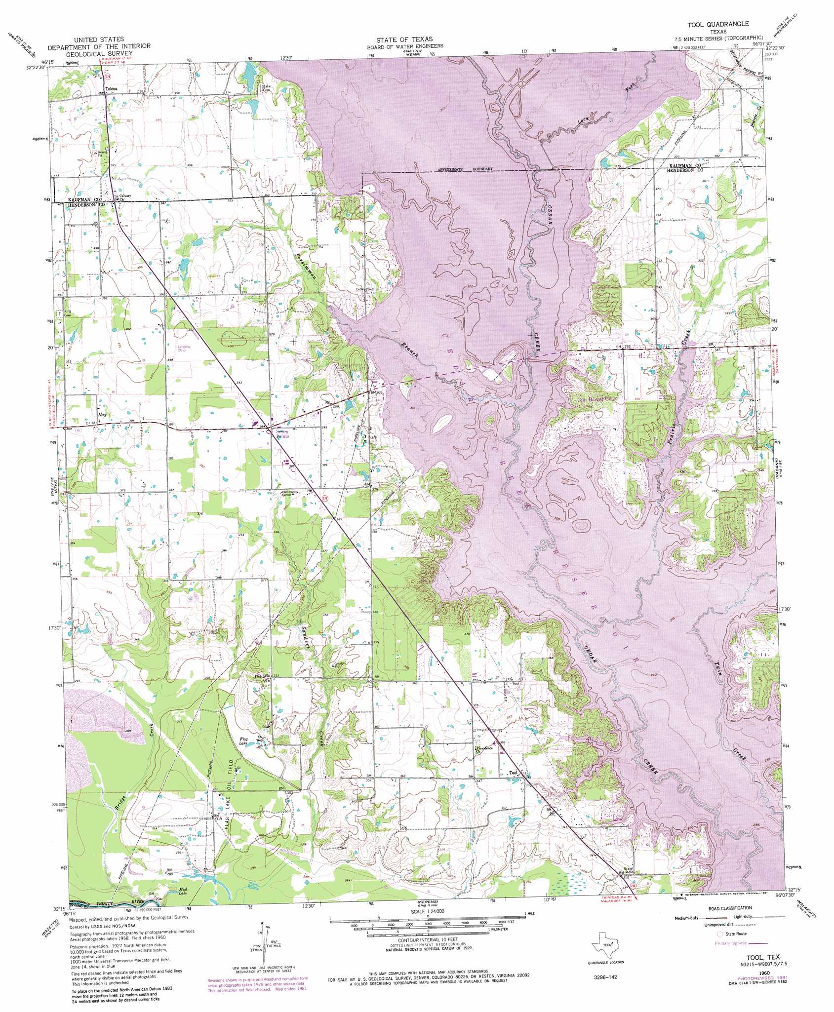
USGS Topo Quad 32096c2 - 1:24,000 scale
| Topo Map Name: | Tool |
| USGS Topo Quad ID: | 32096c2 |
| Print Size: | ca. 21 1/4" wide x 27" high |
| Southeast Coordinates: | 32.25° N latitude / 96.125° W longitude |
| Map Center Coordinates: | 32.3125° N latitude / 96.1875° W longitude |
| U.S. State: | TX |
| Filename: | o32096c2.jpg |
| Download Map JPG Image: | Tool topo map 1:24,000 scale |
| Map Type: | Topographic |
| Topo Series: | 7.5´ |
| Map Scale: | 1:24,000 |
| Source of Map Images: | United States Geological Survey (USGS) |
| Alternate Map Versions: |
Tool TX 1960, updated 1961 Download PDF Buy paper map Tool TX 1960, updated 1973 Download PDF Buy paper map Tool TX 1960, updated 1981 Download PDF Buy paper map Tool TX 2011 Download PDF Buy paper map Tool TX 2012 Download PDF Buy paper map Tool TX 2016 Download PDF Buy paper map |
1:24,000 Topo Quads surrounding Tool
Scurry |
Kaufman |
Ola |
Cedarvale |
Myrtle Springs |
Rosser |
Grays Prairie |
Kemp |
Prairieville |
Phalba |
Rosser Sw |
Styx |
Tool |
Mabank |
Stockard |
Chatfield |
Bazette |
Kerens |
Malakoff |
Mallard Hill |
Corsicana |
Powell |
Goodlow Park |
Creslenn Ranch |
Cross Roads |
> Back to 32096a1 at 1:100,000 scale
> Back to 32096a1 at 1:250,000 scale
> Back to U.S. Topo Maps home
Tool topo map: Gazetteer
Tool: Airports
Harbor Point Airport elevation 114m 374′Tool: Lakes
Flag Lake elevation 91m 298′Mud Lake elevation 87m 285′
Tool: Oilfields
Flag Lake Oil Field elevation 92m 301′Tool: Parks
Cedar Creek Wildlife Management Area - Bird Island Unt elevation 101m 331′Cedar Creek Wildlife Management Area - Telfair Island Unit elevation 101m 331′
Tool: Populated Places
Gun Barrel City elevation 107m 351′Seven Points elevation 117m 383′
Tolosa elevation 112m 367′
Tool elevation 104m 341′
Tool: Streams
Bridge Creek elevation 80m 262′Lacy Fork elevation 98m 321′
Persimmon Branch elevation 98m 321′
Prairie Creek elevation 98m 321′
Tool digital topo map on disk
Buy this Tool topo map showing relief, roads, GPS coordinates and other geographical features, as a high-resolution digital map file on DVD: