Forreston Topo Map Texas
To zoom in, hover over the map of Forreston
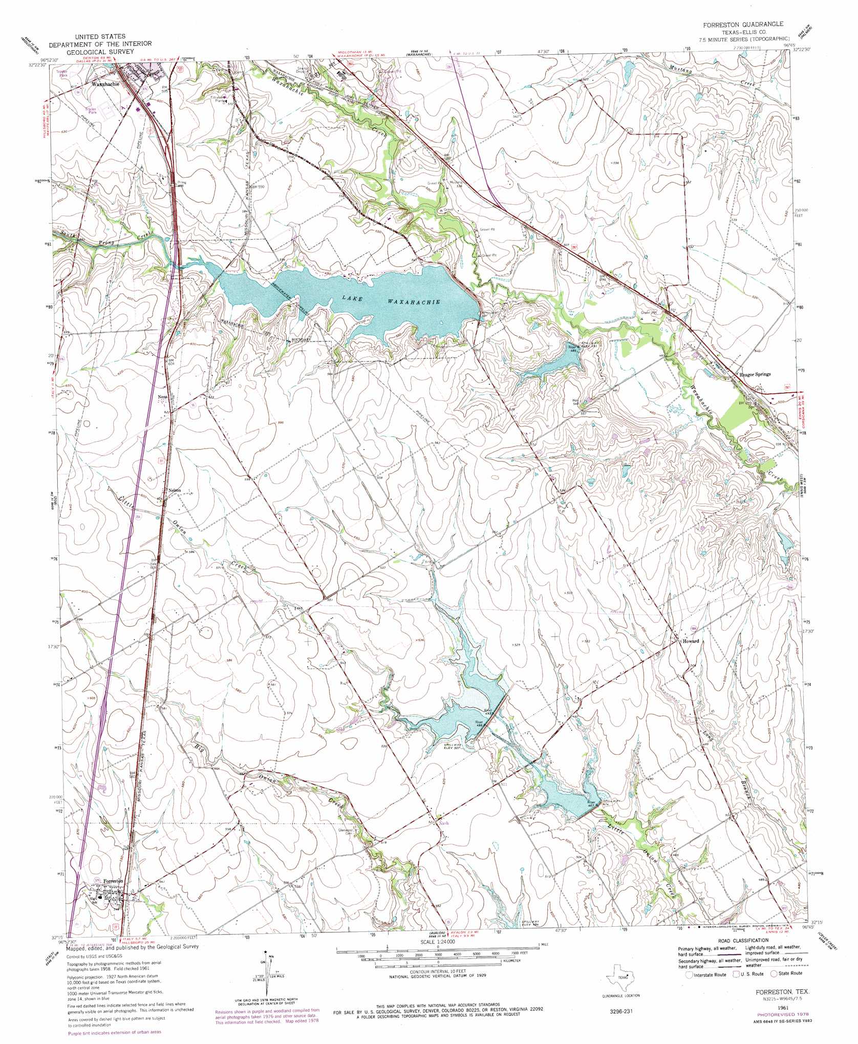
USGS Topo Quad 32096c7 - 1:24,000 scale
| Topo Map Name: | Forreston |
| USGS Topo Quad ID: | 32096c7 |
| Print Size: | ca. 21 1/4" wide x 27" high |
| Southeast Coordinates: | 32.25° N latitude / 96.75° W longitude |
| Map Center Coordinates: | 32.3125° N latitude / 96.8125° W longitude |
| U.S. State: | TX |
| Filename: | o32096c7.jpg |
| Download Map JPG Image: | Forreston topo map 1:24,000 scale |
| Map Type: | Topographic |
| Topo Series: | 7.5´ |
| Map Scale: | 1:24,000 |
| Source of Map Images: | United States Geological Survey (USGS) |
| Alternate Map Versions: |
Forreston TX 1961, updated 1963 Download PDF Buy paper map Forreston TX 1961, updated 1979 Download PDF Buy paper map Forreston TX 2010 Download PDF Buy paper map Forreston TX 2012 Download PDF Buy paper map Forreston TX 2016 Download PDF Buy paper map |
1:24,000 Topo Quads surrounding Forreston
Britton |
Cedar Hill |
Lancaster |
Ferris |
India |
Venus |
Midlothian |
Waxahachie |
Palmer |
Bristol |
Maypearl |
Boz |
Forreston |
Ennis West |
Ennis East |
Files Valley |
Italy |
Avalon |
Cryer Creek |
Emhouse |
Hillsboro East |
Mertens |
Frost |
Blooming Grove |
Corbet |
> Back to 32096a1 at 1:100,000 scale
> Back to 32096a1 at 1:250,000 scale
> Back to U.S. Topo Maps home
Forreston topo map: Gazetteer
Forreston: Airports
George P Shanks Airport elevation 183m 600′Forreston: Dams
Soil Conservation Service Site 111 and 112 Dam elevation 154m 505′Soil Conservation Service Site 113 Dam elevation 139m 456′
Soil Conservation Service Site 23 Dam elevation 147m 482′
Soil Conservation Service Site 24 Dam elevation 143m 469′
South Prong Dam elevation 149m 488′
Forreston: Parks
Spring Park elevation 166m 544′Forreston: Populated Places
Forreston elevation 165m 541′Howard elevation 156m 511′
Nash elevation 159m 521′
Nelson elevation 186m 610′
Nena elevation 190m 623′
Reagor Springs elevation 149m 488′
Forreston: Reservoirs
Lake Waxahachie elevation 164m 538′Soil Conservation Service Site 111 and 112 Reservoir elevation 154m 505′
Soil Conservation Service Site 113 Reservoir elevation 139m 456′
Soil Conservation Service Site 23 Reservoir elevation 147m 482′
Soil Conservation Service Site 24 Reservoir elevation 143m 469′
Forreston: Streams
South Prong Creek elevation 146m 479′Forreston digital topo map on disk
Buy this Forreston topo map showing relief, roads, GPS coordinates and other geographical features, as a high-resolution digital map file on DVD: