Prairieville Topo Map Texas
To zoom in, hover over the map of Prairieville
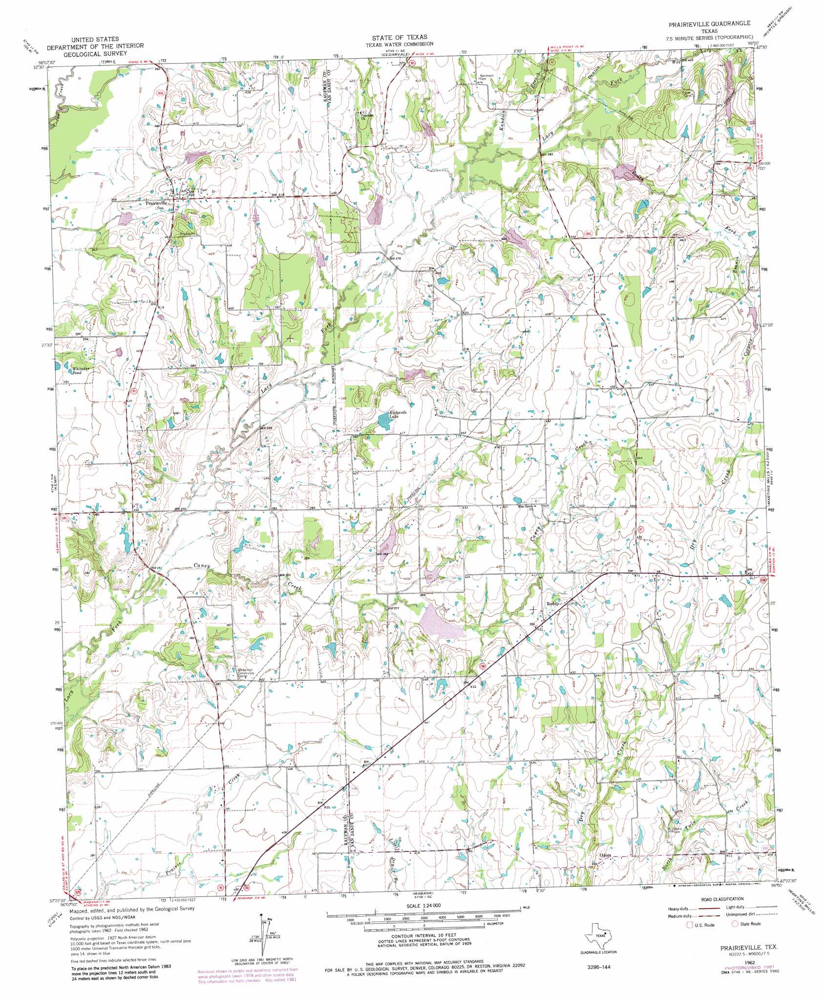
USGS Topo Quad 32096d1 - 1:24,000 scale
| Topo Map Name: | Prairieville |
| USGS Topo Quad ID: | 32096d1 |
| Print Size: | ca. 21 1/4" wide x 27" high |
| Southeast Coordinates: | 32.375° N latitude / 96° W longitude |
| Map Center Coordinates: | 32.4375° N latitude / 96.0625° W longitude |
| U.S. State: | TX |
| Filename: | o32096d1.jpg |
| Download Map JPG Image: | Prairieville topo map 1:24,000 scale |
| Map Type: | Topographic |
| Topo Series: | 7.5´ |
| Map Scale: | 1:24,000 |
| Source of Map Images: | United States Geological Survey (USGS) |
| Alternate Map Versions: |
Prairieville TX 1962, updated 1965 Download PDF Buy paper map Prairieville TX 1962, updated 1982 Download PDF Buy paper map Prairieville TX 2010 Download PDF Buy paper map Prairieville TX 2012 Download PDF Buy paper map Prairieville TX 2016 Download PDF Buy paper map |
1:24,000 Topo Quads surrounding Prairieville
Terrell South |
Elmo |
Wills Point |
Edgewood |
Fruitvale |
Kaufman |
Ola |
Cedarvale |
Myrtle Springs |
Canton |
Grays Prairie |
Kemp |
Prairieville |
Phalba |
Martins Mill |
Styx |
Tool |
Mabank |
Stockard |
Murchinson West |
Bazette |
Kerens |
Malakoff |
Mallard Hill |
Athens |
> Back to 32096a1 at 1:100,000 scale
> Back to 32096a1 at 1:250,000 scale
> Back to U.S. Topo Maps home
Prairieville topo map: Gazetteer
Prairieville: Airports
Manning Airport elevation 116m 380′Prairieville: Dams
Richards Lake Dam elevation 122m 400′Soil Conservation Service Site 120 Dam elevation 113m 370′
Soil Conservation Service Site 121a Dam elevation 108m 354′
Soil Conservation Service Site 130a Dam elevation 120m 393′
Soil Conservation Service Site 130b Dam elevation 115m 377′
Soil Conservation Service Site 131 Dam elevation 116m 380′
Soil Conservation Service Site 135a Dam elevation 133m 436′
Soil Conservation Service Site 135c Dam elevation 119m 390′
Soil Conservation Service Site 136 Dam elevation 122m 400′
Soil Conservation Service Site 137 Dam elevation 116m 380′
Soil Conservation Service Site 138 Dam elevation 116m 380′
Soil Conservation Service Site 139 Dam elevation 117m 383′
Soil Conservation Service Site 140 Dam elevation 117m 383′
Prairieville: Lakes
Whitaker Pond elevation 119m 390′Prairieville: Populated Places
Odom elevation 125m 410′Prairieville elevation 121m 396′
Roddy elevation 134m 439′
Prairieville: Reservoirs
Richards Lake elevation 123m 403′Soil Conservation Service Site 120 Reservoir elevation 113m 370′
Soil Conservation Service Site 121a Reservoir elevation 108m 354′
Soil Conservation Service Site 130a Reservoir elevation 120m 393′
Soil Conservation Service Site 130b Reservoir elevation 115m 377′
Soil Conservation Service Site 131 Reservoir elevation 116m 380′
Soil Conservation Service Site 135a Reservoir elevation 133m 436′
Soil Conservation Service Site 135c Reservoir elevation 119m 390′
Soil Conservation Service Site 136 Reservoir elevation 122m 400′
Soil Conservation Service Site 137 Reservoir elevation 116m 380′
Soil Conservation Service Site 138 Reservoir elevation 116m 380′
Soil Conservation Service Site 139 Reservoir elevation 117m 383′
Soil Conservation Service Site 140 Reservoir elevation 117m 383′
Prairieville: Streams
Caney Creek elevation 99m 324′Coppers Branch elevation 127m 416′
Denton Creek elevation 121m 396′
Dry Lacy Fork elevation 122m 400′
Knudson Branch elevation 116m 380′
South Fork Lacy Fork elevation 117m 383′
Wet Lacy Fork elevation 122m 400′
Prairieville digital topo map on disk
Buy this Prairieville topo map showing relief, roads, GPS coordinates and other geographical features, as a high-resolution digital map file on DVD: