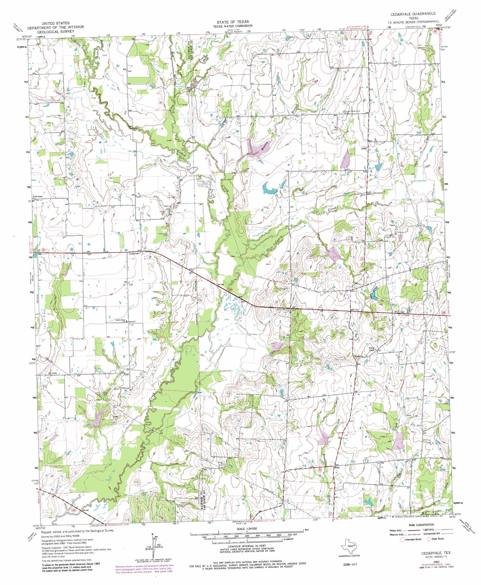
Cedarvale Topo Map Texas
To zoom in, hover over the map of Cedarvale
USGS Topo Quad 32096e1 - 1:24,000 scale
| Topo Map Name: | Cedarvale |
| USGS Topo Quad ID: | 32096e1 |
| Print Size: | ca. 21 1/4" wide x 27" high |
| Southeast Coordinates: | 32.5° N latitude / 96° W longitude |
| Map Center Coordinates: | 32.5625° N latitude / 96.0625° W longitude |
| U.S. State: | TX |
| Filename: | o32096e1.jpg |
| Download Map JPG Image: | Cedarvale topo map 1:24,000 scale |
| Map Type: | Topographic |
| Topo Series: | 7.5´ |
| Map Scale: | 1:24,000 |
| Source of Map Images: | United States Geological Survey (USGS) |
| Alternate Map Versions: |
Cedarvale TX 1962, updated 1965 Download PDF Buy paper map Cedarvale TX 1962, updated 1982 Download PDF Buy paper map Cedarvale TX 2010 Download PDF Buy paper map Cedarvale TX 2012 Download PDF Buy paper map Cedarvale TX 2016 Download PDF Buy paper map |
1:24,000 Topo Quads surrounding Cedarvale
Terrell North |
Poetry |
Ables Springs |
Iron Bridge Dam |
Emory South |
Terrell South |
Elmo |
Wills Point |
Edgewood |
Fruitvale |
Kaufman |
Ola |
Cedarvale |
Myrtle Springs |
Canton |
Grays Prairie |
Kemp |
Prairieville |
Phalba |
Martins Mill |
Styx |
Tool |
Mabank |
Stockard |
Murchinson West |
> Back to 32096e1 at 1:100,000 scale
> Back to 32096a1 at 1:250,000 scale
> Back to U.S. Topo Maps home
Cedarvale topo map: Gazetteer
Cedarvale: Airports
Goode Field elevation 134m 439′Cedarvale: Dams
Bobbitt Lake Dam elevation 123m 403′Soil Conservation Service Site 109 Dam elevation 128m 419′
Soil Conservation Service Site 110 Dam elevation 122m 400′
Soil Conservation Service Site 113 Dam elevation 123m 403′
Soil Conservation Service Site 114 Dam elevation 119m 390′
Soil Conservation Service Site 117 Dam elevation 113m 370′
Soil Conservation Service Site 128 Dam elevation 130m 426′
Soil Conservation Service Site 129 Dam elevation 131m 429′
Cedarvale: Populated Places
Cana elevation 135m 442′Cedarvale elevation 125m 410′
Scott elevation 136m 446′
Watkins elevation 146m 479′
Wise elevation 131m 429′
Cedarvale: Reservoirs
Bobbitt Lake elevation 123m 403′Soil Conservation Service Site 109 Reservoir elevation 128m 419′
Soil Conservation Service Site 110 Reservoir elevation 122m 400′
Soil Conservation Service Site 113 Reservoir elevation 123m 403′
Soil Conservation Service Site 114 Reservoir elevation 119m 390′
Soil Conservation Service Site 117 Reservoir elevation 113m 370′
Soil Conservation Service Site 128 Reservoir elevation 130m 426′
Soil Conservation Service Site 129 Reservoir elevation 131m 429′
Cedarvale: Streams
Allen Creek elevation 119m 390′Caney Creek elevation 111m 364′
Flat Creek elevation 123m 403′
Massey Branch elevation 116m 380′
Muddy Cedar Creek elevation 125m 410′
Rocky Cedar Creek elevation 125m 410′
Wolf Creek elevation 122m 400′
Cedarvale digital topo map on disk
Buy this Cedarvale topo map showing relief, roads, GPS coordinates and other geographical features, as a high-resolution digital map file on DVD: