India Topo Map Texas
To zoom in, hover over the map of India
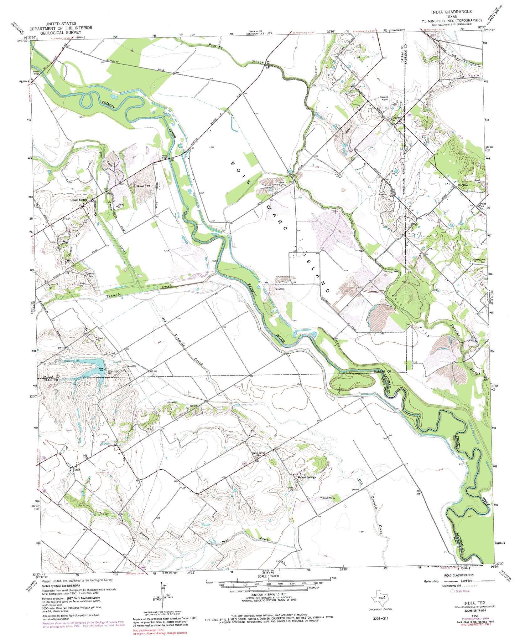
USGS Topo Quad 32096e5 - 1:24,000 scale
| Topo Map Name: | India |
| USGS Topo Quad ID: | 32096e5 |
| Print Size: | ca. 21 1/4" wide x 27" high |
| Southeast Coordinates: | 32.5° N latitude / 96.5° W longitude |
| Map Center Coordinates: | 32.5625° N latitude / 96.5625° W longitude |
| U.S. State: | TX |
| Filename: | o32096e5.jpg |
| Download Map JPG Image: | India topo map 1:24,000 scale |
| Map Type: | Topographic |
| Topo Series: | 7.5´ |
| Map Scale: | 1:24,000 |
| Source of Map Images: | United States Geological Survey (USGS) |
| Alternate Map Versions: |
India TX 1959, updated 1960 Download PDF Buy paper map India TX 1959, updated 1969 Download PDF Buy paper map India TX 1959, updated 1980 Download PDF Buy paper map India TX 1959, updated 1988 Download PDF Buy paper map India TX 2010 Download PDF Buy paper map India TX 2012 Download PDF Buy paper map India TX 2016 Download PDF Buy paper map |
1:24,000 Topo Quads surrounding India
Dallas |
White Rock Lake |
Mesquite |
Forney North |
Terrell North |
Oak Cliff |
Hutchins |
Seagoville |
Forney South |
Terrell South |
Lancaster |
Ferris |
India |
Scurry |
Kaufman |
Waxahachie |
Palmer |
Bristol |
Rosser |
Grays Prairie |
Forreston |
Ennis West |
Ennis East |
Rosser Sw |
Styx |
> Back to 32096e1 at 1:100,000 scale
> Back to 32096a1 at 1:250,000 scale
> Back to U.S. Topo Maps home
India topo map: Gazetteer
India: Airports
Seagoville Airport elevation 126m 413′India: Bridges
Malloy Bridge elevation 110m 360′Wilmer Bridge elevation 109m 357′
India: Dams
Soil Conservation Service Site 10 Dam elevation 118m 387′Soil Conservation Service Site 3 Dam elevation 116m 380′
Soil Conservation Service Site 4 Dam elevation 118m 387′
Soil Conservation Service Site 9 Dam elevation 115m 377′
India: Islands
Bois D'Arc Island elevation 109m 357′India: Populated Places
Combine elevation 126m 413′India elevation 135m 442′
Walnut Springs elevation 119m 390′
India: Reservoirs
Soil Conservation Service Site 10 Reservoir elevation 118m 387′Soil Conservation Service Site 3 Reservoir elevation 116m 380′
Soil Conservation Service Site 4 Reservoir elevation 118m 387′
Soil Conservation Service Site 9 Reservoir elevation 115m 377′
India: Streams
Cottonwood Creek elevation 108m 354′Gravel Slough elevation 108m 354′
India Branch elevation 110m 360′
Parsons Slough elevation 104m 341′
Tenmile Creek elevation 107m 351′
India digital topo map on disk
Buy this India topo map showing relief, roads, GPS coordinates and other geographical features, as a high-resolution digital map file on DVD: