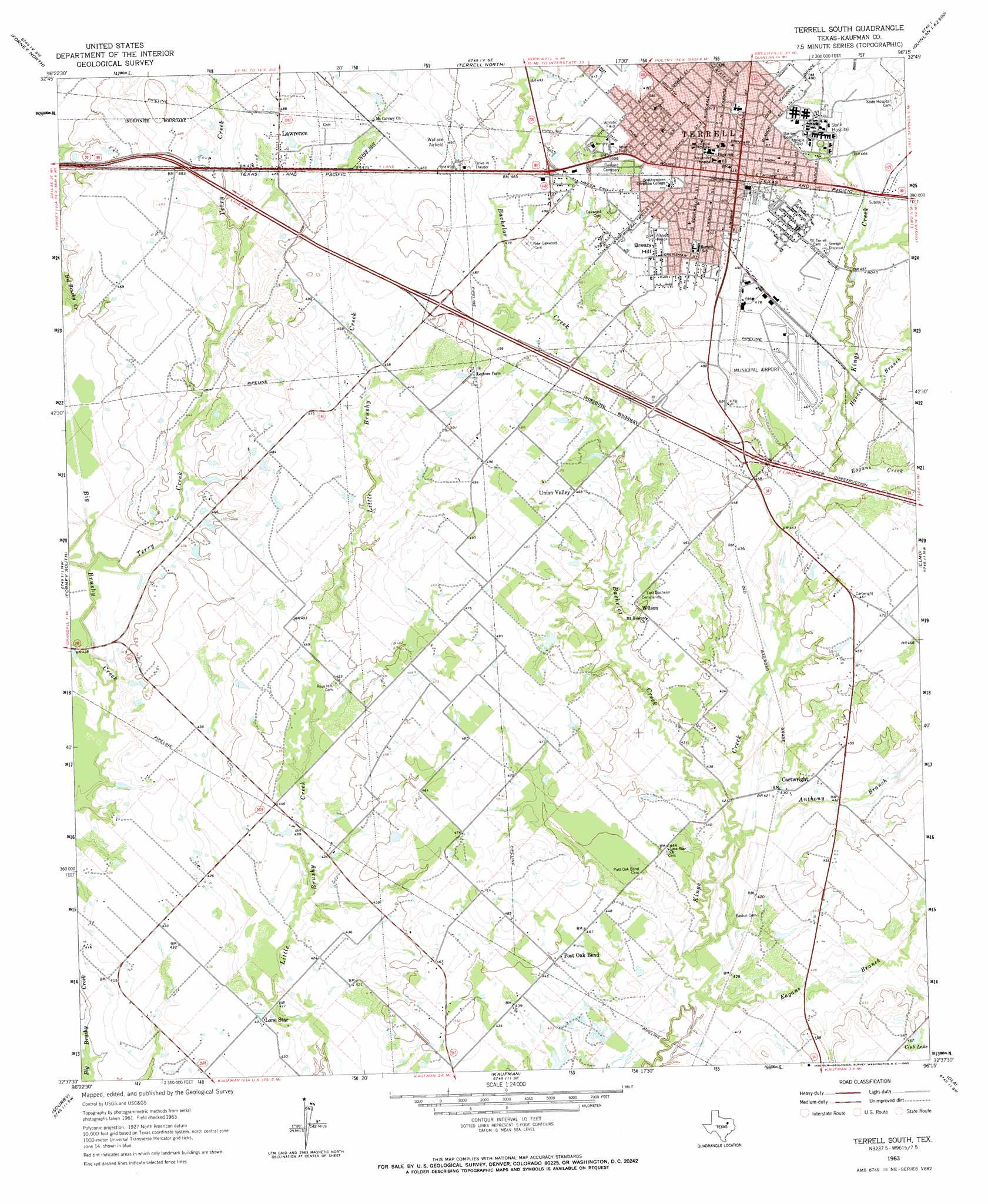
Terrell South Topo Map Texas
To zoom in, hover over the map of Terrell South
USGS Topo Quad 32096f3 - 1:24,000 scale
| Topo Map Name: | Terrell South |
| USGS Topo Quad ID: | 32096f3 |
| Print Size: | ca. 21 1/4" wide x 27" high |
| Southeast Coordinates: | 32.625° N latitude / 96.25° W longitude |
| Map Center Coordinates: | 32.6875° N latitude / 96.3125° W longitude |
| U.S. State: | TX |
| Filename: | o32096f3.jpg |
| Download Map JPG Image: | Terrell South topo map 1:24,000 scale |
| Map Type: | Topographic |
| Topo Series: | 7.5´ |
| Map Scale: | 1:24,000 |
| Source of Map Images: | United States Geological Survey (USGS) |
| Alternate Map Versions: |
Terrell South TX 1963, updated 1965 Download PDF Buy paper map Terrell South TX 2010 Download PDF Buy paper map Terrell South TX 2012 Download PDF Buy paper map Terrell South TX 2016 Download PDF Buy paper map |
1:24,000 Topo Quads surrounding Terrell South
Rowlett |
Rockwall |
Royse City |
Quinlan |
West Tawakoni |
Mesquite |
Forney North |
Terrell North |
Poetry |
Ables Springs |
Seagoville |
Forney South |
Terrell South |
Elmo |
Wills Point |
India |
Scurry |
Kaufman |
Ola |
Cedarvale |
Bristol |
Rosser |
Grays Prairie |
Kemp |
Prairieville |
> Back to 32096e1 at 1:100,000 scale
> Back to 32096a1 at 1:250,000 scale
> Back to U.S. Topo Maps home
Terrell South topo map: Gazetteer
Terrell South: Airports
Flying G Airport elevation 140m 459′Terrell Community Hospital Heliport elevation 146m 479′
Terrell Municipal Airport elevation 143m 469′
Terrell South: Dams
North Haven Construction Company Lake Dam elevation 139m 456′Terrell South: Parks
Breezy Hill Park elevation 163m 534′Gill Park elevation 157m 515′
Terrell Memorial Stadium elevation 155m 508′
Terrell South: Populated Places
Cartwright elevation 131m 429′Lawrence elevation 147m 482′
Lone Star elevation 132m 433′
Oak Ridge elevation 128m 419′
Post Oak Bend elevation 136m 446′
Post Oak Bend City elevation 134m 439′
Terrell elevation 155m 508′
Union Valley elevation 143m 469′
Wilson elevation 138m 452′
Terrell South: Reservoirs
Club Lake elevation 140m 459′North Haven Construction Company Lake elevation 139m 456′
Terrell South: Streams
Anthony Branch elevation 126m 413′Bachelor Creek elevation 127m 416′
Eagans Branch elevation 124m 406′
Eagans Creek elevation 134m 439′
Hardin Branch elevation 134m 439′
Terry Creek elevation 128m 419′
Walnut Creek elevation 137m 449′
Terrell South: Summits
Breezy Hill elevation 165m 541′Terrell South digital topo map on disk
Buy this Terrell South topo map showing relief, roads, GPS coordinates and other geographical features, as a high-resolution digital map file on DVD: