Forney South Topo Map Texas
To zoom in, hover over the map of Forney South
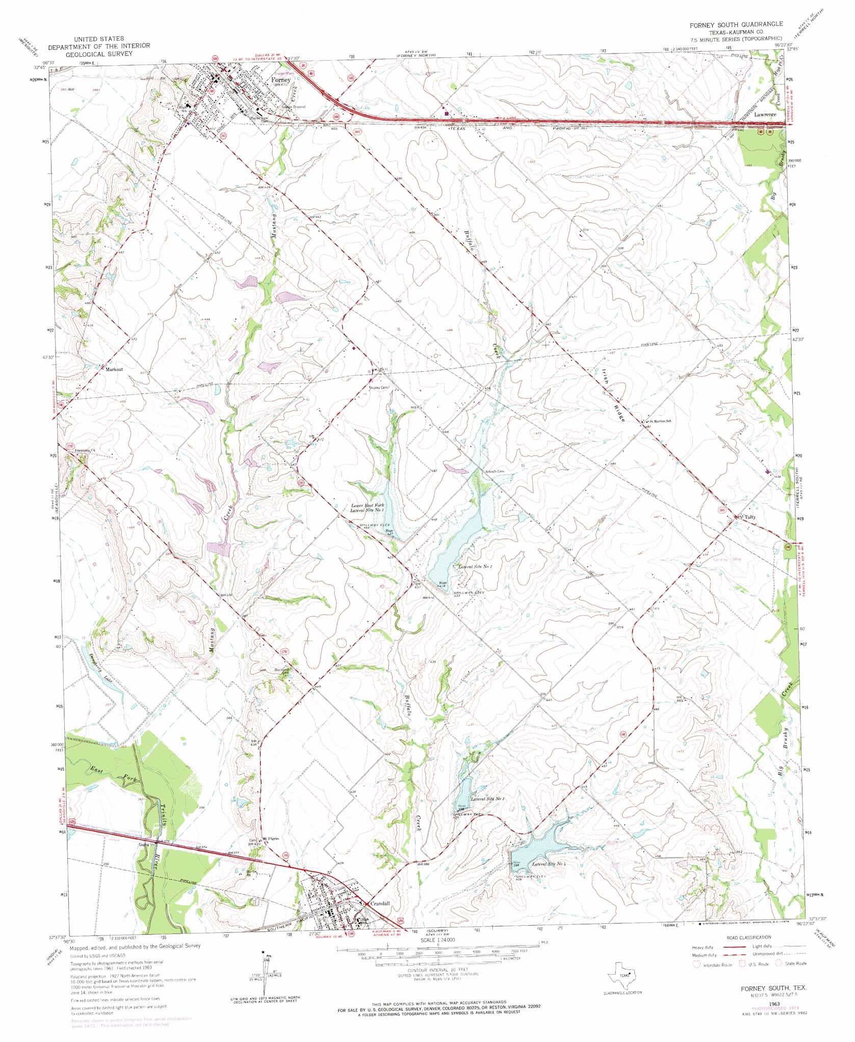
USGS Topo Quad 32096f4 - 1:24,000 scale
| Topo Map Name: | Forney South |
| USGS Topo Quad ID: | 32096f4 |
| Print Size: | ca. 21 1/4" wide x 27" high |
| Southeast Coordinates: | 32.625° N latitude / 96.375° W longitude |
| Map Center Coordinates: | 32.6875° N latitude / 96.4375° W longitude |
| U.S. State: | TX |
| Filename: | o32096f4.jpg |
| Download Map JPG Image: | Forney South topo map 1:24,000 scale |
| Map Type: | Topographic |
| Topo Series: | 7.5´ |
| Map Scale: | 1:24,000 |
| Source of Map Images: | United States Geological Survey (USGS) |
| Alternate Map Versions: |
Forney South TX 1963 Download PDF Buy paper map Forney South TX 1963, updated 1966 Download PDF Buy paper map Forney South TX 1963, updated 1974 Download PDF Buy paper map Forney South TX 2010 Download PDF Buy paper map Forney South TX 2012 Download PDF Buy paper map Forney South TX 2016 Download PDF Buy paper map |
1:24,000 Topo Quads surrounding Forney South
Garland |
Rowlett |
Rockwall |
Royse City |
Quinlan |
White Rock Lake |
Mesquite |
Forney North |
Terrell North |
Poetry |
Hutchins |
Seagoville |
Forney South |
Terrell South |
Elmo |
Ferris |
India |
Scurry |
Kaufman |
Ola |
Palmer |
Bristol |
Rosser |
Grays Prairie |
Kemp |
> Back to 32096e1 at 1:100,000 scale
> Back to 32096a1 at 1:250,000 scale
> Back to U.S. Topo Maps home
Forney South topo map: Gazetteer
Forney South: Airports
Parker Field elevation 136m 446′Smith Field elevation 154m 505′
Sunset Airport elevation 135m 442′
Forney South: Dams
Murphy Lake Dam elevation 135m 442′Soil Conservation Service Site 1 Dam elevation 125m 410′
Soil Conservation Service Site 11 Dam elevation 117m 383′
Soil Conservation Service Site 11a Dam elevation 123m 403′
Soil Conservation Service Site 11b Dam elevation 130m 426′
Soil Conservation Service Site 11d Dam elevation 131m 429′
Soil Conservation Service Site 11f Dam elevation 131m 429′
Soil Conservation Service Site 11g Dam elevation 128m 419′
Soil Conservation Service Site 11h Dam elevation 121m 396′
Soil Conservation Service Site 11k Dam elevation 124m 406′
Soil Conservation Service Site 2 Dam elevation 122m 400′
Soil Conservation Service Site 3 Dam elevation 121m 396′
Soil Conservation Service Site 31 Dam elevation 128m 419′
Soil Conservation Service Site 32 Dam elevation 130m 426′
Soil Conservation Service Site 33 Dam elevation 124m 406′
Forney South: Lakes
Daugherty Lake elevation 108m 354′Forney South: Parks
Jackrabbit Stadium elevation 145m 475′Forney South: Populated Places
Crandall elevation 129m 423′Forney elevation 144m 472′
Markout elevation 142m 465′
Talty elevation 134m 439′
Forney South: Post Offices
Forney Post Office elevation 144m 472′Forney South: Reservoirs
Lateral Site Number Four elevation 124m 406′Lateral Site Number Three elevation 125m 410′
Lateral Site Number Two elevation 132m 433′
Lower East Fork Lateral Site Number One elevation 134m 439′
Soil Conservation Service Site 1 Reservoir elevation 135m 442′
Soil Conservation Service Site 11 Reservoir elevation 117m 383′
Soil Conservation Service Site 11a Reservoir elevation 123m 403′
Soil Conservation Service Site 11b Reservoir elevation 130m 426′
Soil Conservation Service Site 11d Reservoir elevation 131m 429′
Soil Conservation Service Site 11f Reservoir elevation 131m 429′
Soil Conservation Service Site 11g Reservoir elevation 128m 419′
Soil Conservation Service Site 11h Reservoir elevation 121m 396′
Soil Conservation Service Site 11k Reservoir elevation 124m 406′
Soil Conservation Service Site 2 Reservoir elevation 125m 410′
Soil Conservation Service Site 3 Reservoir elevation 122m 400′
Soil Conservation Service Site 31 Reservoir elevation 128m 419′
Soil Conservation Service Site 32 Reservoir elevation 130m 426′
Soil Conservation Service Site 33 Reservoir elevation 124m 406′
Soil Conservation Service Site 4 Reservoir elevation 121m 396′
Forney South: Ridges
Irish Ridge elevation 153m 501′Forney South: Streams
High Point Creek elevation 134m 439′Mustang Creek elevation 107m 351′
Forney South digital topo map on disk
Buy this Forney South topo map showing relief, roads, GPS coordinates and other geographical features, as a high-resolution digital map file on DVD: