Hutchins Topo Map Texas
To zoom in, hover over the map of Hutchins
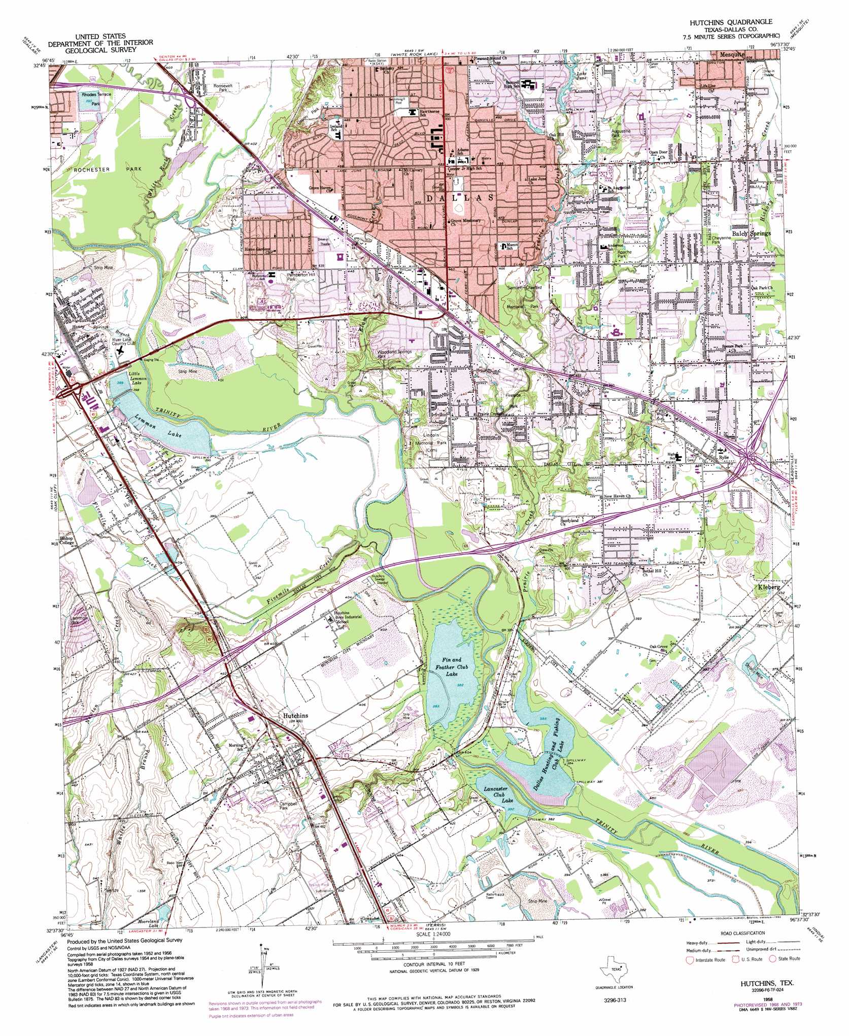
USGS Topo Quad 32096f6 - 1:24,000 scale
| Topo Map Name: | Hutchins |
| USGS Topo Quad ID: | 32096f6 |
| Print Size: | ca. 21 1/4" wide x 27" high |
| Southeast Coordinates: | 32.625° N latitude / 96.625° W longitude |
| Map Center Coordinates: | 32.6875° N latitude / 96.6875° W longitude |
| U.S. State: | TX |
| Filename: | o32096f6.jpg |
| Download Map JPG Image: | Hutchins topo map 1:24,000 scale |
| Map Type: | Topographic |
| Topo Series: | 7.5´ |
| Map Scale: | 1:24,000 |
| Source of Map Images: | United States Geological Survey (USGS) |
| Alternate Map Versions: |
Hutchins TX 1958, updated 1959 Download PDF Buy paper map Hutchins TX 1958, updated 1969 Download PDF Buy paper map Hutchins TX 1958, updated 1974 Download PDF Buy paper map Hutchins TX 1958, updated 1985 Download PDF Buy paper map Hutchins TX 1958, updated 1992 Download PDF Buy paper map Hutchins TX 1995, updated 2001 Download PDF Buy paper map Hutchins TX 2010 Download PDF Buy paper map Hutchins TX 2012 Download PDF Buy paper map Hutchins TX 2016 Download PDF Buy paper map |
1:24,000 Topo Quads surrounding Hutchins
Carrollton |
Addison |
Garland |
Rowlett |
Rockwall |
Irving |
Dallas |
White Rock Lake |
Mesquite |
Forney North |
Duncanville |
Oak Cliff |
Hutchins |
Seagoville |
Forney South |
Cedar Hill |
Lancaster |
Ferris |
India |
Scurry |
Midlothian |
Waxahachie |
Palmer |
Bristol |
Rosser |
> Back to 32096e1 at 1:100,000 scale
> Back to 32096a1 at 1:250,000 scale
> Back to U.S. Topo Maps home
Hutchins topo map: Gazetteer
Hutchins: Airports
Culp Airport elevation 123m 403′Hutchins: Crossings
Interchange 1C elevation 140m 459′Interchange 473A elevation 153m 501′
Interchange 473B elevation 149m 488′
Interchange 474 elevation 139m 456′
Interchange 476 elevation 122m 400′
Interchange 477 elevation 131m 429′
Interchange 479A and 479B elevation 139m 456′
Interchange 480 elevation 139m 456′
Hutchins: Dams
Dallas Hunt and Fish Club Lower Lake Dam elevation 117m 383′Dallas Hunt and Fish Club Upper Lake Dam elevation 117m 383′
Lake June Dam elevation 143m 469′
Lancaster Club Lake Dam elevation 121m 396′
Lemmon Lake Dam elevation 119m 390′
Hutchins: Lakes
Fin and Feather Club Lake elevation 116m 380′Hutchins: Parks
Apache Park elevation 144m 472′Blazer Stadium elevation 154m 505′
Campbell Park elevation 139m 456′
Cheyenne Park elevation 148m 485′
Crawford Park elevation 129m 423′
Devon Park elevation 135m 442′
Eagle Stadium elevation 158m 518′
Fireside Park elevation 124m 406′
Holcomb Park elevation 145m 475′
Lemmon Park elevation 132m 433′
Pemberton Hill Park elevation 134m 439′
Pleasant Grove Stadium elevation 148m 485′
Rhoads Terrace Park elevation 120m 393′
Rochester Park elevation 121m 396′
Rochester Park elevation 120m 393′
Roosevelt Park elevation 119m 390′
Rylie Park elevation 141m 462′
Rylie Stadium elevation 140m 459′
Saint Augustine Park elevation 149m 488′
Samuel - Elam Park elevation 131m 429′
Umphress Park elevation 147m 482′
Woodland Springs Park elevation 123m 403′
Hutchins: Populated Places
Hutchins elevation 142m 465′Rylie elevation 140m 459′
Hutchins: Post Offices
Pleasant Grove Post Office elevation 138m 452′Hutchins: Reservoirs
Dallas Hunting and Fishing Club Lake elevation 117m 383′Lake June elevation 143m 469′
Lancaster Club Lake elevation 116m 380′
Lemmon Lake elevation 121m 396′
Little Lemmon Lake elevation 121m 396′
Mooreland Lake elevation 165m 541′
Hutchins: Streams
Elam Creek elevation 116m 380′Fivemile Creek elevation 113m 370′
Honey Springs Branch elevation 116m 380′
Newton Creek elevation 120m 393′
Prairie Creek elevation 113m 370′
White Rock Creek elevation 116m 380′
Whites Branch elevation 129m 423′
Hutchins digital topo map on disk
Buy this Hutchins topo map showing relief, roads, GPS coordinates and other geographical features, as a high-resolution digital map file on DVD: