Addison Topo Map Texas
To zoom in, hover over the map of Addison
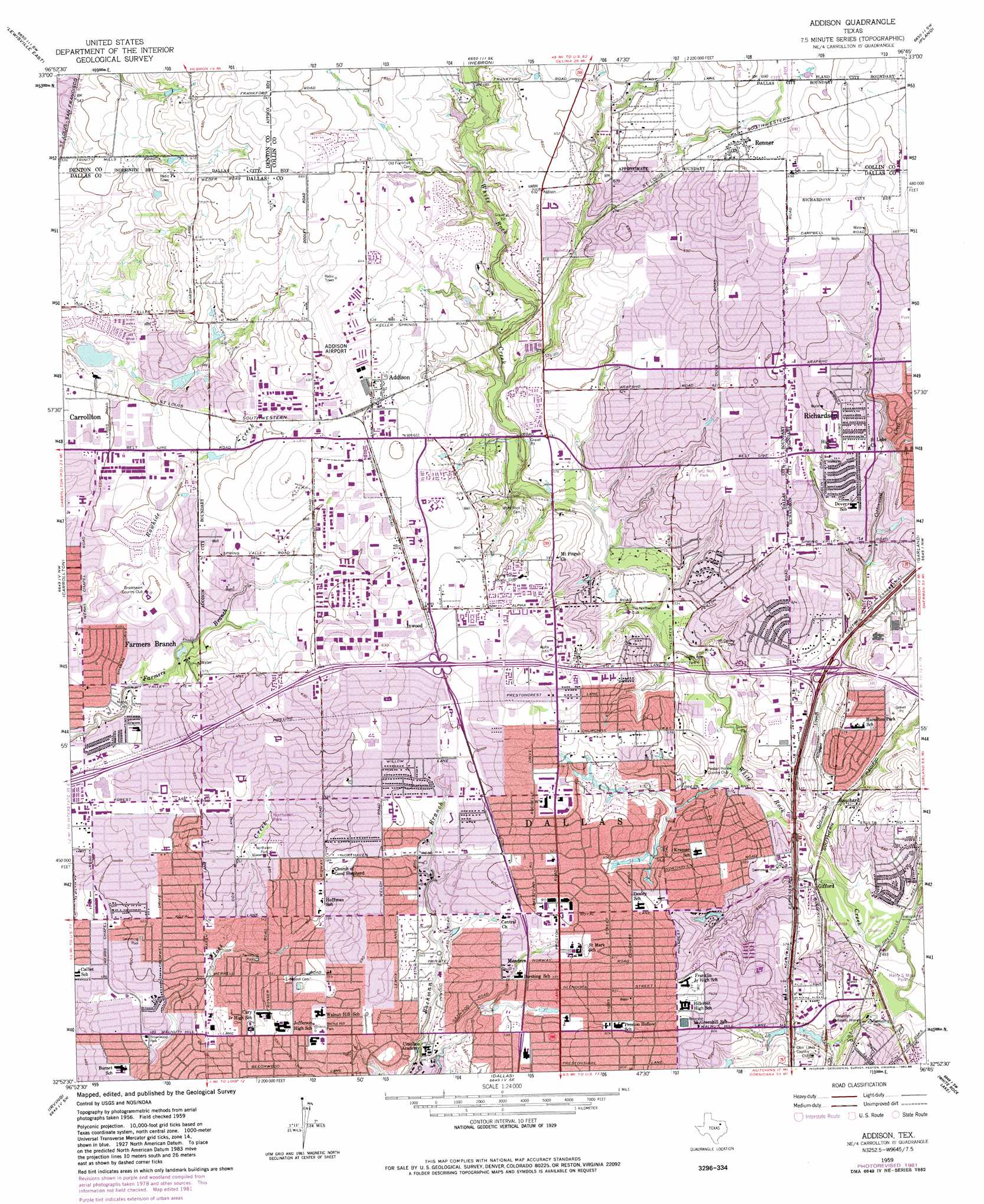
USGS Topo Quad 32096h7 - 1:24,000 scale
| Topo Map Name: | Addison |
| USGS Topo Quad ID: | 32096h7 |
| Print Size: | ca. 21 1/4" wide x 27" high |
| Southeast Coordinates: | 32.875° N latitude / 96.75° W longitude |
| Map Center Coordinates: | 32.9375° N latitude / 96.8125° W longitude |
| U.S. State: | TX |
| Filename: | o32096h7.jpg |
| Download Map JPG Image: | Addison topo map 1:24,000 scale |
| Map Type: | Topographic |
| Topo Series: | 7.5´ |
| Map Scale: | 1:24,000 |
| Source of Map Images: | United States Geological Survey (USGS) |
| Alternate Map Versions: |
Addison TX 1959, updated 1960 Download PDF Buy paper map Addison TX 1959, updated 1960 Download PDF Buy paper map Addison TX 1959, updated 1969 Download PDF Buy paper map Addison TX 1959, updated 1974 Download PDF Buy paper map Addison TX 1959, updated 1982 Download PDF Buy paper map Addison TX 1959, updated 1986 Download PDF Buy paper map Addison TX 2010 Download PDF Buy paper map Addison TX 2012 Download PDF Buy paper map Addison TX 2016 Download PDF Buy paper map |
1:24,000 Topo Quads surrounding Addison
Denton East |
Little Elm |
Frisco |
Mckinney West |
Mckinney East |
Lewisville West |
Lewisville East |
Hebron |
Plano |
Wylie |
Grapevine |
Carrollton |
Addison |
Garland |
Rowlett |
Euless |
Irving |
Dallas |
White Rock Lake |
Mesquite |
Arlington |
Duncanville |
Oak Cliff |
Hutchins |
Seagoville |
> Back to 32096e1 at 1:100,000 scale
> Back to 32096a1 at 1:250,000 scale
> Back to U.S. Topo Maps home
Addison topo map: Gazetteer
Addison: Airports
Addison Airport elevation 197m 646′Medical City Dallas Hospital Heliport elevation 152m 498′
Presbyterian Hospital of Dallas Heliport elevation 157m 515′
T I Company Heliport elevation 167m 547′
Addison: Crossings
Interchange 19A and 19B elevation 172m 564′Interchange 20 elevation 186m 610′
Interchange 21 elevation 195m 639′
Interchange 21A elevation 167m 547′
Interchange 21B elevation 168m 551′
Interchange 22A elevation 192m 629′
Interchange 22B elevation 188m 616′
Interchange 23 elevation 187m 613′
Interchange 24 elevation 172m 564′
Interchange 25 elevation 154m 505′
Addison: Dams
Columbian Club Lake Dam elevation 153m 501′Addison: Parks
Alfred J Loos Stadium and Sports Complex elevation 181m 593′Anderson Bonner Park elevation 152m 498′
Arapahoe Park elevation 186m 610′
Arthur P Ruff Field elevation 180m 590′
Bailey Field elevation 183m 600′
Bert Fields Park elevation 162m 531′
Betty Jane Park elevation 159m 521′
Brownwood Park elevation 143m 469′
Campbell Green Park elevation 195m 639′
Celestial Park elevation 166m 544′
Churchill Park elevation 160m 524′
Cottonwood Park elevation 170m 557′
Cottonwood Park elevation 186m 610′
Cox Lane Park elevation 159m 521′
Dealey Park elevation 186m 610′
Eagle-Mustang Stadium elevation 195m 639′
Episcopal School of Dallas Baseball Field elevation 171m 561′
Episcopal School of Dallas Football and Track Stadium elevation 171m 561′
Franklin Stadium elevation 188m 616′
Fretz Park elevation 189m 620′
Gary A Pasqua Field elevation 181m 593′
Greenhill School Baseball Field elevation 185m 606′
Greenhill School Softball Field elevation 184m 603′
Haggar Stadium elevation 181m 593′
Hamilton Park elevation 157m 515′
Hornet Field elevation 180m 590′
Inwood Soccer Center elevation 194m 636′
Jamestown Park elevation 190m 623′
Kiowa Park elevation 182m 597′
Mimosa Park elevation 196m 643′
Netherland Park elevation 175m 574′
Northwood Park elevation 147m 482′
Peter Pan Park elevation 156m 511′
Royal Park elevation 155m 508′
Salado Park elevation 204m 669′
Squire Park elevation 159m 521′
Tom Landry Stadium elevation 200m 656′
Twin Lakes Park elevation 203m 666′
Valley View Park elevation 152m 498′
Walnut Hill Park Site elevation 174m 570′
Webb Chapel Park Site elevation 158m 518′
Willowdell Park Site elevation 159m 521′
Woodland Park elevation 194m 636′
Addison: Populated Places
Addison elevation 194m 636′Bouchard elevation 167m 547′
Gifford elevation 152m 498′
Inwood elevation 192m 629′
Meaders elevation 176m 577′
Renner elevation 204m 669′
Addison: Post Offices
Addison Post Office elevation 196m 643′Bent Tree Post Office elevation 192m 629′
Preston Royal Fin Post Office elevation 183m 600′
Promenade Post Office elevation 193m 633′
Spring Valley Post Office elevation 192m 629′
Addison: Reservoirs
Columbian Club Lake elevation 153m 501′Addison: Springs
White Rock Springs elevation 181m 593′Addison: Streams
Cottonwood Creek elevation 176m 577′Floyd Branch elevation 150m 492′
Orr Branch elevation 149m 488′
Spanky Branch elevation 168m 551′
Addison: Trails
Cottonwood Park Trail elevation 187m 613′Crowley Park Trail elevation 187m 613′
Addison digital topo map on disk
Buy this Addison topo map showing relief, roads, GPS coordinates and other geographical features, as a high-resolution digital map file on DVD: