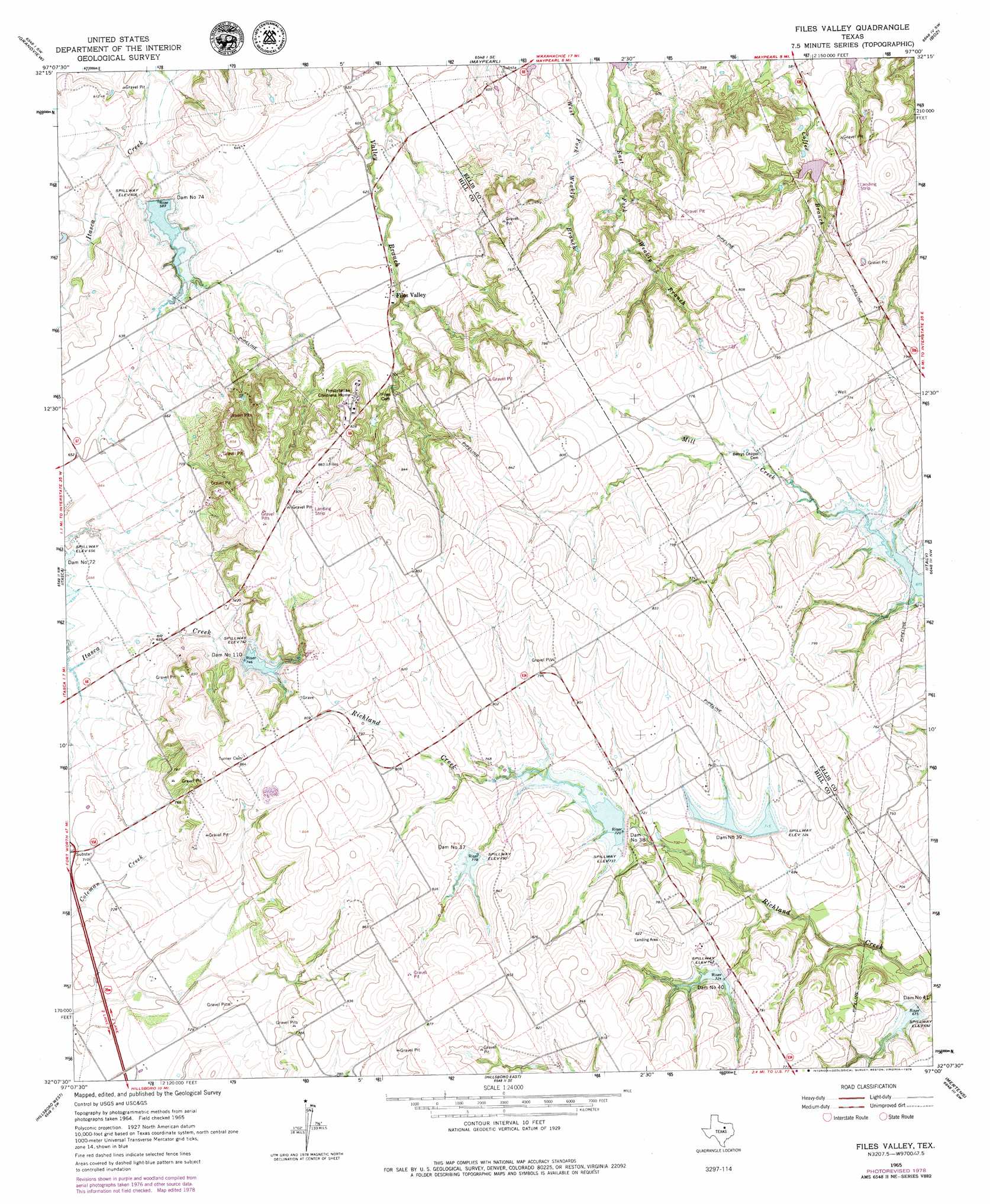
Files Valley Topo Map Texas
To zoom in, hover over the map of Files Valley
USGS Topo Quad 32097b1 - 1:24,000 scale
| Topo Map Name: | Files Valley |
| USGS Topo Quad ID: | 32097b1 |
| Print Size: | ca. 21 1/4" wide x 27" high |
| Southeast Coordinates: | 32.125° N latitude / 97° W longitude |
| Map Center Coordinates: | 32.1875° N latitude / 97.0625° W longitude |
| U.S. State: | TX |
| Filename: | o32097b1.jpg |
| Download Map JPG Image: | Files Valley topo map 1:24,000 scale |
| Map Type: | Topographic |
| Topo Series: | 7.5´ |
| Map Scale: | 1:24,000 |
| Source of Map Images: | United States Geological Survey (USGS) |
| Alternate Map Versions: |
Files Valley TX 1965, updated 1967 Download PDF Buy paper map Files Valley TX 1965, updated 1979 Download PDF Buy paper map Files Valley TX 2010 Download PDF Buy paper map Files Valley TX 2012 Download PDF Buy paper map Files Valley TX 2016 Download PDF Buy paper map |
1:24,000 Topo Quads surrounding Files Valley
Keene |
Alvarado |
Venus |
Midlothian |
Waxahachie |
Cleburne East |
Grandview |
Maypearl |
Boz |
Forreston |
Covington |
Itasca |
Files Valley |
Italy |
Avalon |
Blanton |
Hillsboro West |
Hillsboro East |
Mertens |
Frost |
Whitney |
Peoria |
Abbott |
Malone |
Irene |
> Back to 32097a1 at 1:100,000 scale
> Back to 32096a1 at 1:250,000 scale
> Back to U.S. Topo Maps home
Files Valley topo map: Gazetteer
Files Valley: Airports
Bee Creek Airport elevation 226m 741′Reece Ranch Airport elevation 266m 872′
Files Valley: Dams
Dam Number 110 elevation 227m 744′Dam Number 37 elevation 237m 777′
Dam Number 38 elevation 226m 741′
Dam Number 39 elevation 218m 715′
Dam Number 40 elevation 221m 725′
Dam Number 41 elevation 206m 675′
Dam Number 74 elevation 182m 597′
Soil Conservation Service Site 37 Dam elevation 241m 790′
Soil Conservation Service Site 38 Dam elevation 219m 718′
Soil Conservation Service Site 39 Dam elevation 214m 702′
Soil Conservation Service Site 40 Dam elevation 226m 741′
Soil Conservation Service Site 41 Dam elevation 206m 675′
Soil Conservation Service Site 72-A Dam elevation 224m 734′
Soil Conservation Service Site 74 Dam elevation 180m 590′
Soil Conservation Service Site 78 Dam elevation 195m 639′
Files Valley: Populated Places
Files Valley elevation 201m 659′Files Valley: Reservoirs
Soil Conservation Service Site 37 Reservoir elevation 241m 790′Soil Conservation Service Site 38 Reservoir elevation 219m 718′
Soil Conservation Service Site 39 Reservoir elevation 214m 702′
Soil Conservation Service Site 40 Reservoir elevation 226m 741′
Soil Conservation Service Site 41 Reservoir elevation 206m 675′
Soil Conservation Service Site 72-A Reservoir elevation 224m 734′
Soil Conservation Service Site 74 Reservoir elevation 180m 590′
Soil Conservation Service Site 78 Reservoir elevation 195m 639′
Files Valley digital topo map on disk
Buy this Files Valley topo map showing relief, roads, GPS coordinates and other geographical features, as a high-resolution digital map file on DVD: