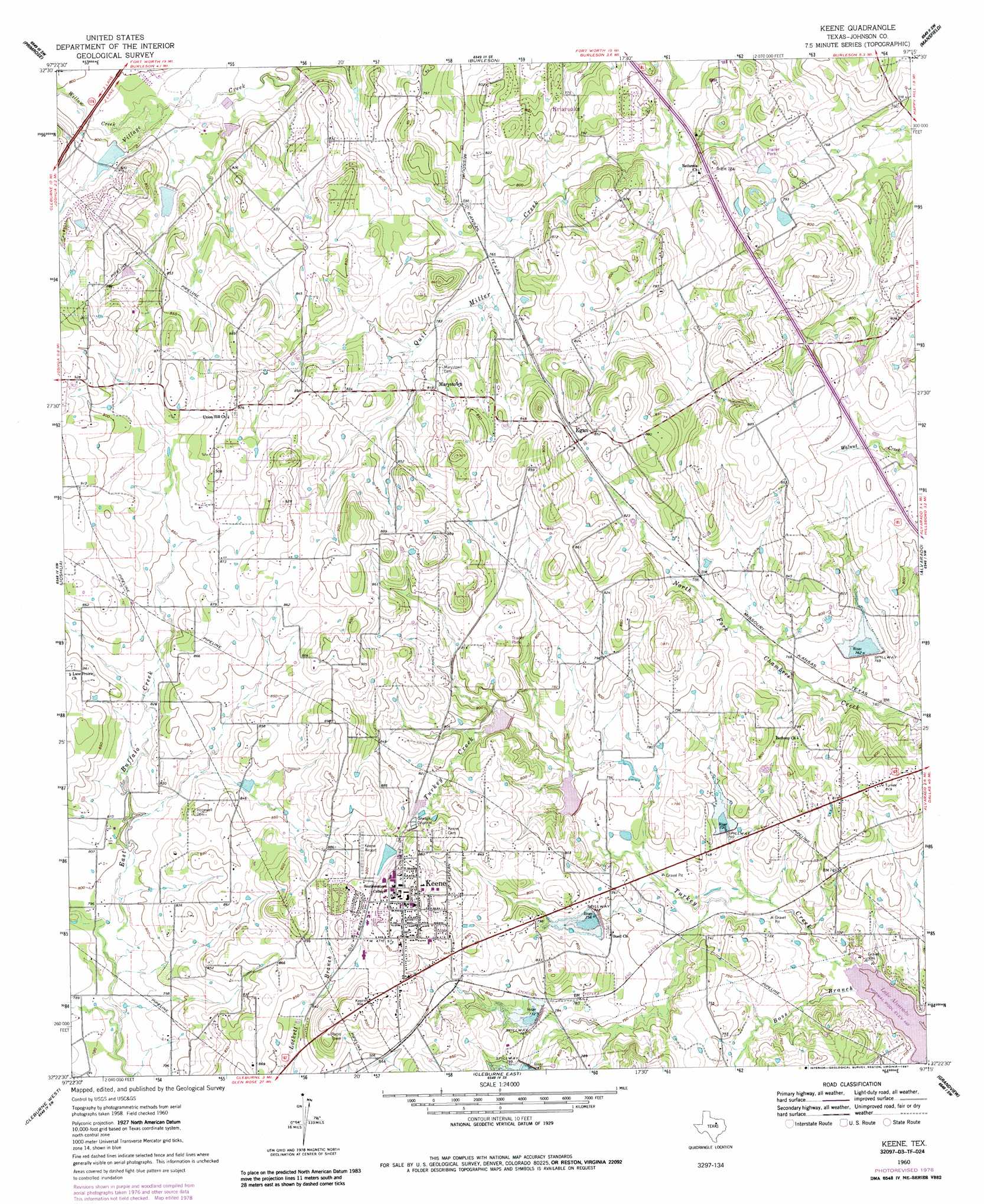
Keene Topo Map Texas
To zoom in, hover over the map of Keene
USGS Topo Quad 32097d3 - 1:24,000 scale
| Topo Map Name: | Keene |
| USGS Topo Quad ID: | 32097d3 |
| Print Size: | ca. 21 1/4" wide x 27" high |
| Southeast Coordinates: | 32.375° N latitude / 97.25° W longitude |
| Map Center Coordinates: | 32.4375° N latitude / 97.3125° W longitude |
| U.S. State: | TX |
| Filename: | o32097d3.jpg |
| Download Map JPG Image: | Keene topo map 1:24,000 scale |
| Map Type: | Topographic |
| Topo Series: | 7.5´ |
| Map Scale: | 1:24,000 |
| Source of Map Images: | United States Geological Survey (USGS) |
| Alternate Map Versions: |
Keene TX 1960, updated 1963 Download PDF Buy paper map Keene TX 1960, updated 1978 Download PDF Buy paper map Keene TX 1960, updated 1987 Download PDF Buy paper map Keene TX 2010 Download PDF Buy paper map Keene TX 2012 Download PDF Buy paper map Keene TX 2016 Download PDF Buy paper map |
1:24,000 Topo Quads surrounding Keene
Aledo |
Benbrook |
Fort Worth |
Kennedale |
Arlington |
Cresson |
Primrose |
Burleson |
Mansfield |
Britton |
Godley |
Joshua |
Keene |
Alvarado |
Venus |
Bono |
Cleburne West |
Cleburne East |
Grandview |
Maypearl |
Brazos Point |
Blum |
Covington |
Itasca |
Files Valley |
> Back to 32097a1 at 1:100,000 scale
> Back to 32096a1 at 1:250,000 scale
> Back to U.S. Topo Maps home
Keene topo map: Gazetteer
Keene: Airports
Peacock Willow Creek Heliport elevation 241m 790′Stol Field elevation 278m 912′
Keene: Dams
Mountain Valley Dam Number 1 elevation 240m 787′Mountain Valley Dam Number 2 elevation 247m 810′
Mountain Valley Lake Number 1 Dam elevation 242m 793′
Mountain Valley Lake Number 2 Dam elevation 247m 810′
Soil Conservation Service Site 30 Dam elevation 228m 748′
Soil Conservation Service Site 33 Dam elevation 228m 748′
Soil Conservation Service Site 33a Dam elevation 235m 770′
Soil Conservation Service Site 34 Dam elevation 229m 751′
Soil Conservation Service Site 35 Dam elevation 226m 741′
Soil Conservation Service Site 36 Dam elevation 238m 780′
Soil Conservation Service Site 37 Dam elevation 239m 784′
Keene: Populated Places
Egan elevation 256m 839′Keene elevation 272m 892′
Marystown elevation 247m 810′
Keene: Reservoirs
Mountain Valley Lake Number 1 elevation 242m 793′Mountain Valley Lake Number 2 elevation 247m 810′
Mountain Valley Reservoir Number 1 elevation 240m 787′
Mountain Valley Reservoir Number 2 elevation 247m 810′
Soil Conservation Service Site 30 Reservoir elevation 228m 748′
Soil Conservation Service Site 33 Reservoir elevation 228m 748′
Soil Conservation Service Site 33a Reservoir elevation 235m 770′
Soil Conservation Service Site 34 Reservoir elevation 229m 751′
Soil Conservation Service Site 35 Reservoir elevation 226m 741′
Soil Conservation Service Site 36 Reservoir elevation 238m 780′
Soil Conservation Service Site 37 Reservoir elevation 239m 784′
Keene: Streams
Boss Branch elevation 211m 692′Willow Creek elevation 235m 770′
Keene digital topo map on disk
Buy this Keene topo map showing relief, roads, GPS coordinates and other geographical features, as a high-resolution digital map file on DVD: