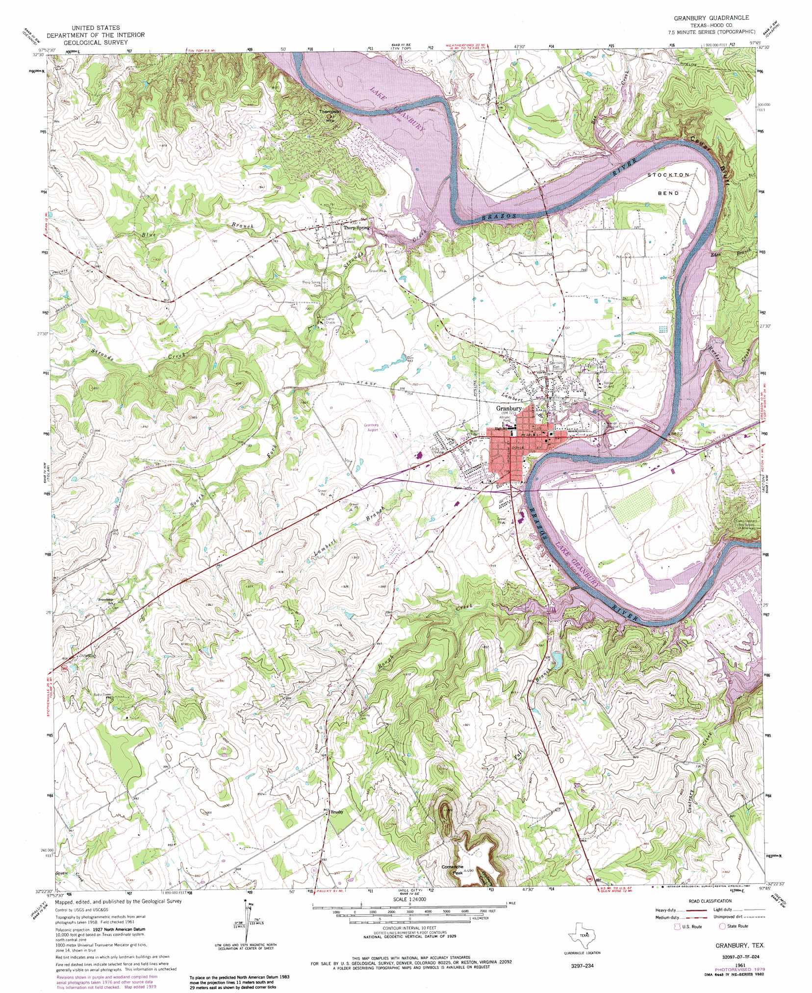
Granbury Topo Map Texas
To zoom in, hover over the map of Granbury
USGS Topo Quad 32097d7 - 1:24,000 scale
| Topo Map Name: | Granbury |
| USGS Topo Quad ID: | 32097d7 |
| Print Size: | ca. 21 1/4" wide x 27" high |
| Southeast Coordinates: | 32.375° N latitude / 97.75° W longitude |
| Map Center Coordinates: | 32.4375° N latitude / 97.8125° W longitude |
| U.S. State: | TX |
| Filename: | o32097d7.jpg |
| Download Map JPG Image: | Granbury topo map 1:24,000 scale |
| Map Type: | Topographic |
| Topo Series: | 7.5´ |
| Map Scale: | 1:24,000 |
| Source of Map Images: | United States Geological Survey (USGS) |
| Alternate Map Versions: |
Granbury TX 1961, updated 1963 Download PDF Buy paper map Granbury TX 1961, updated 1970 Download PDF Buy paper map Granbury TX 1961, updated 1987 Download PDF Buy paper map Granbury TX 2010 Download PDF Buy paper map Granbury TX 2013 Download PDF Buy paper map Granbury TX 2016 Download PDF Buy paper map |
1:24,000 Topo Quads surrounding Granbury
Brazos East |
Brock |
Weatherford South |
Anneta |
Aledo |
Lipan |
Dennis |
Tin Top |
Chapin |
Cresson |
Bluff Dale Ne |
Tolar |
Granbury |
Acton |
Godley |
Bluff Dale |
Paluxy |
Hill City |
Nemo |
Bono |
Johnsville |
Chalk Mountain |
Glen Rose West |
Glen Rose East |
Brazos Point |
> Back to 32097a1 at 1:100,000 scale
> Back to 32096a1 at 1:250,000 scale
> Back to U.S. Topo Maps home
Granbury topo map: Gazetteer
Granbury: Airports
Granbury Municipal Airport elevation 236m 774′Granbury: Bends
Peveler Valley elevation 211m 692′Stockton Bend elevation 214m 702′
Granbury: Cliffs
Cedar Bluff elevation 245m 803′Granbury: Dams
Bowser Lake Dam elevation 225m 738′Comanche Harbor Lake Dam elevation 224m 734′
Granbury: Parks
Granburry City Park elevation 223m 731′Pirate Stadium elevation 240m 787′
Granbury: Populated Places
Brazos Bend elevation 214m 702′Brushy elevation 295m 967′
Granbury elevation 224m 734′
Oak Trail Shores elevation 247m 810′
Thorp Spring elevation 231m 757′
Granbury: Reservoirs
Bowser Lake elevation 225m 738′Comanche Harbor Lake elevation 224m 734′
Granbury: Springs
Thorp Springs elevation 231m 757′Granbury: Streams
Bee Creek elevation 211m 692′Blue Branch elevation 212m 695′
Eden Branch elevation 211m 692′
Fall Branch elevation 211m 692′
Lambert Branch elevation 211m 692′
Rough Creek elevation 211m 692′
Rucker Creek elevation 211m 692′
South Fork Strouds Creek elevation 216m 708′
Strouds Creek elevation 211m 692′
Granbury: Summits
Comanche Peak elevation 373m 1223′Thompson Mountain elevation 247m 810′
Granbury digital topo map on disk
Buy this Granbury topo map showing relief, roads, GPS coordinates and other geographical features, as a high-resolution digital map file on DVD: