Mansfield Topo Map Texas
To zoom in, hover over the map of Mansfield
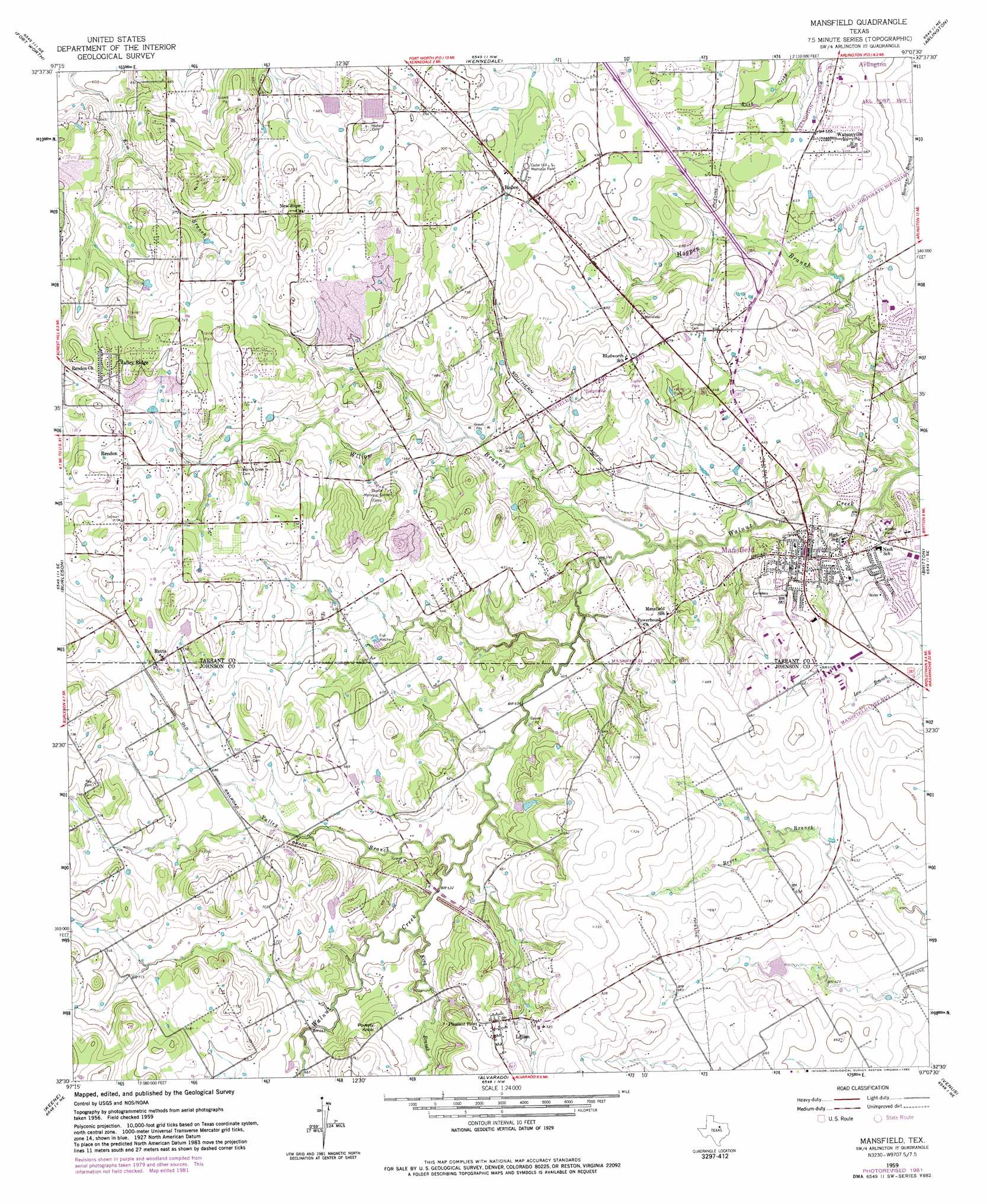
USGS Topo Quad 32097e2 - 1:24,000 scale
| Topo Map Name: | Mansfield |
| USGS Topo Quad ID: | 32097e2 |
| Print Size: | ca. 21 1/4" wide x 27" high |
| Southeast Coordinates: | 32.5° N latitude / 97.125° W longitude |
| Map Center Coordinates: | 32.5625° N latitude / 97.1875° W longitude |
| U.S. State: | TX |
| Filename: | o32097e2.jpg |
| Download Map JPG Image: | Mansfield topo map 1:24,000 scale |
| Map Type: | Topographic |
| Topo Series: | 7.5´ |
| Map Scale: | 1:24,000 |
| Source of Map Images: | United States Geological Survey (USGS) |
| Alternate Map Versions: |
Mansfield TX 1959, updated 1960 Download PDF Buy paper map Mansfield TX 1959, updated 1969 Download PDF Buy paper map Mansfield TX 1959, updated 1974 Download PDF Buy paper map Mansfield TX 1959, updated 1982 Download PDF Buy paper map Mansfield TX 1959, updated 1982 Download PDF Buy paper map Mansfield TX 2010 Download PDF Buy paper map Mansfield TX 2012 Download PDF Buy paper map Mansfield TX 2016 Download PDF Buy paper map |
1:24,000 Topo Quads surrounding Mansfield
Lake Worth |
Haltom City |
Hurst |
Euless |
Irving |
Benbrook |
Fort Worth |
Kennedale |
Arlington |
Duncanville |
Primrose |
Burleson |
Mansfield |
Britton |
Cedar Hill |
Joshua |
Keene |
Alvarado |
Venus |
Midlothian |
Cleburne West |
Cleburne East |
Grandview |
Maypearl |
Boz |
> Back to 32097e1 at 1:100,000 scale
> Back to 32096a1 at 1:250,000 scale
> Back to U.S. Topo Maps home
Mansfield topo map: Gazetteer
Mansfield: Airports
Alpine Range Airport elevation 204m 669′Flying L Airpark elevation 202m 662′
Flying W Heliport elevation 189m 620′
Hess Airport elevation 203m 666′
Napiers Heliport elevation 194m 636′
Retta Airport elevation 222m 728′
Short Field elevation 194m 636′
Southwest Custom Aircraft Heliport elevation 204m 669′
Mansfield: Dams
Carousel Farms Lake Dam elevation 193m 633′East Balancing Reservior Dam elevation 216m 708′
West Balancing Reservior Dam elevation 207m 679′
Mansfield: Parks
R L Anderson Stadium elevation 187m 613′Mansfield: Populated Places
Bisbee elevation 214m 702′Lillian elevation 220m 721′
Mansfield elevation 184m 603′
Rendon elevation 224m 734′
Retta elevation 226m 741′
Valley Ridge elevation 228m 748′
Watsonville elevation 207m 679′
Mansfield: Reservoirs
Carousel Farms Lake elevation 193m 633′East Balancing Reservoir elevation 216m 708′
West Balancing Reservoir elevation 207m 679′
Mansfield: Streams
King Branch elevation 192m 629′Valley Branch elevation 189m 620′
Willow Branch elevation 180m 590′
Mansfield: Summits
Poverty Knob elevation 216m 708′Mansfield: Trails
James McKnight Park Trail elevation 172m 564′Mansfield digital topo map on disk
Buy this Mansfield topo map showing relief, roads, GPS coordinates and other geographical features, as a high-resolution digital map file on DVD: