Dennis Topo Map Texas
To zoom in, hover over the map of Dennis
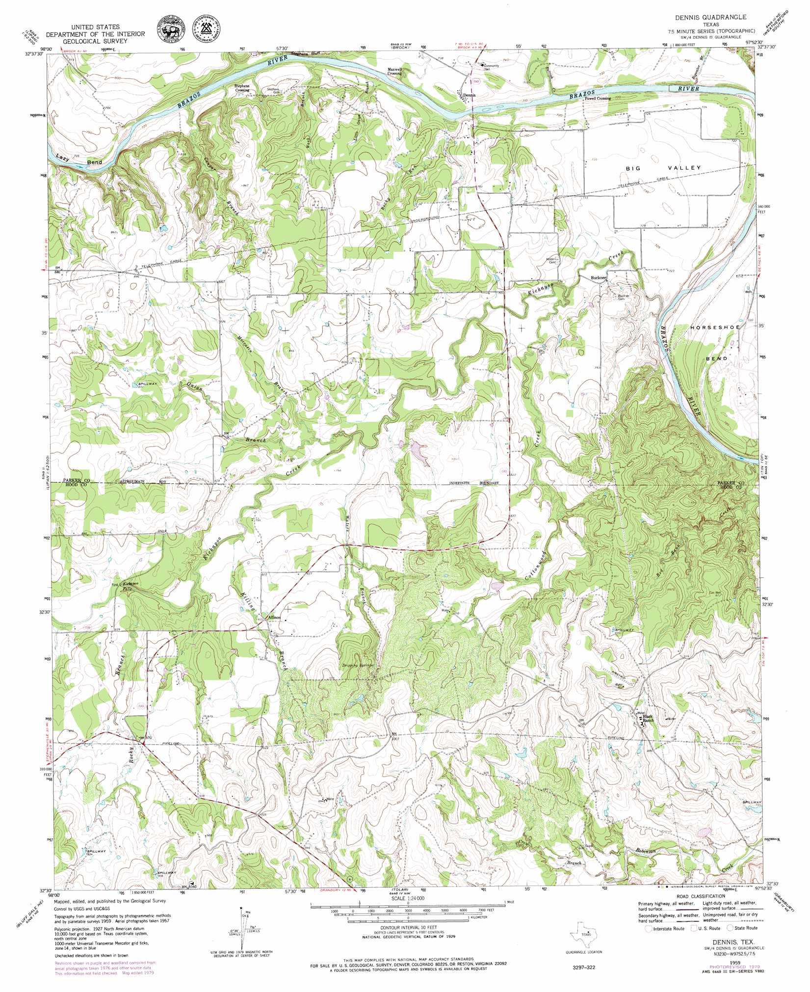
USGS Topo Quad 32097e8 - 1:24,000 scale
| Topo Map Name: | Dennis |
| USGS Topo Quad ID: | 32097e8 |
| Print Size: | ca. 21 1/4" wide x 27" high |
| Southeast Coordinates: | 32.5° N latitude / 97.875° W longitude |
| Map Center Coordinates: | 32.5625° N latitude / 97.9375° W longitude |
| U.S. State: | TX |
| Filename: | o32097e8.jpg |
| Download Map JPG Image: | Dennis topo map 1:24,000 scale |
| Map Type: | Topographic |
| Topo Series: | 7.5´ |
| Map Scale: | 1:24,000 |
| Source of Map Images: | United States Geological Survey (USGS) |
| Alternate Map Versions: |
Dennis TX 1959, updated 1960 Download PDF Buy paper map Dennis TX 1959, updated 1974 Download PDF Buy paper map Dennis TX 1959, updated 1979 Download PDF Buy paper map Dennis TX 2010 Download PDF Buy paper map Dennis TX 2013 Download PDF Buy paper map Dennis TX 2016 Download PDF Buy paper map |
1:24,000 Topo Quads surrounding Dennis
Mineral Wells West |
Mineral Wells East |
Garner |
Weatherford North |
Lake Weatherford |
Brazos West |
Brazos East |
Brock |
Weatherford South |
Anneta |
Santo |
Lipan |
Dennis |
Tin Top |
Chapin |
Morgan Mill |
Bluff Dale Ne |
Tolar |
Granbury |
Acton |
Knob Hill |
Bluff Dale |
Paluxy |
Hill City |
Nemo |
> Back to 32097e1 at 1:100,000 scale
> Back to 32096a1 at 1:250,000 scale
> Back to U.S. Topo Maps home
Dennis topo map: Gazetteer
Dennis: Bends
Big Valley elevation 222m 728′Horseshoe Bend elevation 219m 718′
Lazy Bend elevation 225m 738′
Dennis: Dams
Aldenhoven Lake Dam elevation 293m 961′Black Lake Number 2 Dam elevation 258m 846′
Black Lake Number 3 Dam elevation 246m 807′
Black Lake Number 4 Dam elevation 257m 843′
Dennis: Falls
Kickapoo Falls elevation 244m 800′Dennis: Populated Places
Allison elevation 256m 839′Buckner elevation 223m 731′
Dennis elevation 222m 728′
Maxwell Crossing elevation 221m 725′
Powell Crossing elevation 216m 708′
Stephens Crossing elevation 233m 764′
Dennis: Reservoirs
Aldenhoven Lake elevation 293m 961′Black Lake Number 2 elevation 258m 846′
Black Lake Number 3 elevation 246m 807′
Black Lake Number 4 elevation 257m 843′
Dennis: Springs
Dripping Springs elevation 260m 853′Dripping Springs elevation 272m 892′
Dennis: Streams
Bigwater Branch elevation 213m 698′Cottonwood Creek elevation 216m 708′
Cougar Branch elevation 223m 731′
Crow Branch elevation 229m 751′
Kickapoo Creek elevation 212m 695′
Killing Branch elevation 233m 764′
Little Onion Branch elevation 216m 708′
Moccasin Branch elevation 232m 761′
Onion Branch elevation 232m 761′
Patrick Creek elevation 216m 708′
Red Bank Creek elevation 213m 698′
Rocky Branch elevation 241m 790′
Rocky Run elevation 220m 721′
Wash Branch elevation 217m 711′
Waters Branch elevation 228m 748′
Dennis digital topo map on disk
Buy this Dennis topo map showing relief, roads, GPS coordinates and other geographical features, as a high-resolution digital map file on DVD: