Fort Worth Topo Map Texas
To zoom in, hover over the map of Fort Worth
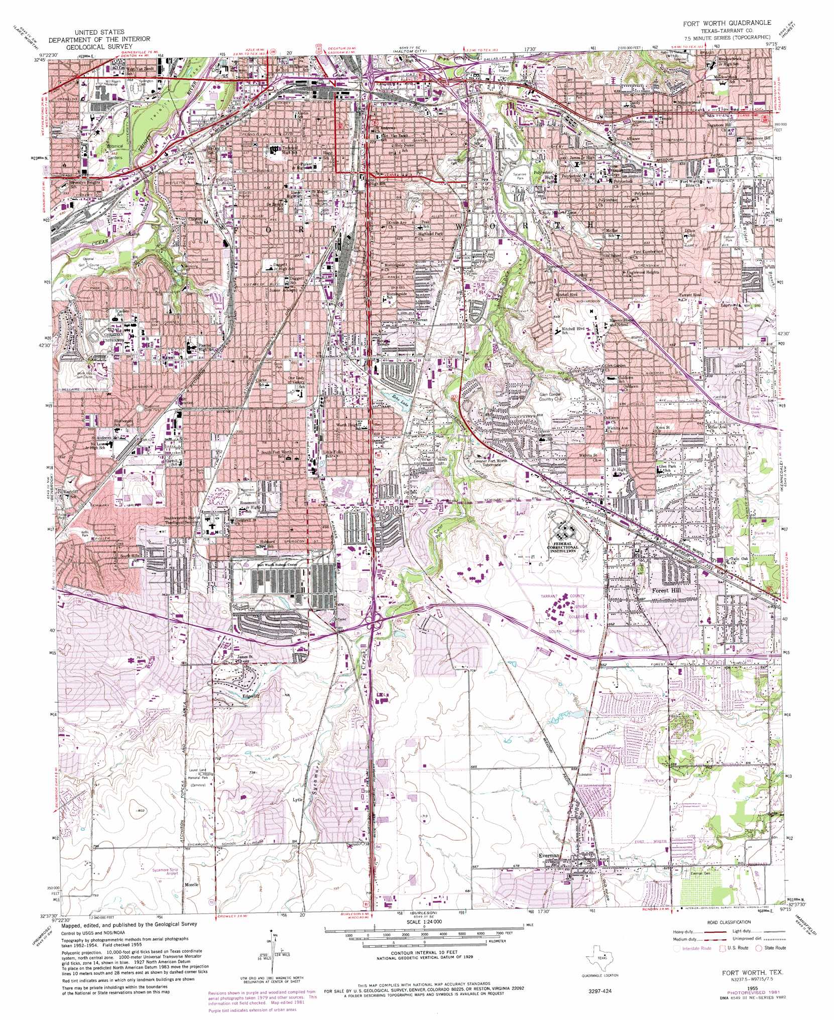
USGS Topo Quad 32097f3 - 1:24,000 scale
| Topo Map Name: | Fort Worth |
| USGS Topo Quad ID: | 32097f3 |
| Print Size: | ca. 21 1/4" wide x 27" high |
| Southeast Coordinates: | 32.625° N latitude / 97.25° W longitude |
| Map Center Coordinates: | 32.6875° N latitude / 97.3125° W longitude |
| U.S. State: | TX |
| Filename: | o32097f3.jpg |
| Download Map JPG Image: | Fort Worth topo map 1:24,000 scale |
| Map Type: | Topographic |
| Topo Series: | 7.5´ |
| Map Scale: | 1:24,000 |
| Source of Map Images: | United States Geological Survey (USGS) |
| Alternate Map Versions: |
Fort Worth TX 1955, updated 1957 Download PDF Buy paper map Fort Worth TX 1955, updated 1969 Download PDF Buy paper map Fort Worth TX 1955, updated 1974 Download PDF Buy paper map Fort Worth TX 1955, updated 1982 Download PDF Buy paper map Fort Worth TX 1955, updated 1982 Download PDF Buy paper map Fort Worth TX 1995, updated 2001 Download PDF Buy paper map Fort Worth TX 2010 Download PDF Buy paper map Fort Worth TX 2012 Download PDF Buy paper map Fort Worth TX 2016 Download PDF Buy paper map |
1:24,000 Topo Quads surrounding Fort Worth
Azle |
Avondale |
Keller |
Colleyville |
Grapevine |
Springtown Se |
Lake Worth |
Haltom City |
Hurst |
Euless |
Aledo |
Benbrook |
Fort Worth |
Kennedale |
Arlington |
Cresson |
Primrose |
Burleson |
Mansfield |
Britton |
Godley |
Joshua |
Keene |
Alvarado |
Venus |
> Back to 32097e1 at 1:100,000 scale
> Back to 32096a1 at 1:250,000 scale
> Back to U.S. Topo Maps home
Fort Worth topo map: Gazetteer
Fort Worth: Airports
Fwomc Heliport elevation 194m 636′Harris Hospital Heliport elevation 196m 643′
Health Department Heliport elevation 171m 561′
Saint Joseph Hospital Heliport elevation 203m 666′
Sycamore Strip elevation 232m 761′
TCJC-South Campus Heliport elevation 203m 666′
Water Department Heliport elevation 168m 551′
Fort Worth: Crossings
Interchange 11B elevation 179m 587′Interchange 12A elevation 170m 557′
Interchange 12B elevation 166m 544′
Interchange 12C elevation 170m 557′
Interchange 13 elevation 189m 620′
Interchange 14 elevation 186m 610′
Interchange 15 elevation 178m 583′
Interchange 16A and 16B elevation 157m 515′
Interchange 16C elevation 162m 531′
Interchange 435 elevation 233m 764′
Interchange 436A elevation 220m 721′
Interchange 436B elevation 210m 688′
Interchange 436C elevation 201m 659′
Interchange 437A elevation 199m 652′
Interchange 437B elevation 201m 659′
Interchange 438 elevation 202m 662′
Interchange 439 elevation 208m 682′
Interchange 440A elevation 198m 649′
Interchange 440B elevation 198m 649′
Interchange 441 elevation 200m 656′
Fort Worth: Dams
Echo Lake Dam elevation 189m 620′Fort Worth: Lakes
Elliot Lake elevation 179m 587′Fort Worth: Parks
Amon G Carter Stadium - Texas Christian University elevation 190m 623′Bayard H Friedman Tennis Center elevation 195m 639′
Bluebonnet Circle Park elevation 202m 662′
Capps Park elevation 212m 695′
Carter Park Site elevation 188m 616′
Cobb Park elevation 172m 564′
Daniel-Meyer Coliseum - Texas Christian University elevation 193m 633′
Davis Park elevation 222m 728′
Eastover Park elevation 195m 639′
Ellis Park elevation 175m 574′
Fairfax Park elevation 189m 620′
Farrington Field elevation 169m 554′
Farrington Field elevation 170m 557′
Forest Park elevation 169m 554′
Fort Worth Water Gardens elevation 187m 613′
Garvey - Rosenthal Soccer Stadium elevation 196m 643′
Glenwood Park elevation 167m 547′
Greenbriar Park elevation 211m 692′
Hallmark Park elevation 210m 688′
Haynes Park elevation 186m 610′
Herman Clark Stadium elevation 201m 659′
Highland Hills Park elevation 210m 688′
Hillside Park elevation 194m 636′
Jeff Davis Park elevation 224m 734′
Kellis Park elevation 205m 672′
Little People Park elevation 238m 780′
Lowdon Track and Field Complex elevation 207m 679′
Lupton Baseball Stadium - Texas Christian University elevation 202m 662′
Masonic Home Field elevation 202m 662′
Meadowbrook Park elevation 179m 587′
Newby Park elevation 180m 590′
Normandy Park elevation 186m 610′
Pate Park elevation 187m 613′
Prairie Dog Park elevation 187m 613′
Rolling Hills Park elevation 204m 669′
Rolling Hills Rugby and Soccer Complex elevation 204m 669′
Rosemont Park elevation 221m 725′
Sagamore Park elevation 198m 649′
Seminary Hill Park elevation 219m 718′
South Creek Park elevation 223m 731′
Stephens Park elevation 233m 764′
Sycamore Park elevation 164m 538′
Tandy Hills Park elevation 181m 593′
TCU Recreation Center elevation 198m 649′
Timber View Park elevation 181m 593′
Trinity Park elevation 166m 544′
Van Zandt Guinn Park elevation 191m 626′
Village Creek Park elevation 193m 633′
Wedgeworth Park elevation 228m 748′
Westcreek Park elevation 216m 708′
Will Rogers Memorial elevation 179m 587′
Fort Worth: Populated Places
Belt Junction elevation 205m 672′Edgecliff Village elevation 209m 685′
Everman elevation 204m 669′
Forest Hill elevation 208m 682′
Fort Worth elevation 199m 652′
Lytle elevation 210m 688′
Moselle elevation 232m 761′
Fort Worth: Post Offices
United States Post Office elevation 188m 616′Fort Worth: Reservoirs
Echo Lake elevation 189m 620′Fort Worth: Springs
Cold Springs elevation 189m 620′Fort Worth: Trails
Tandy Hills Trail elevation 174m 570′Fort Worth digital topo map on disk
Buy this Fort Worth topo map showing relief, roads, GPS coordinates and other geographical features, as a high-resolution digital map file on DVD: