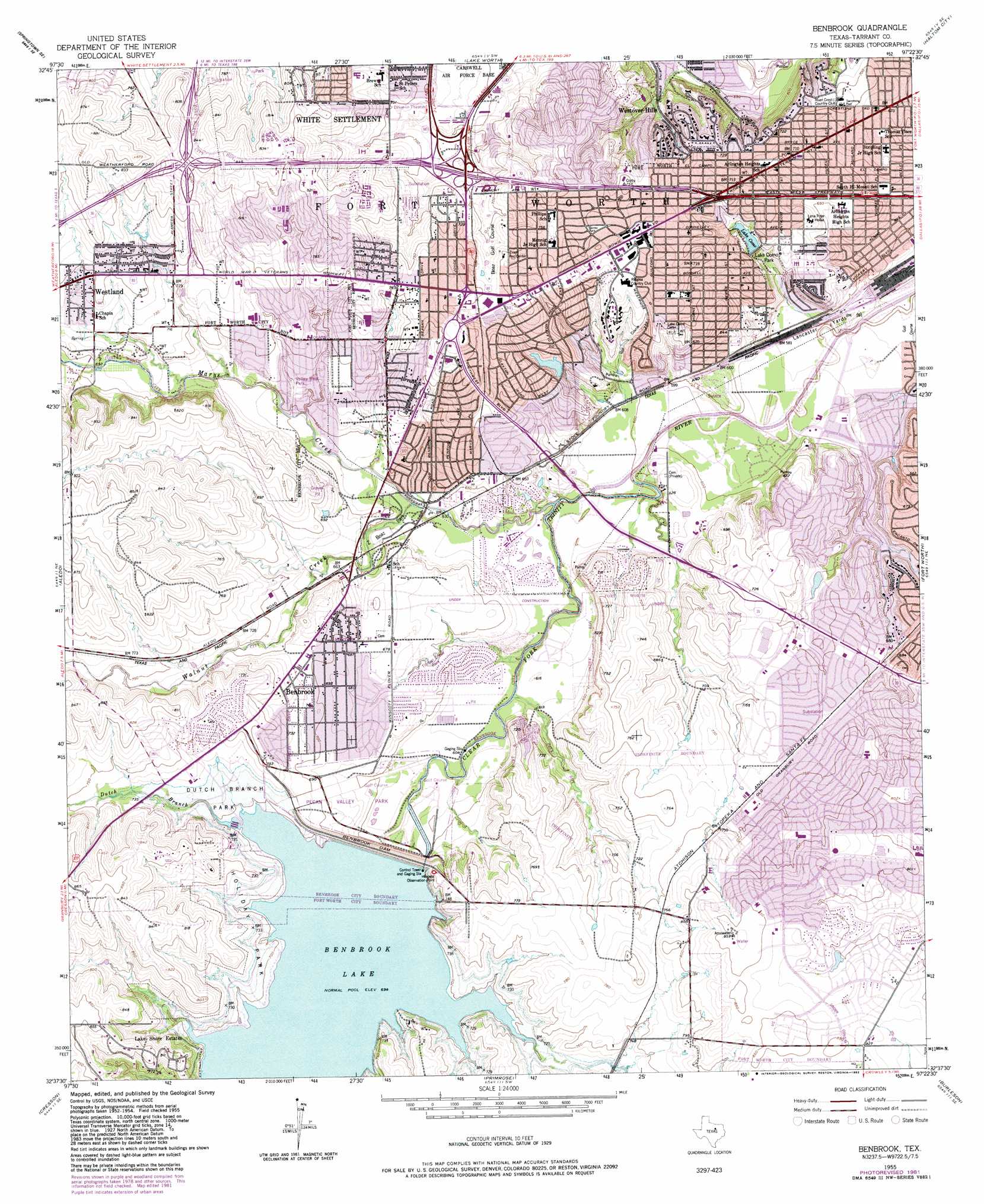
Benbrook Topo Map Texas
To zoom in, hover over the map of Benbrook
USGS Topo Quad 32097f4 - 1:24,000 scale
| Topo Map Name: | Benbrook |
| USGS Topo Quad ID: | 32097f4 |
| Print Size: | ca. 21 1/4" wide x 27" high |
| Southeast Coordinates: | 32.625° N latitude / 97.375° W longitude |
| Map Center Coordinates: | 32.6875° N latitude / 97.4375° W longitude |
| U.S. State: | TX |
| Filename: | o32097f4.jpg |
| Download Map JPG Image: | Benbrook topo map 1:24,000 scale |
| Map Type: | Topographic |
| Topo Series: | 7.5´ |
| Map Scale: | 1:24,000 |
| Source of Map Images: | United States Geological Survey (USGS) |
| Alternate Map Versions: |
Benbrook TX 1955, updated 1957 Download PDF Buy paper map Benbrook TX 1955, updated 1969 Download PDF Buy paper map Benbrook TX 1955, updated 1974 Download PDF Buy paper map Benbrook TX 1955, updated 1982 Download PDF Buy paper map Benbrook TX 1995, updated 2001 Download PDF Buy paper map Benbrook TX 2010 Download PDF Buy paper map Benbrook TX 2012 Download PDF Buy paper map Benbrook TX 2016 Download PDF Buy paper map |
1:24,000 Topo Quads surrounding Benbrook
Springtown |
Azle |
Avondale |
Keller |
Colleyville |
Lake Weatherford |
Springtown Se |
Lake Worth |
Haltom City |
Hurst |
Anneta |
Aledo |
Benbrook |
Fort Worth |
Kennedale |
Chapin |
Cresson |
Primrose |
Burleson |
Mansfield |
Acton |
Godley |
Joshua |
Keene |
Alvarado |
> Back to 32097e1 at 1:100,000 scale
> Back to 32096a1 at 1:250,000 scale
> Back to U.S. Topo Maps home
Benbrook topo map: Gazetteer
Benbrook: Airports
Harris Methodist Southwest Helistop elevation 231m 757′Jmk International Incorporated Heliport elevation 213m 698′
Benbrook: Crossings
Interchange 10 elevation 201m 659′Interchange 3 elevation 238m 780′
Interchange 428 elevation 237m 777′
Interchange 429A elevation 237m 777′
Interchange 429B elevation 207m 679′
Interchange 431 elevation 216m 708′
Interchange 433 elevation 210m 688′
Interchange 433A elevation 209m 685′
Interchange 434A elevation 215m 705′
Interchange 434B elevation 232m 761′
Interchange 5A elevation 249m 816′
Interchange 5B and 5C elevation 243m 797′
Interchange 6 elevation 244m 800′
Interchange 7A and 7B elevation 207m 679′
Interchange 8A elevation 231m 757′
Interchange 8B elevation 229m 751′
Interchange 9A elevation 223m 731′
Interchange 9B elevation 215m 705′
Benbrook: Dams
Benbrook Dam elevation 214m 702′Lake Como Dam elevation 198m 649′
Luther Lake Dam elevation 205m 672′
Willow Creek Lake Dam elevation 203m 666′
Benbrook: Parks
All Saints Field elevation 247m 810′Bear Stadium elevation 226m 741′
Berrey Park elevation 228m 748′
Boaz Park elevation 190m 623′
Brewer High School Baseball Stadium elevation 227m 744′
Brewer High School Softball Stadium elevation 219m 718′
Candleridge Park elevation 239m 784′
Clear Fork Park elevation 193m 633′
Collett Park elevation 179m 587′
Dutch Branch Park elevation 218m 715′
Eagle Stadium elevation 238m 780′
Fort Worth Country Day School Baseball Field elevation 185m 606′
Foster Park elevation 207m 679′
Goodman Park elevation 228m 748′
Hartwood Park elevation 177m 580′
Holiday Park elevation 223m 731′
Lake Como Park elevation 183m 600′
Leonard Park elevation 217m 711′
Longhorn Park elevation 227m 744′
McNair Stadium elevation 246m 807′
Overton Park elevation 174m 570′
Pecan Valley Park elevation 213m 698′
Roaring Park elevation 197m 646′
Rosacker Field elevation 184m 603′
Rosenthal Park elevation 247m 810′
Rosenthal Stadium elevation 232m 761′
Southwest Christian School Baseball Field elevation 237m 777′
Southwest Park elevation 252m 826′
Timber Creek Park elevation 198m 649′
Trinity Valley School Baseball Field elevation 231m 757′
Trinity Valley School Softball Field elevation 229m 751′
Valley West Park elevation 205m 672′
Wedgewood Park elevation 230m 754′
Woodlawn Park elevation 199m 652′
Benbrook: Populated Places
Benbrook elevation 210m 688′Lake Shore Estates elevation 220m 721′
Westland elevation 229m 751′
Westover Hills elevation 182m 597′
Benbrook: Reservoirs
Benbrook Lake elevation 217m 711′Lake Como elevation 198m 649′
Luther Lake elevation 205m 672′
Willow Creek Lake elevation 203m 666′
Benbrook: Streams
Dutch Branch elevation 212m 695′Marys Creek elevation 177m 580′
Walnut Creek elevation 186m 610′
Benbrook: Trails
Benbrook Lake Trail elevation 214m 702′Benbrook digital topo map on disk
Buy this Benbrook topo map showing relief, roads, GPS coordinates and other geographical features, as a high-resolution digital map file on DVD: